June 17th Street
|
|
|
|---|---|
| Street in Berlin | |
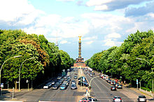
| View of the Strasse des 17. Juni from the Großer Stern ( Victory Column ) to the east to the Brandenburg Gate . Behind it in the middle on the horizon the Red City Hall , to the left of it the Berlin TV Tower | |
| Basic data | |
| place | Berlin |
| District | Tiergarten , Charlottenburg , |
| Created | 1697 |
| Hist. Names |
Charlottenburger Chaussee, east-west axis |
| Connecting roads |
Unter den Linden , Bismarckstrasse |
| Cross streets | Yzak-Rabin-Strasse, Hofjägerallee , Spreeweg , Altonaer Strasse , Klopstockstrasse, Bachstrasse, Salzufer, Einsteinufer, Müller-Breslau-Strasse |
| Places |
March 18th Place , Großer Stern , Ernst-Reuter-Platz |
| Buildings | Brandenburg Gate , Soviet Memorial , Victory Column , Berlin Pavilion , Technical University |
| use | |
| User groups | Pedestrian traffic , bicycle traffic , car traffic , public transport |
| Technical specifications | |
| Street length | 3580 meters |
The Straße des 17. Juni ( colloquially : [the] 17. Juni ) is part of the great east-west axis in Berlin and part of the federal highways B 2 and B 5 . The street is located in the districts of Tiergarten ( Mitte district ) and Charlottenburg ( Charlottenburg-Wilmersdorf district ). Its name is reminiscent of the popular uprising in the GDR in 1953 .
course
The street begins in the Tiergarten district in front of the Brandenburg Gate on the border with the Mitte district at Platz des 18. März as an extension of Unter den Linden . It runs through the Great Zoo and is interrupted there by the Great Star . With the Charlottenburg Bridge , it crosses the Landwehr Canal and reaches the district of Charlottenburg. There it is flanked by the Charlottenburger Tor , which is a counterpart to the Brandenburg Gate in terms of the zoo's boundaries. To the west it leads past the Federal Office for Building and Regional Planning , cuts through the main campus of the Technical University and ends at Ernst-Reuter-Platz .
history
The street was built in 1697 at the instigation of Elector Friedrich III. and served as a connection between his city palace and the Lietzenburg palace that he built. When Sophie Charlotte von Hanover - the wife of the meanwhile King Friedrich I of Prussia - died in 1705, the Lietzenburg became Charlottenburg Palace and the street leading there was given the name Charlottenburger Chaussee (up to the border from Charlottenburg; the rest of the section was called Berliner Strasse , reflecting the Charlottenburg view . In the middle of the 18th century, the entire route from the Brandenburg Gate to Charlottenburg Palace was expanded as a wide avenue.
Simon Kremser's first Berlin horse-drawn buses operated here from 1820, the first Berlin horse-drawn tram from 1865 and battery- powered electric trams from 1897 to 1902 .

The Straße des 17. Juni only became the “ World Capital Germania ” during the National Socialist era as part of the concept for the conversion of Berlin into the “ World Capital Germania ” planned by Adolf Hitler and Albert Speer to the current width of up to 45 meters (85 meters directly in the area of the Great Star) expanded. In 1934, the expansion plans of the Nazis also had to give way to the oldest tram route , which had led from the Kupfergraben through the Tiergarten to Charlottenburg since 1865 . The representative Paradestrasse thus created was officially named East-West Axis in 1935 . In addition, the Victory Column , which originally adorned Königsplatz - today's Republic Square in front of the Reichstag building - was integrated into the Großer Stern in 1938. Since then, it has been the landmark of the widely visible center of Strasse des 17. Juni.

In the summer of 1945 the Red Army erected the Soviet War Memorial near the Brandenburg Gate across the former Siegesallee .
The street has had its current name since the decision of the Berlin Senate of June 22, 1953 in memory of the popular uprising in the GDR on June 17, 1953 - the date of which was a national holiday in the Federal Republic of Germany until 1990. On November 3, 1953, the name was extended to the short section of Charlottenburg from the Tiergarten S-Bahn station to Ernst-Reuter-Platz.
As a further memorial for German unity, a three-meter-long wall memorial was erected to the west of the junction at that time between Straße des 17. Juni and Entlastungsstraße (today: Yitzhak-Rabin-Straße) near the Soviet memorial immediately after the Berlin Wall was built in 1961 the board of trustees for indivisible Germany . It bears the inscriptions “To the victims of the red dictatorship” and “Your freedom is our mission”. The memorial was removed in 2019.
Since May 19, 1989, the bronze sculpture Der Rufer , a replica by the artist Gerhard Marcks , has adorned the median of Strasse des 17. Juni in the immediate vicinity of the Brandenburg Gate . With its orientation towards the former eastern part of the city and the slogan “I go through the world and call peace, peace, peace” on the base, which is intended to underline its allegorical character of freedom of expression , the statue has a strong political reference.
State of development

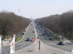
The Straße des 17. Juni has three lanes, sometimes four lanes, for both directions. The directional lanes are structurally separated by a median. At the Großer Stern, the carriageway is widened to up to six lanes and a wide shoulder.
What is striking is the existence of parking spaces on the median and at the edge of the roadway, which many visitors to the zoo can use as free parking, in contrast to the areas with parking space management in the inner city areas.
Today's design, which is now under monument protection , especially the typical street lamps, was largely designed by Albert Speer . This continues in a westerly direction, where the uniform street is then called Bismarckstrasse (to Sophie-Charlotte-Platz) or Kaiserdamm (to Theodor-Heuss-Platz ).
Of the formerly planned development outside the zoo, only today's Ernst-Reuter-Haus , seat of the Federal Office for Building and Regional Planning , has been realized.
Special events
Numerous extraordinary events took place on the Straße des 17. Juni and its extensions: In the 1920s, for example, the young Wernher von Braun tried out a self-made rocket car here. In 1938, the section through the zoo with the big star and the Victory Column , which had meanwhile been moved from the Reichstag building , was laid out.
Shortly before the end of and after the Second World War , the Straße des 17. Juni was temporarily used as a flight runway because the trees in the zoo had been cut down. The checkpoint was on the top of the victory column. Hanna Reitsch , for example, used the avenue as a runway on the night of April 28-29, 1945 to leave Berlin, which was enclosed by the Red Army.
Since 1963, the SUR research nuclear reactor has been operated in the immediate vicinity of the Institute for Energy Technology at the Technical University of Berlin , and it is planned to shut down.
Since the post-war period , major events have often taken place on Straße des 17. Juni , such as the troop parades of the Allied Western powers until 1989 , the Love Parade from 1996 to 2003 and 2006 , the Mini Love Parade in July 2005 or the Live 8 concert on July 2 2005. Since 2002, the Türkgünü , Berlin's Turkish- European cultural festival , has also taken place every year on Straße des 17. Juni .
As part of the soccer world championship in 2006 , the street was declared an official fan mile after heated political discussions , so it was closed to motorists for six weeks and equipped with big screens. As a replacement for the pompously planned and then canceled opening ceremony in the Berlin Olympic Stadium - according to the organizers' calculation - a family festival should take place on the fan mile. Contrary to all fears, the fan mile was a great success at the 2006 World Cup. The fan mile ended on July 9, 2006 with the celebration of the German national team . The players were reportedly received and celebrated by around a million people. The fan festivals have since been repeated at all European and World Championships.
In the year of the 25th anniversary of the fall of the Berlin Wall , the British artist Hamish Fulton developed a hike entitled “Walking East - Walking West” for the Strasse des 17. Juni for the exhibition “Vertigo of Reality” at the Akademie der Künste . September 2014 two groups of 400 people each should run towards each other in a long row. The participants move slowly past one another, each with a distance of 50 cm: East to West and West to East.
In order to facilitate the now frequent use of the section near the Brandenburg Gate for outdoor events, this area received fixed installations in 2009/2010, for example for electricity.
The Charlottenburg flea market takes place every weekend between the Tiergarten S-Bahn station and the Charlottenburger Tor . The market is divided into a flea market (east of the Charlottenburger Tor) and a handicraft market (west of the Charlottenburger Tor) and attracts a large number of visitors and tourists.
Web links
-
June 17th Street. In: Street name lexicon of the Luisenstädtischer Bildungsverein (near Kaupert )
- Berliner Strasse . In: Luise.
Individual evidence
- ↑ The Soviet Memorial in the Tiergarten is located in the Great Tiergarten in the Tiergarten district of Berlin
- ↑ Berlin-Tiergarten: First memorial to the victims of the Berlin Wall badly damaged. In: spreepicture.com. Retrieved August 3, 2019 .
- ↑ For the capacity of the street, see: The one million people question . In: taz , December 31, 2013.
Coordinates: 52 ° 30 ′ 51 ″ N , 13 ° 21 ′ 2 ″ E


