Titi Island (Marlborough)
| Titi Island | ||
|---|---|---|
| Waters | Marlborough Sounds / Cook Street | |
| Geographical location | 40 ° 57 ′ S , 174 ° 8 ′ E | |
|
|
||
| length | 1.1 km | |
| width | 330 m | |
| surface | 0.32 | |
| Highest elevation | 99 m | |
| Residents | uninhabited | |
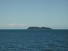
Titi Island (after the Māori name for the dark shearwater ) is an island in the Marlborough Sounds in the Marlborough region of New Zealand .
The island is off Alligator Head on the Cook Strait . The closest small settlement is Titiranga .
The island is about 1.1 km long and at its widest a little over 330 m wide and covers an area of 32 hectares. The highest point on the island is 99 m high. The island is 1,900 m away from the mainland at Alligator Head.
literature
- New Zealand Travel Atlas , Wise Maps Auckland ISBN 0-908794-47-9 .
Individual evidence
- ↑ a b Titi Island . In: Rodent Invasion Project . Department of Statistics , 2005, archived from the original on May 24, 2006 ; accessed on April 27, 2018 (English, original website no longer available).

