
Tsitsikamma National Park
|
Tsitsikamma National Park
|
|
 Lagoon in Nature's Valley east of Plettenberg Bay |
|
| location | South Africa |
| surface | 639.42 km² |
| WDPA ID | 881 |
| Geographical location | 34 ° 1 ' S , 23 ° 54' E |

|
|
| Setup date | 1964 |
| administration | South African National Parks |
The Tsitsikamma National Park was an independent national park in South Africa until 2009 . Since then it has been part of the Garden Route National Park . It is located in the Sarah Baartman district in the western part of the Eastern Cape Province .
Profile of the park
The park, with an area of 29,838 hectares, was opened in 1964 and stretched for almost 100 kilometers along the coast between Cape St. Francis and Plettenberg Bay . It encompassed not only the original primeval forest on land, but also a 5.5 km wide strip of the coastal sea. The vegetation there is very lush and diverse. The dense forest with its old trees, up to 40 meters high, is one of the last primeval forests in South Africa. Particularly noteworthy here are the yellowwood trees ( broad-leaved stone slab , Podocarpus latifolius) . Thanks to the high annual rainfall of up to 1,200 mm, many streams and rivers flow from the Tsitsikamma Mountains to the sea. There is also a species-rich bird world, monkeys and smaller antelope species . Dolphins and whales are common off the coast.
The name Tsitsikamma means something like “water-rich place” or “where the water begins” in the Khoikhoi language .
On March 6, 2009, the park was incorporated into the Garden Route National Park .
Otter Trail
The Otter Trail is a hiking trail that runs 25 miles along the coast from the mouth of the Storms River to Nature's Valley. The Otter Trail is an unguided tour for two groups of six people each per day. The park administration stipulates five overnight stays in huts provided for this purpose. The daily mileage is between 4.8 (first day) and 13.8 kilometers. There are sometimes several climbs to the high plateau and back to the coast.
gallery
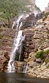
The waterfall at the start of the Otter Trail

Tsitsikamma National Park coast

Tsitsikamma National Park cliffs


Web links
- South African National Parks: Garden Route National Park . National park administration website at www.sanparks.org (English)
- Statistics South Africa : Tsitsikamma National Park . on www.statssa.gov.za (English)
- Dry feet in the waves of Tsitsikamma , video of the coast
Individual evidence
- ^ Department of Arts and Culture: Place Names . at www.salanguages.com (English); see entry Kou-Kamma Local Municipality .
- ^ Establishment of the Garden Route National Park . Department of Environmental Affairs and Tourism. March 6, 2009. Archived from the original on February 13, 2012. Retrieved on March 9, 2009.