AIDS balets
| AIDS balets | ||

|
||

|
||
| Data | ||
| surface | 99.39 km² | |
| population | 5,438 (2015) | |
| Chefe de Suco | Francisco Fontes (election 2016) |
|
| Aldeias | Population (2015) | |
| AIDS balets | 574 | |
| Biacou | 579 | |
| Harame | 504 | |
| Meguir | 537 | |
| Sulilaran | 758 | |
| Tasi mean | 955 | |
| Tutubaba | 1,531 | |
|
|
||
Aidabaleten is the name of two East Timorese places in Suco Aidabaleten ( Atabae administrative office , Bobonaro municipality ).
Aidabalets on the coast

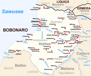
Aidabaleten is located on the coast in the northwest of the Sucos at an altitude of 113 m . It is the administrative seat of the Atabae Administration Office, which is why it is often referred to as "Atabae". The place Atabae is but in Suco Rairobo .
The settlement center consists of several contiguous places. Aidabaleten itself is located on the south bank of the Berita, with only Malebauk to the north. Aidabaleten is bordered by Talilaran to the east and Merdeka to the south . Further south are Tutubaba ( Tutu Baba ), Malarara , Fatumolin ( Fatumulin , Fatumulih ) and Fatulagung . To the south of the settlement center, the Fatumolin River flows into the Sawu Sea .
In Aidabaleten there is a primary school ( Escola Primaria Tutubaba ) and a school to prepare for secondary school. The northern coastal road, one of the most important transport links in the country, goes through the town. Bridges cross the rivers. Another country road goes east to Atabae.
Aidabalets in the interior
The village of Aidabaleten is located in the east of Sucos at an altitude of 371 m .
The Suco

The Suco has 5438 inhabitants (2015), of which 2804 are men and 2634 are women. The population density is 54.7 inhabitants / km². There are 918 households in the Suco. Over 85% of the population name Kemak as their mother tongue. More than 10% speak Tetum Prasa , small minorities Tetum Terik and Habun .
Before the 2015 regional reform, Aidabaleten had an area of 116.21 km². Now there are 99.39 km². The Suco is located in the west of the Atabae administrative office. To the east are the three other sucos of the administrative office Rairobo, Atabae and Hataz . To the south is the administrative office of Balibo with its Sucos Leolima and Sanirin , to the north is the Suco Vatuboro (administrative office of Maubara , municipality of Liquiçá ). The northern border is formed by the Lóis River , which flows into the Sawu Sea here. The Berita River flows through the north of the Sucos from Rairobo . From the southern border of Rairobo to Aidabaleten comes the Fatuburu , which joins the Hatabluturo river, which rises in Aidabaleten , and then forms the Fatumolin. This flows into the Sawusee shortly afterwards. The border to Suco Atabae is formed by the Hatoleai , which, like the rivers Meuculi and Matenua , which originate in Aidabaleten , flows eastwards. They all flow into the Nunura , which later flows back into the Lóis. On the coast in the south there are smaller lakes such as Lago Hatsun and Lago Blacau . Cape Fatu Sue forms the south-western tip of the Sucos .
In the north, near the Lóis, are the villages of Nunagbae , Tasi Mean and Kailokolaran . On the north bank of the Berita is the place Malebauk , south of the settlement center of the administrative center Aidabalaten. It lies on the coast and extends to the place Fatumolin on the north bank of the river of the same name. The northern coastal road, which follows the Lóis in Suco, first coming from Rairobo, leads along the coast from Kailokolaran. The villages Makate , Cotalaran ( Kotalaran ), Enelaran and, on Lago Blacau, Biacou ( Biacau ) are located south of the settlement center of Aidabalaten . Here the coastal road swings inland. The villages of Biahian , Meguir ( Migir , Megir ), Meletaran ( Melelaram ) and Kilibain are located on the border with Balibo . Inland, towards the border with Hataz, are the villages (from the northeast, to the southwest): Aidabaleten , Biarua , Pasmaten , Farumea ( Fatumea ), Letelaran , Hatumaleha , Damlaran , Malepun and Aikau . Besides those in Aidabaleten, there are elementary schools in Kailokolaran, Enelaran, Biacou ( Escola Primaria Biacou ), Aikau, Meguir, Farumea and Hatumaleha.
In the Suco there are the seven Aldeias Aidabaleten , Biacou , Harame , Meguir , Sulilaran , Tasi Mean and Tutubaba .
history


In Cotubaba (today Tutubaba), there was an attack on Portuguese troops by Timorese warriors in 1865 . The ruler of Atabae, together with the Liurai of Maubara, rebelled against the Portuguese colonial rulers in 1893 . Portugal responded by bombarding the coast with the 13 guns of the steamship corvette Sa de Bandeira .
In 1893 the rulers of Atabae and Maubara rebelled . Cotubaba sided with Portugal and received compensation in the form of money, buffalo and pigs from Atabae when it surrendered on July 14th. When in 1894 the empires in the west of the colony rebelled again, Cotubaba was the target of retaliation by Governor José Celestino da Silva . The place was razed to the ground in 1895 and any resident who could not escape was killed. Alexander Mau Mali, the Liurai of Cotubaba and numerous other Kemak fled to the Dutch West Timor and settled in Fatukmetan (Desa Kenebibi , Kakuluk Mesak District ), four kilometers east of Atapupu . In 1897 the Portuguese declared the kingdom of Cotubaba dissolved.
From October 1975, Indonesian troops took advantage of the chaos before the withdrawal of the Portuguese colonial rulers in East Timor and gradually occupied the districts of Bobonaro, Cova Lima and Oe-Cusse Ambeno . At the beginning of November, fighters of the FRETILIN under Aquiles Freitas Soares offered resistance in Atabae. From mid-November the Indonesians fired at Aida balets from the sea. On November 26th the East Timorese stopped the resistance and the Indonesians occupied the place on the morning of November 28th. As a result, the FRETILIN decided on the same day to declare the independence of East Timor, in the hope that the United Nations would recognize and support the new country. The hope was not fulfilled. East Timor was completely annexed in violation of international law and only regained its independence in 2002.
On December 11, 2000, an Australian INTERFET soldier was injured in an explosion in Aidabaleten. The perpetrator was suspected to be a pro-Indonesian militia .
On February 24, 2003, ten former members of a pro-Indonesian militia attacked a bus near the main town of Aidabaleten. Two people were killed and several others injured. Nepalese UN soldiers wounded an attacker who later died of his injuries. Another five were captured
politics
In the 2004/2005 elections , Manuel Mendes was elected Chefe de Suco. In the 2009 elections won Alberto Fontes and in 2016 Francisco Fontes .
Web links
- Results of the 2010 census for the Suco Aidabaleten ( tetum ; PDF; 8.5 MB)
- Results of the 2015 census for the Suco Aidabaleten (tetum; PDF)
- Seeds of Life: Suco information sheets Atabae (tetum)
Individual evidence
- ↑ a b c d Direcção-Geral de Estatística : Results of the 2015 census , accessed on November 23, 2016.
- ↑ a b List of polling stations for the parliamentary elections in East Timor 2007 (PDF file; 118 kB)
- ↑ a b UNMIT: Timor-Leste District Atlas version 02, August 2008 ( Memento from November 8, 2012 in the Internet Archive ) (PDF; 535 kB)
- ↑ Fallingrain.com: Directory of Cities, Towns, and Regions in East Timor
- ↑ Results of the 2010 census for the Suco Aidabaleten ( tetum ; PDF; 8.5 MB)
- ↑ Direcção Nacional de Estatística: Population Distribution by Administrative Areas Volume 2 English ( Memento from January 5, 2017 in the Internet Archive ) (Census 2010; PDF; 22.6 MB)
- ↑ a b Timor-Leste GIS Portal ( Memento from June 30, 2007 in the Internet Archive )
- ↑ Prostar Sailing Directions 2005 Borneo, Jawa, Sulawesi and Nusa Tenggara Enroute , p. 174, 2005.
- ↑ Jornal da Républica with the Diploma Ministerial n. 199/09 ( Memento of February 3, 2010 in the Internet Archive ) (Portuguese; PDF; 323 kB)
- ↑ a b History of Timor - Technical University of Lisbon ( Memento of the original from March 24, 2009 in the Internet Archive ) Info: The archive link has been inserted automatically and has not yet been checked. Please check the original and archive link according to the instructions and then remove this notice. (PDF; 824 kB)
- ↑ Andrey Damaledo: Divided Loyalties: Displacement, belonging and citizenship among East Timorese in West Timor , ANU press, 2018, ff. & Q = Deribate # v = onepage restricted preview in the Google book search
- ↑ Jolliffe, Jill. East Timor: Nationalism and Colonialism . Queensland: University of Queensland Press, 1978. OCLC 4833990
- ^ ETAN, When East Timor first flew its flag in defiance
- ^ Asia Pacific Solidarity Network: Sydney Morning Herald, December 12, 2000, Australian soldier injured in militia attack
- ^ US Department of State, February 28, 2005, East Timor
- ^ US Department of State, February 25, 2004, East Timor: Country Reports on Human Rights Practices
- ↑ Secretariado Técnico de Administração Eleitoral STAE: Eleições para Liderança Comunitária 2004/2005 - Resultados ( Memento of August 4, 2010 in the Internet Archive )
- ↑ Secretariado Técnico de Administração Eleitoral STAE: Eleições para Liderança Comunitária 2009 - Resultados ( Memento of August 4, 2010 in the Internet Archive )
- ↑ Jornal da República: Lista Naran Xefe Suku Eleito 2016 , December 2, 2016 , accessed on June 17, 2020.

