Allalin group
| Allalin group | |
|---|---|
| Highest peak | Alphubel ( 4206 m above sea level ) |
| location | Canton of Valais , Switzerland |
| Coordinates | 634055 / 99871 |
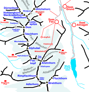
The Allalin group is a subgroup of the Valais Alps and lies between the Saas Valley in the east and Mattertal in the west. It adjoins the Mischabel group to the south, and the Allalin group is sometimes viewed as a subgroup of the Mischabel group.
While the Mischabel group to the north forms an almost straight ridge ridge running from north to south, the ridge line in the area of the Allalin group is more dissolved and the glacier basins expand further. To the south of the Allalin group, the Monte Rosa massif adjoins.
The Allalin group includes the Alphubel ( 4206 m above sea level ), Allalinhorn ( 4027 m above sea level ), Rimpfischhorn ( 4198 m above sea level ) and Strahlhorn ( 4190 m above sea level ), four four- thousanders . For the other four thousand meter peaks of the Mischabel as well as the glaciers and the huts of the Allalin group, see under Mischabel .
Literature and map
- Richard Goedeke : 4000s . J. Berg bei Bruckmann, Munich 1990, ISBN 3-7654-3401-9
- National map of Switzerland 1: 50,000, sheet 5006, Matterhorn - Mischabel
