
Altenbüren
|
Altenbüren
City of Brilon
|
|
|---|---|
 |
|
| Height : | 464 m above sea level NN |
| Area : | 13.79 km² |
| Residents : | 1365 (Dec. 31, 2019) |
| Population density : | 99 inhabitants / km² |
| Incorporation : | 1st January 1975 |
| Postal code : | 59929 |
| Area code : | 02961 |
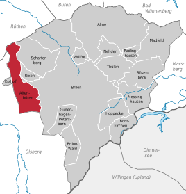  Location of Altenbüren within the urban area of Brilon
|
|
 Aerial view, looking from east to west
|
|


Altenbueren is a western district of the city of Brilon in the Hochsauerlandkreis in North Rhine-Westphalia , Germany .
geography
Altenbüren is located about 4 km west of Brilon and thus on the edge of the Brilon plateau at an altitude of about 464 m above sea level. NN . In the north of the village, the Altenbürener Forest , which belongs to the Arnsberg Forest, rises up to 560 m above sea level. NN . In the south, the heights of Langer Berg and Zwöllberg on the border with Olsberg are up to 587 m high.
The Aa , one of the headwaters of the Möhne , has its source in the locality . The Glenne , a left tributary of the Möhne, rises about 1.3 km north , and the Desmecke, a short tributary of the Ruhr , about 1 km south .
The landscape protection area Wintertal / Escherfeld extends from Altenbüren towards the Möhnetal .
The neighboring villages are the Brilon districts of Esshoff in the north-west, Rixen and Scharfenberg in the north and Brilon in the east. The town of Olsberg includes Gierskopp in the south, Olsberg itself in the south-west, and Antfeld in the west.
history
Altenbüren was first mentioned as Dorpburen in 1338 in connection with a property matter with the Count of Horhusen. Mentioned in 1376 as "Villa Buren".
Goschalk de Netelere, the Lutteke Herman and their wives Hazeke and Else sold half a hoof of land in Altenbüren (Dorpburen) to Lutteken Gobeln for 10½ to Brilon common marks . Freeman Brün gave his necessary consent to the sale and sealed the deed; The Brilon judge Rembolt the founder was also sealed.
On May 28, 1524, the town of Brilon acquired "all important parts of the property, houses, farms, meadows, real works, all majesty, wood and forest" of the village from a Volpert von Cobbenrode. Altenbüren had thus become a town village of Brilon. The town's farms were leased to farmers under the Meierrecht .
The church of Johannes Baptist must have been built during this time ; it is already shown on a map from 1535. The church is mentioned in a document from 1553. The following period, especially during the Thirty Years' War , was marked by looting and pillage, so that the population became impoverished. After the Peace of Westphalia in 1648, Altenbüren was rebuilt, mainly sheep and pig breeding.
In the course of the liberation of the peasants, the then sovereign, the Grand Duke Ludwig von Hessen-Darmstadt, decreed on November 5, 1809 that “out of the paternal care for the welfare of our entrusted subjects” all property should be transferred to the property rights of the tenants. In the course of the Hessian administrative reform of 1810, Altenbüren gained a certain degree of independence. A mayor was appointed by the authorities , who was endowed with far-reaching powers. This was supported by two elected local deputies. He could also fall back on the services of a community calculator. The only mayor of the place, Franz Henne died on March 10, 1834 at the age of 67.
When the US Army reached Brilon on March 29, 1945 , Reichsstraße 7, today B 7, was occupied by columns of the Wehrmacht and by foreign prisoners. Now the columns tried to avoid Rixen. On the night of March 30th, the head of the Gau training castle Erwitte, as a representative of the Gau leadership , appeared in the village to call up the Volkssturm and prepare the defense. A knight's cross from the Wehrmacht with two SS men took all soldiers from their vehicles without valid marching papers. These soldiers were to take over the defense with men from the Reich Labor Service who had fled from Brilon and a battalion from the Volkssturm Freikorps Sauerland from the Arnsberg district . The men of the Volkssturm were armed with old Belgian rifles and eight rounds of ammunition. Later the Volkssturm from Belecke also came. The Volkssturm from Altenbüren, all men between 16 and 70 years of age, had to start at 3 a.m. and start building road blocks and holes in the ground towards Brilon. A wide-meshed line of defense was built through the whole valley to the east. Villagers sent a message to the US commander of Brilon requesting occupation. The citizen Franz Henne even hoisted the white flag on the house. This had to be removed immediately and Henne fled into the forest to avoid a possible shooting. Women and children fled to Eßhoff or sought refuge in the black tunnel of the Windberg or in the slate tunnel of the Antfelder Ochsenberg. On the second day of Easter, April 2, the village began to be bombarded during the high mass in the church, to which only two German guns answered. Three children were wounded in the church and panic broke out. Two houses caught fire and with the exception of a few residents, the rest of the residents fled during a ceasefire. Around 3 p.m. the advance of the US troops began in three attack wedges. When defensive fire from machine guns and grenade launchers hit the attackers , massive fire began. Twenty-five houses were caught on fire and the whole village was shrouded in smoke and flames. At 5 p.m. Altenbüren was taken. The mayor Hermann Dierks was shot dead by a US soldier, although he had already surrendered and was unarmed. On April 3rd and 4th, 38 German fighters, including 18 from the Volkssturm from Sundern and Neheim , were buried in the village cemetery. 70 dead and wounded Americans are said to have been charged at the US medical center in the southern field between Brilon and Altenbüren. On April 6, the bulk of US troops moved on towards Antfeld . On April 8, a US guard shot dead Josef Schmidt in Altenbüren who was a plainclothes Wehrmacht soldier who wanted to flee Meschede to his parents in the village. A resident came across six German soldiers who had been shot in the neck in Eichholz on April 10. The dead cattle, 4 horses, 82 cattle and over 200 pigs were buried in Krämer's camp and Roßkammes Kuhle .
In the Second World War, 58 Altenbürener died as soldiers, most of them on the Eastern Front , or died in captivity.
With the municipal reorganization in North Rhine-Westphalia, Altenbüren became a district of Brilon on January 1, 1975.
Möhnekump
In the Middle Ages, the source of the Aa was surrounded by a wall and the spring water was dammed in the “Möhnekump” created in this way. Two extraction points enabled separate water supplies for humans and livestock. Today the Kump is one of the symbols of the place.
Economy and Infrastructure
traffic
Altenbüren is located on federal road 7 running in west-east direction , which crosses the Hochsauerlandkreis from Arnsberg via Meschede and Brilon to Marsberg. Altenbüren is also located on the federal highway 480 coming from Paderborn via Brilon , which further opens up the eastern Sauerland in a north-south direction via Olsberg to Winterberg. The well-developed district road 57 leads north via Scharfenberg to federal road 516 in the Möhnetal.
In local road transport, buses from Regionalverkehr Ruhr-Lippe GmbH (RLG), a subsidiary of Westfälische Verkehrsgesellschaft mbH (WVG) and Busverkehr Ruhr-Sieg GmbH (brs), a subsidiary of the railway's own WB Westfalen Bus GmbH , head towards Brilon, Olsberg and Bestwig.
The nearest railway station for rail passenger transport is Olsberg station, about 5 km away on the Upper Ruhr Valley Railway . From here trains go to Warburg with connections to Kassel and Hagen .
Public facilities
The city of Brilon runs a municipal kindergarten in Altenbüren. The upper level of the Roman-Herzog-Schule has been housed in the former primary school since autumn 2016. Attending secondary schools and the moved elementary school is only possible in Brilon or Olsberg, 4 km away.
literature
- Hugo Cramer: The district of Brilon in the Second World War 1939–1945 - reports from many employees from all over the district. Josefs-Druckerei, Bigge 1955.
References
- history
- Altenbüren on brilon.de
- Gerhard Brökel: Past Times - History from Brilon, Volume 3.
Web links
- Homepage of the place
- Altenbüren in the Westphalia Culture Atlas
Individual evidence
- ↑ Population statistics for the city of Brilon, December 31, 2019
- ^ Alfred Bruns: Inventory of the Brilon City Archives, inventory A, 1970, ed. from the State Office for Archive Maintenance, Verlag Aschendorff, Münster, p. 28.
- ^ Gerhard Brökel: Past times, story from Brilon, Volume 3, p. 103.
- ^ Hugo Cramer: The district of Brilon in the Second World War 1939-1945 . 1955, section Altenbüren, pp. 66–71.
- ^ Hugo Cramer: The district of Brilon in the Second World War 1939-1945 . 1955, roll of honor section Altenbüren, pp. 188–189.
- ^ Federal Statistical Office (ed.): Historical municipality directory for the Federal Republic of Germany. Name, border and key number changes in municipalities, counties and administrative districts from May 27, 1970 to December 31, 1982 . W. Kohlhammer, Stuttgart / Mainz 1983, ISBN 3-17-003263-1 , p. 332 .
Alme | Altenbüren | Bontkirchen | Brilon | Brilon Forest | Esshoff | Gudenhagen-Petersborn | Hoppecke | Madfeld | Messinghausen | Nehden | Radlinghausen | Rixen | Rösenbeck | Scharfenberg | Thulen | Hurled