Alzey motorway junction
| Alzey motorway junction | |
|---|---|
|
|
|
| map | |
| location | |
| Country: | Germany |
| State : | Rhineland-Palatinate |
| Coordinates: | 49 ° 46 '31 " N , 8 ° 6' 38" E |
| Basic data | |
| Design type: | Shamrock with semi-direct ramp |
| Bridges: | 2 (motorway) / 4 (other) |
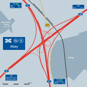
The Alzey motorway junction (short: Kreuz Alzey ) connects the two motorways A 61 (junction no. 54) and A 63 (junction no. 8) north of the Rheinhessen wine town of Alzey .
The Alzey cross, located in the area of the local community Albig , is only three-quarters of the way as a normal clover leaf . The transition from the A 63 from Mainz to the A 61 to Ludwigshafen am Rhein takes place via a long, two-lane bridge , similar to the Maltese cross construction . This type of transition was chosen because the A 63 in the direction of Kaiserslautern was not completely completed until more than three decades later in 2004. During this time, all heavy goods traffic was routed via the A 61 towards Ludwigshafen and then via the A 6 until the autobahn was finally completed . However, the importance did not decrease afterwards, because with the introduction of the truck toll and the blocking of federal road 9 between Mainz and Worms for through truck traffic , this crossing is now also increasingly used for road freight traffic.
The motorway junction also crossed the B 271 , which was downgraded to state road 401 on January 1, 2015. As well as the so-called total rail traffic between Alzey and Armsheim ( Alzey – Mainz and Rheinhessenbahn ).
The 380 kV line Rommerskirchen – Bürstadt – Hoheneck touches the cross in the northern area.
Traffic volume
The cross was used by around 87,000 vehicles every day in 2015.
| From | To | Average daily traffic volume |
Share of heavy goods traffic |
||||
|---|---|---|---|---|---|---|---|
| 2005 | 2010 | 2015 | 2005 | 2010 | 2015 | ||
| AS Bornheim (A 61) | AK Alzey | 44,200 | 42,800 | 44,300 | 22.7% | 21.7% | 20.8% |
| AK Alzey | AS Alzey (A 61) | 55,200 | 49,000 | 58,300 | 20.1% | 19.8% | 17.1% |
| AS Biebelnheim (A 63) | AK Alzey | 34,500 | 37,200 | 38,600 | 9.9% | 9.8% | 11.2% |
| AK Alzey | AS Erbes-Büdesheim (A 63) | 26,000 | 29,600 | 32,000 | 11.0% | 13.1% | 12.8% |
Web links
Individual evidence
- ↑ Manual road traffic census 2005. (PDF) Results on federal motorways. BASt Statistics, 2005, accessed on February 19, 2018 .
- ↑ Manual road traffic census 2010. (PDF) Results on federal motorways. BASt Statistics, 2010, accessed on May 30, 2019 .
- ↑ Manual road traffic census 2015. (PDF) Results on federal motorways. BASt Statistics, 2015, accessed on February 19, 2018 .
