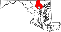
Baltimore County
![The Baltimore County Courthouse in Towson, listed on the NRHP since 1972 [1]](https://upload.wikimedia.org/wikipedia/commons/thumb/4/41/Towson_Courthouse.jpg/298px-Towson_Courthouse.jpg) The Baltimore County Courthouse in Towson, listed on the NRHP since 1972 |
|
| administration | |
|---|---|
| US state : | Maryland |
| Administrative headquarters : | Towson |
| Address of the administrative headquarters: |
Historic Courthouse 400 Washington Avenue Towson, MD 21204 |
| Foundation : | 1659 |
| Made up from: | disorganized area |
| Area code : | 001 410 |
| Demographics | |
| Residents : | 805.029 (2010) |
| Population density : | 519.4 inhabitants / km 2 |
| geography | |
| Total area : | 1766 km² |
| Water surface : | 216 km² |
| map | |
| Website : www.baltimorecountymd.gov | |
The Baltimore County is a county in the state of Maryland of the United States . At the 2010 census , the county had 805,029 people and a population density of 519.4 people per square kilometer. The county seat is Towson . The county is part of the metropolitan area of Baltimore .
geography
The county is separated from Pennsylvania to the north by the Mason-Dixon Line . It almost entirely encompasses the non-county metropolitan area of Baltimore. To the east of it, the county reaches Chesapeake Bay . Baltimore County covers an area of 1,766 square kilometers; of which 216 square kilometers (12.23 percent) are water surfaces. It borders on the following counties:
|
York County, Pennsylvania |
||
| Carroll County |

|
Harford County |
| Howard County |
Baltimore City , Anne Arundel County |
history
| growth of population | |||
|---|---|---|---|
| Census | Residents | ± in% | |
| 1900 | 90,755 | - | |
| 1910 | 122,349 | 34.8% | |
| 1920 | 74,817 | -38.8% | |
| 1930 | 124,565 | 66.5% | |
| 1940 | 155.825 | 25.1% | |
| 1950 | 270.273 | 73.4% | |
| 1960 | 492,428 | 82.2% | |
| 1970 | 621.077 | 26.1% | |
| 1980 | 655.615 | 5.6% | |
| 1990 | 692.134 | 5.6% | |
| 2000 | 754.292 | 9% | |
| 2010 | 805.029 | 6.7% | |
| 1900–1990 2000 2010 | |||
Baltimore County was formed in 1659. It was named after the English nobleman Cæcilius Calvert, 2nd Baron Baltimore (1605–1675), Lord Proprietor of Maryland.
Due to their historical significance, two buildings in the county have the status of a National Historic Landmark , the Sheppard and Enoch Pratt Hospital and Gatehouse and the Thomas Viaduct . 87 buildings and sites in the county are listed on the National Register of Historic Places (as of November 11, 2017).
Demographic data
According to the 2000 census , Baltimore County had 754,292 people in 299,877 households and 198,518 families. The population density was 487 people per square kilometer. The racial the population was composed of 74.39 percent white, 20.10 percent African American, 0.25 percent Native American, 3.17 percent Asian and 0.65 percent from other ethnic groups; 1.43 percent were descended from two or more races. Hispanic or Latino of any race was 1.83 percent of the population.
Of the 299,877 households, 30.2 percent had children under the age of 18 living with them. 49.4 percent were married couples living together, 12.8 percent were single mothers, and 33.8 percent were non-families. 27.3 percent of all households were single households and 10.1 percent had people aged 65 years or over. The average household size was 2.46 and the average family size 3.00 people.
23.6 percent of the population was under 18 years old, 8.5 percent between 18 and 24, 29.8 percent between 25 and 44, 23.4 percent between 45 and 64 years old, and 14.6 percent were 65 years or older . The median age was 38 years. For every 100 females there were statistically 90 males and for every 100 females aged 18 or over there were 86 males.
The average income of a household amounted to 50,667 USD , for a family is 59,998 USD. Males had a median income of $ 41,048 versus $ 31,426 for females. The per capita income was $ 26,167. About 4.5 percent of families and 6.5 percent of the population lived below the poverty line .
cities and communes
In Baltimore County there are no independent communities ( incorporated communities ), since the settlements are practically only suburbs of the city of Baltimore. However, these are not legally part of the city. Because of their size, the United States Census Bureau has created a number of census-designated places (CDP):
Personalities
- Richard Edwin Hoover , ophthalmologist , developed the Hoover Cane and standardized orientation and mobility training - the everyday handling of the stick by people who are blind and want to be mobile with it independently.
Individual evidence
- ↑ Extract from the National Register of Historic Places - No. 72000569.Retrieved June 30, 2011
- ↑ GNIS-ID: 1695314. Retrieved on February 22, 2011 (English).
- ^ Extract from Census.gov.Retrieved February 19, 2011
- ^ Extract from factfinder.census.gov.Retrieved February 18, 2011
- ↑ United States Census 2010.Retrieved June 30, 2011
- ↑ Listing of National Historic Landmarks by State: Maryland . National Park Service , accessed November 11, 2017.
- ↑ Search mask database in the National Register Information System. National Park Service , accessed November 11, 2017.
- ↑ Baltimore County, Maryland Datasheet with the results of the 2000 census at factfinder.census.gov
Web links
Coordinates: 39 ° 24 ′ N , 76 ° 36 ′ W


