Bieleboh
| Bieleboh | ||
|---|---|---|
|
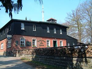
Bergwirtschaft on the Bieleboh, in the background the observation tower |
||
| height | 499.5 m above sea level HN | |
| location | Germany , Saxony | |
| Mountains | Lusatian highlands | |
| Dominance | 4.3 km → Czorneboh | |
| Coordinates | 51 ° 4 '51 " N , 14 ° 31' 17" E | |
|
|
||
| rock | Granite ; Granodiorite | |
| particularities | Lookout tower with mountain hut | |
The Bieleboh ( Upper Sorbian Bĕłobóh ) is a mountain in the Lausitzer Bergland in the eastern Free State of Saxony . The Bielebohbaude and a lookout tower are located on its summit, which is in the Beiersdorf district .
Location and surroundings
The municipality of Beiersdorf is located directly at the foot of the mountain, north of the elongated town of Cunewalde .
Origin of name
The name Bieleboh has similarities to the neighboring mountain Czorneboh . If the latter refers to the Sorbian term Čorny Bóh (black god), the Biele (“běły”) stands for white . The names suggest a reference to a pre-Christian Sorbian mythology , about which there is no reliable information. Helmold von Bosau indirectly mentioned a white god as a counterpart to the black god as the “god of happiness”. It is possible that he is identical to the Slavic sun god " Svantovit ". The mythological name of the mountain appeared - as with the Czorneboh - only in the early modern times, which is why the authenticity is disputed. In 1746 the name of the mountain was "High Forest". In the Saxon Meilenblätter, a military map series from 1780 to 1806, the mountain was entered at the same time as the "Zschernebog" (today Czorneboh) as "The Pilobogg or Beyersdorferberg". In 1841 Karl Benjamin Preusker drew a legendary stone formation on the mountain summit, which he called the “Bielybog Altar”. The name Kaspers Berg, which referred to an owner of the mountain forest, a farm owner and carter in Beiersdorf, also disappeared. In 1936 the mountain was temporarily renamed Huhberg by the National Socialists in the course of the Germanization of Sorbian field names and got its name back after 1945.
history
After 1830, shooting festivals were held on the mountain by the Kretscham host from Beiersdorf. The Upper Spree Valley Neusalza Mountain Association was founded in 1882 and began to build an arbor on the mountain, as there was already an obelisk here, but this was soon discarded and a lookout tower was planned.
In 1882 the construction of the 12 m high observation tower began. It was completed and inaugurated on May 6, 1883.
On July 2, 1910, the tower was destroyed by lightning, and it burned down completely. The Bieleboh-Verein as legal entity collected donations from the population, and the Saxon Homeland Security Regional Association designed the new design, which was 4 m higher and had a tower dome. The subsequent reconstruction was already completed on September 25 of the same year, and a solemn consecration took place. In 1994 the observation tower had to be closed because it was dilapidated. In 1998, the observation tower was repaired, which was raised by a further 5 m to its current total height of 21 m in order to achieve a better view of the treetops.
Solar phenomenon
Karl Benjamin Preusker (1786–1871) took the view that legendary rocks of Upper Lusatia served as pagan sacrificial altars in prehistoric times. Among others, he also drew the "Bielebohaltar". In March 2007 local researchers from Sohland an der Spree examined this alleged altar for its suitability for calendar solar observations. It turned out that the eye-shaped opening (devil's window) in a cavity in the stone formation allows the determination of the equinox (beginning of spring and autumn) at sunrise.
view
The tower offers a wide panoramic view of the Lusatian Mountains, but also of the volcanic mountain range of the Lusatian Mountains . Striking mountains in the field of vision are the Czorneboh , the Kottmar , the Löbauer Berg and the Oberoderwitzer Spitzberg . When the view is clear, the view extends to the Jizera and Giant Mountains in the southeast and to the eastern Ore Mountains in the west.
Paths to the summit
- A road leads from Beiersdorf to the summit. A hiking car park is located 400 m before the summit in the saddle of the Kuhberg.
- The blue- marked Zittau – Wernigerode long-distance hiking trail , also known as the Oberlausitzer Bergweg , leads over the mountain .
- A number of other marked hiking trails can also be used to climb the mountain.
source
- Information sign in the observation tower
- Between Strohmberg, Czorneboh and Kottmar (= values of our homeland . Volume 24). 1st edition. Akademie Verlag, Berlin 1974.
literature
- Karl Preusker : Glimpses into the patriotic prehistory , Leipzig 1841
- Ralf Herold: The track of light - project of the gods - sun sanctuaries of Upper Lusatia. Sohland / Spree observatory, Books on Demand, Norderstedt 2020, ISBN 978-3-7519-5892-9
Web links
Individual evidence
- ^ Miles sheets of Saxony, "Berliner Exemplar", 1804, sheet 347 and "Political Science in the Light of Our Time", No. 115, p. 917, "Geographical Meridian Determination of Saxon Places", Leipzig 1827, (designated as "Pilobogg or Beyersdorferberg")
- ↑ Karl Benjamin Preusker: Views into the patriotic prehistory. 1841, p. 189 and Plate I, No. 6
- ^ Karl Benjamin Preusker: Upper Lusatian antiquities. Gesellschaft der Wissenschaft zu Görlitz, 1828, pp. 35–51; Karl Benjamin Preusker: Look into the patriotic prehistory. Volume 3, 1844, p. 189
- ↑ Infopack 2011, Sun Sanctuaries of Upper Lusatia , observatory "Bruno-H.-Bürgel" Sohland / Spree; Ralf Herold, Sun Shrines of Upper Lusatia - The money cellar on the Löbauer Berg and its real treasure , Oberlausitzer Verlag, 2012


