Bienrode
|
Bienrode
City of Braunschweig
|
|
|---|---|
| Coordinates: 52 ° 19 ′ 1 ″ N , 10 ° 31 ′ 45 ″ E | |
| Height : | 71 m |
| Residents : | 1783 (December 31, 2017) |
| Incorporation : | March 1, 1974 |
| Postal code : | 38110 |
| Area code : | 05307 |
|
Location of Bienrode in Braunschweig
|
|
|
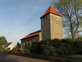
Holy Trinity Church
|
|
Bienrode is a district of the city of Braunschweig , it is located in the northern part of the city and belongs to the district of Wabe-Schunter-Beberbach .
geography
Bienrode lies on the eastern bank of the Schunter on earth-modern sediments and was a historic watermill location. North of the village, the Beberbach flows from east to west and flows into the Schunter at Wenden . Since 1934 the A2 motorway has been running to the south in an east-west direction, and to the west the Braunschweig city motorway has been running in a north-south direction. Both meet at the Braunschweig-Nord cross and form a gusset in which the Schunter branches into an old and a new arm and the mill ditch and creates a meadow landscape. East of Bienrode located at Waggum the airport Braunschweig-Wolfsburg . The railway line to Uelzen crosses the town to the east of the historical center parallel to the L625 state road, which connects Querum with the Papenteich . The Bienroder See recreation area is located on the northeastern edge of the village .
history
The district with the name Ibanroth was first mentioned in the certificate of consecration of the Magnikirche from 1031 by Bishop Branthag of Halberstadt , another mention was made in 1232 as Bigenrode . The ending -rode indicates that the district was created by clearing , whereby the meaning word usually represents a personal name. According to Blume, Casimir, Ohainski, it is not fundamentally excluded that the root word Iban was derived from yew or river, but a personal name such as Ibo or Ivo is more likely . According to the authors, the name Bigen used in 1232 cannot be derived from the previous name, but rather indicates a female first name such as Bia . So Bienrode has had two names in history.
According to Bornstedt, the place was created after 800.
The Evangelical Church of the Holy Trinity , which was built in the 12th century, is located in Bienrode . The parish in the distant neighboring town of Bevenrode , which belongs to the Königslutter provost, also looked after the community of Bienrode from 1642 to 1965. Politically, Bienrode used to belong to the Papenteich, which fell to the Principality of Braunschweig-Wolfenbüttel in 1708 .
The watermill is mentioned in 1311 as part of a donation by the von Wenden brothers to the Riddagshausen monastery . It operated until 1960.
Since it was incorporated in 1974, the district has belonged to the independent city of Braunschweig. Around 1700 people live in around 900 households in Bienrode.
Infrastructure
In Bienrode there is a sports club , the Bienrode volunteer fire brigade and a kindergarten. The primary school is on the eastern edge of the village, but it already belongs to the neighboring Waggum area.
coat of arms
The coat of arms of Bienrode was designed by Wilhelm Krieg and officially approved by the administrative president of the city of Braunschweig on February 24, 1965. It shows a gold water wheel under two gold rafters on a blue sign. One of the rafters stands for the rule of the former Welf servants of the von Wenden family . Wenden also has the rafters in the coat of arms. The colors blue and yellow represent the former state and the district of Braunschweig . The mill wheel stands for the historic water mill.
Personalities
Dieter Schidor (1948–1987), actor
Web links
- Literature about Bienrode in the catalog of the German National Library
Individual evidence
- ↑ a b Population statistics on braunschweig.de, accessed on July 29, 2018
- ↑ Herbert Blume, Kirstin Casemir and Uwe Ohainski: The place names of the city of Braunschweig (= Jürgen Udolph [Hrsg.]: Lower Saxony Place Name Book (NOB) . Volume 9 ). Publishing house for regional history, Bielefeld 2018, ISBN 978-3-7395-1161-0 , p. 29 f .
- ^ Wilhelm Bornstedt : On the document from 1031: The reasons for the entry of the 11th parish villages of St. Magni and their location in today's townscape . A settlement geography. In: Church council to Magni (ed.): St. Magni 1031–1981 . Braunschweig 1981.
- ↑ a b Luitgard Camerer , Manfred Garzmann , Wolf-Dieter Schuegraf (Ed.): Braunschweiger Stadtlexikon . Joh. Heinr. Meyer Verlag, Braunschweig 1992, ISBN 3-926701-14-5 .
- ^ Arnold Rabbow: New Braunschweigisches Wappenbuch. Braunschweiger Zeitungsverlag, Meyer Verlag, Braunschweig 2003, ISBN 3-926701-59-5 , p. 17.


