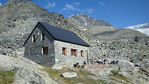
Bordierhütte
| Bordierhütte SAC refuge |
||
|---|---|---|
| location | west of the Klein Bigerhorn ; Canton of Valais , Switzerland | |
| Mountain range | Valais Alps , Mischabel | |
| Geographical location: | 631 763 / 110412 | |
| Altitude | 2886 m above sea level M. | |
|
|
||
| owner | SAC - Geneva section | |
| Built | 1927 | |
| Construction type | Refuge; Natural stone construction | |
| Usual opening times | Mid-June to mid-September | |
| accommodation | 44 beds, 28 camps | |
| Web link | Bordierhütte | |
| Hut directory | SAC | |
The Bordierhütte is 2886 m above sea level. M. high alpine refuge of the SAC Geneva section above St. Niklaus im Mischabel , Valais Alps . It is the central starting point for the summits of the Balfring range and the Nadelgrat ridge . The hut is named after the Geneva banker Pierre Bordier, who supported the construction of the hut in 1927, which originally had 52 beds.
The hut is manned during the summer months , while the kitchen, dining room and bedrooms are available for the rest of the time.
Bordierweg and route variant
The approach to the Bordierhütte is from Gasenried , requires a walking time of around 4 to 4½ hours and is high alpine with difficulty T4 . The Ried glacier has to be crossed in the upper part .
After leaving the village of Gasenried , the path leads along the «Wasserleita» Nieschwasser past the Schalbett chapel and then through the Riederwald past the fork in the path to the ridge on to Alpja at an altitude of 2099 m above sea level. M. From Alpja the marked hiking trail leads up to the Ried glacier at 2707 m above sea level. M. The flat glacial crossing is at bewarteter hut labeled with reflective rods every 20 meters. Then the path climbs again briefly to an altitude of 2886 m M. at.
At the junction you can also continue to follow the Europaweg , with the ascent up to the ridge at 2343 m above sea level. M. and then at Mittelberg at an altitude of 2562 m above sea level. M. take the turnoff to the Bordierhütte. At an altitude of 2707 m above sea level. M. meets this route variant again on the Bordierweg, before the Ried glacier is crossed.

summit
- Balfrin group
- Balfrin ( 3796 m )
- Gross Bigerhorn ( 3626 m ), pathless hike
- Klein Bigerhorn ( 3182 m ), the hut's local mountain
- Färichhorn ( 3292 m )
- Platthorn ( 3246 m )
- Gabelhorn ( 3136 m )
- Ulrichshorn ( 3925 m )
-
Needle ridge
- Nadelhorn ( 4327 m )
- Stecknadelhorn ( 4241 m )
- Hohberghorn ( 4219 m )
- Dürrenhorn ( 4035 m )
literature
- Christian Imboden: Mountains: job, calling, fate. The St. Niklaus mountain guides as pioneers of international alpinism . Rotten Verlag , Visp 2013, ISBN 3-907624-48-3 . (Chapter First camps and accommodations in the Alps known in writing for mountaineers from the lowlands, as well as high alpine huts around the Nikolaital ).
See also
Web links
Individual evidence
- ↑ SAC Club hut album 1928/1931 , 1937/1946 supplemented, graphic arts institution Brunner & Cie. A.-G., Zurich
- ↑ Bordierweg: Gasenried hiking trail to the Bordierhütte, July 21 and 22, 2015 (YouTube video clip)


