
Europaweg


The Europaweg is a high-altitude trail with difficulty T3 in the canton of Valais in Switzerland and leads under the Mischabel of the Valais Alps , starting from Grächen ( 1619 m above sea level ) and from Gasenried ( 1659 m above sea level ). via the Europahütte ( 2265 m above sea level ) to Sunnegga ( 2280 m above sea level ) above Zermatt . The high trail is 31 km long and opens up viewpoints of the Weisshorn group . The highest point is the "Grosse Graben" at 2700 m. Depending on the weather, the trail is accessible between mid-June and mid-October. It was opened in 1997 and has been signposted by Wanderland Schweiz as regional route 27 Swiss Tour Monte Rosa, stage Grächen - Zermatt since 2008 .
Europahütte
In 1999 a new mountain hut, the Europahütte, was built halfway above Randa . This is at the intersection of the Europaweg and the Domhüttenweg . It offers space for 42 people on two floors in 3 rooms with 6 beds, 1 room with 4 beds and a dormitory with 20 beds. The hut has a washroom with shower and a lounge. From the terrace there is a view of the Weisshorn group such as Weisshorn and Zinalrothorn as well as of the Matterhorn and other four-thousand-meter peaks in the Valais.
Walking times
Thanks to the Europahütte, the route can be mastered in two daily stages of 6 - 7 hours each.
Height difference
Grächen - Europahütte: ascent: ≈2600 m / descent: ≈1900 m (since the Gratberg - Galenberg road was closed in 2018)
Europahütte - Sunnegga above Zermatt: ascent: ≈1060 m (after closing the Europabrücke : ≈1520 m) / descent: ≈1060 m (after closing the Europabrücke: ≈1520 m)
Route
After leaving the village of Grächen, the path leads almost flat to Gasenried. At the junction to the Bordierhütte , the path leads steeply up to the ridge. The Europaweg now also climbs steeply to the Grathorn. The whole way over Mittelberg and the "Grossen Graben" to Galenberg had to be closed in 2018 after a major landslide. After the Grathorn, you now descend again steeply into the valley and follow the easy hiking trail significantly lower to Herbriggen. Then you have to climb again steeply to Galenberg, where you meet the original Europaweg again. Shortly before the Europahütte, a suspension bridge spans a steep ditch. After the Europahütte, the path crosses the ascent route from Randa to the Domhütte . In the Grabengufer, a 230 m long suspension bridge built in 2009, the Europabrücke , spanned a very active rockfall zone for a short time . A gallery in the Täschgufer protects against falling rocks. Soon the path reaches the Täschalp Ottafe (field name Ottawe), where the Europaweg crosses the ascent path from Täsch to the Täschhütte and the restaurant Europaweghütte Täschalp is located. The path continues towards Sunnegga without much effort. It is possible to take the Sunnegga Express underground funicular railway down to Zermatt from the Sunnegga mountain station .
In July 2011, a section of the Europahütte - Sunnegga stage (the section over the Europabrücke above Randa below the Festigletscher) was closed due to heavy rockfalls . The Grächen tourist office has created two new routes with a hiking time of almost 8 hours (mountain variant) and almost 8½ hours (valley variant) and an ascent and descent between Europahütte and Sunnegga of 1500 (mountain variant) resp. 1600 (valley variant) altitude meters recommended.
Since the end of July 2017, there has been a new, 494-meter-long suspension bridge, the Charles Kuonen suspension bridge , which spans the rockfall zone at a height of 85 m.
In 2018, the entire Grathorn - Galenberg section had to be closed due to a major landslide. After a steep descent, the path now leads significantly deeper to Herbriggen, where you climb back to the original path.
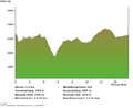
Elevation profile Europahütte - Sunnegga, path over the Europabrücke

Elevation profile Europahütte - Sunnegga, mountain variant after closing the Europabrücke

Elevation profile Europahütte - Sunnegga, valley variant after closing the Europabrücke


conditions
Recommended only for persistent and experienced hikers. It is essential to bring enough water with you.
Refreshments
Further restaurants are located in the valley towns of Herbriggen , Randa and Täsch , although the descent into the valley is necessary.
Web links
- official page
- Information about the way to Wanderland Switzerland
- http://www.wanderland.ch/de/routen/route-027.html (current link for "Wanderland")
- http://www.wanderland.ch/de/routen/route/etappe-01661.html (stages 1 to 3)
- Route description on www.wandersite.ch
Individual evidence
- ↑ Position and spelling according to SwissTopo
- ↑ New route between Europahütte and Sunnegga , accessed on July 8, 2011.
- ↑ Luzius Theler: Hiking pleasure with a gentle rocking effect - The longest suspension bridge in the world On: Neue Zürcher Zeitung from July 29, 2017