
Bulau (forest)


The Bulau is a formerly contiguous forest area northeast of Hanau . It is a very natural forest on the lower reaches of the Kinzig and, due to the richness of species, large parts of it are protected as an FFH area "Erlensee bei Erlensee and Bulau bei Hanau". There are also well-preserved sections of the Upper Germanic-Raetian Limes , the St. Wolfgang monastery ruins , the Wolfgang forestry office with the Hessian forest seed kiln and the Barbarossa spring in Bulau . Whether the name of the forest is derived from Pfahl , the Roman Limes, is still controversial today.
The forest
geography
The Bulau lies west of the last foothills of the Spessart nature park , north of the closing Ronneburger hills and northwest of the Wetterau on. It extends from the Hanau district of Wolfgang to the Rückingen district of the Hanau neighboring community of Erlensee . The Bulau includes part of the districts of Rodenbach and the Hanau district of Großauheim . The size of the FFH area is 583 ha, it includes the nature reserve Erlensee near Erlensee .
The forest is mainly characterized by the Kinzig and its tributary Lache , which fill the numerous hollows and oxbow lakes with water with their regular flooding . Part of the hollow in the ground are bomb craters , remains of the air raids on Hanau in World War II . Accordingly, the Bulau forms a natural retention area for the core city of Hanau, located downstream in a Kinzig loop, and the tributary to the Main . Together with the retention area northeast of the A 66 , an additional storage volume of 3,100,000 m³ could result with minor structural measures.
The A 66 and A 45 Dortmund - Aschaffenburg motorways divide the Bulau area. Bridges were built for some of the aisles (forest paths) to enable pedestrians , cyclists and forest vehicles to cross the motorway. To the east of the B43 , the Bulau actually still has some forest areas, such as the Rote Lache in the Wolfgang district, which are named Große Bulau on topographic maps .
flora
Due to the extensive relics of an old floodplain landscape, the Bulau is one of the most natural river systems in Hesse. As a nature reserve, large parts of the Bulau are largely excluded from forestry wood use. Regular flooding and relatively late leafing of the pedunculate oaks and hornbeams made it possible for spring bloomers in particular to settle. Broad-leaved stendellum , water sword lily , lily of the valley , forest cowslip , swamp violet and common wild garlic have been identified on rare plants . The latter provides a distinct wild garlic odor in the entire forest area in spring.
fauna
Together with the Kinzigwiesen near Erlensee and the Erlensee (16.5 ha) created by gravel and sand mining, the Bulau is one of the most biodiverse areas in the region. The lake also serves as a resting and breeding place for some water-bound species of birds including grebes , little ringed plover , tufted duck , pochard , wigeon , cormorant , gray heron and kingfisher . In the Bulau also live salamander , comb newts , yellow-bellied toads and grass snakes .
etymology
The name was derived from Pfahl , i.e. the Limes , on a map from 1728 ( Friedrich Zollmann , Comitatus Hanau ) , and the forest was referred to as Polau, Pfol- or Pfalau . The Limes runs through the Bulau, but little was known in the first half of the 18th century. Today's considerations doubt this derivation, as the name appears for the first time on the Zollmann map and was later adopted from there. The Hanau archivist Johann Adam Bernhard , a contemporary of Zollmann, already pointed out that the name in this form was never documented before the card was published; instead, the name forms Bulahe , Bulaha and Bule are documented in medieval documents .
In the early 20th century, Ernst Julius Zimmermann wanted to derive the name of Buchlohe as a local synonym for a beech forest. The Hanau historian Eckhard Meise rejects all these interpretations and prefers a derivative from Bühl , which is quite common in southern Germany. As a result of the existing hill, he favors the slight hill in the arch of the Kinzig, on which today's old town of Hanau is located. There is an analogous use of the term "Bulau" in relation to an increase in an area south of Hanau in Dreieich and Rödermark .
history
limes
Under Roman rule the Upper Germanic-Raetian Limes ran through this area , the border between the Roman Empire and "free" Germania. The architectural remains of the border fortifications are now World Heritage of UNESCO . The Limes enters in an approximately north-south course, coming from the Wetterau, into the Bulau immediately south of the Kinzig and the Rückingen fort in the Erlensee district. A few sections north of the A 45 are well preserved here, but mostly off the beaten track. It is badly damaged in the area of the motorway. Better preserved sections can only be found west of the motorway (from guard post 5/11). He crossed the double beer sump, which is still inaccessible today, in the form of a plank path, because the damp environment made it impossible to build walls and ditches in ancient times.
To the south of the double beer sump, there are again some well-preserved sections up to the renewed intersection with the A 45. The Neuwirtshaus fort located south of the motorway is well preserved . The Limes runs there, however, only faintly visible under a modern forest road. In the Neuwirtshaus area, the Limes facilities are provided with display boards. Only a few sections are visible up to the Großkrotzenburg fort . There the Limes reaches the Main , which later formed the border to the south (so-called Nasser Limes ).

Middle Ages and early modern times
In 1150 the Bulau came from royal possession to the monastery of St. Maria ad Gradus in Mainz . In 1277 Reinhard I bought the forest in exchange for other property. In 1468 the monastery of St. Wolfgang the Servites was built in the middle of the forest , but was destroyed again in the Peasants' War in 1525 . The employment history of Mainz played a role even in the late 16th century, when the Archbishop and Elector of Mainz tried, arguing that the construction of the new city Hanau by Count Philipp Ludwig II. Of Hanau-Münzenberg have against him hunting rights in the Bulau is violating preventing the construction of the new town of Hanau .
The citizens of the old town of Hanau had a traditional right to fatten pigs in the surrounding forests, especially in the Bulau . The oldest evidence for this is from 1240. A dispute with the count's chancellery from 1540 suggests that it was not a matter of guardianship , but rather a pardon from the counts to the citizens of the old town, which, however, comprised the impressive number of 350 animals. With the establishment of the Neustadt, this was initially not taken into account, which led to further complications up to a lawsuit before the Reich Chamber of Commerce. The agreement was that the shepherd of the old town would also bring animals from the new town. In Bulau, north of the Hanau-Wolfgang driveway to federal highway 43a, the district name Sausteige has been preserved. With the change of Hanau to an industrial city in the 19th century, the urban keeping and fattening of pigs had become obsolete, the last sow herder was dismissed in 1878.
The forest was used by the Counts of Hanau as a hunting area. Count Johann Reinhard III. built the small Wolfgang hunting lodge here in 1715 . The Bulau remained near Hanau until the Hanau family died out, then fell to the Landgraviate of Hesse-Kassel , which later became the Electorate of Hesse, and with this in 1866 to the Kingdom of Prussia .
Seed barrow and forestry office Wolfgang
Founded in 1884, in the forest area next to the ruins of the St. Wolfgang monastery, which gave the neighboring Hanau district its name, the Hessian seed kiln with its extensive tree seed stocks is located . It is part of the Wolfgang Forestry Office and uses the former hunting lodge of the Counts of Hanau as an administrative building. The system is available as a cultural heritage after the Hessian Denkmalschutzgesetz under conservation . The forestry office offers guided tours through the Bulau.
Cultural monuments in Bulau:

Well-preserved section of the Limes (2010)
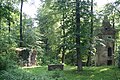
Ruins of the Wolfgang monastery

Boundary stone in the Bulau between Hanau and Erlensee: left north side (YSEN / B, to the Ysenburg court Langendiebach ), right south side (HA / NAU). Boundary stones of this kind are usually located approx. Every 20 m along a well-preserved border wall with an accompanying ditch, both of which still form the Hanau city limits today.


Second World War
During the Second World War , numerous bombs fell into the Bulau during air raids on Hanau. The explosion craters can still be seen in many places. Flak positions were also set up here in the final phase of the war .
literature
- Northwest German Forest Research Institute and Hessen Forest (Hrsg.): Portrait of Hessian natural forest reserves. Kinzigaue. Göttingen 2012, ISSN 2191-107X .
- Eckhard Meise: The “Comitatus Hanau” map and a controversy from the 18th century: where does the name “Bulau” come from? In: New Magazine for Hanau History 2010, pp. 9–43.
- Lothar Nitsche / Sieglinde Nitsche: Nature reserves in Hessen. Protect - experience - care. Volume 1 - Main-Kinzig-Kreis and City of Hanau. Published by the Naturschutzring Nordhessen eV and the Hessian Society for Ornithology and Nature Conservation eV, Main-Kinzig working group. Cognitio, Niedenstein 2002, ISBN 3-932583-05-1 , p. 91f. and 195-197.
- Gerhard Zimmermann: The most beautiful forests in Hesse. Fascinating nature discoveries. Cocon, Hanau 2017, ISBN 978-3-86314-328-2 , pp. 82-87.
Web links
Individual evidence
- ↑ hmuelv.hessen.de ( Memento of the original from April 19, 2013 in the Internet Archive ) Info: The archive link was inserted automatically and has not yet been checked. Please check the original and archive link according to the instructions and then remove this notice.
- ↑ Retention register for the Kinzig river area, pp. 30–33 ( page no longer available , search in web archives ) Info: The link was automatically marked as defective. Please check the link according to the instructions and then remove this notice.
- ↑ See Fritz-Rudolf Herrmann : The archaeological research of the Roman era in Hesse. In: Dietwulf Baatz / F.-R. Herrmann: The Romans in Hesse. Theiss, Stuttgart 1989 p. 16f. or the map of Hanau Comitatus
- ↑ a b c Eckhard Meise: The map "Comitatus Hanau" and a controversy of the 18th century: Where does the name "Bulau" come from? In: New Magazine for Hanau History 2010, pp. 9–43.
- ^ Heinrich Reimer : Hessisches Urkundenbuch. Section 2, document book on the history of the Lords of Hanau and the former province of Hanau. Vol. 1. 767-1300. Publications from the Royal Prussian State Archives, Hirzel, Leipzig 1891 No. 214 (May 4, 1240); ibid. No. 376 (December 11, 1261).
- ^ Heinrich Reimer: Hessisches Urkundenbuch. Section 2, document book on the history of the Lords of Hanau and the former province of Hanau. Vol. 1. 767-1300. Publications from the Royal Prussian State Archives, Hirzel, Leipzig 1891 No. 448 (March 2, 1270).
- ^ Heinrich Reimer: Hessisches Urkundenbuch. Section 2, document book on the history of the Lords of Hanau and the former province of Hanau. Vol. 1. 767-1300. Publications from the Royal Prussian State Archives, Hirzel, Leipzig 1891 No. 551 (November 6, 1277).
- ↑ Hans Ramge: Südhessisches Flurnamenbuch , Darmstadt 2002, p. 272.
- ↑ Helmut Puchert, Der hessische Spessart, Frankfurt 1991 = series of publications of the Forstkulturhistorisches Museum Bieber 3 = messages of the Hessian forest administration 23, p. 34.
- ↑ Eckhard Meise : Also an anniversary: the end of the Hanau pig drive in 1878. In: New magazine for Hanau history 2003 , pp. 143–231; Ernst J. Zimmermann: Hanau city and country . 3. Edition. Hanau 1919. (Reprint: 1978, ISBN 3-87627-243-2 ), p. 337ff.
- ↑ "Wolfgang at a Glance"
- ↑ State Office for the Preservation of Monuments Hesse (ed.): Rodenbacher Chaussee 10c / d-10f: Material entirety Hessische Staatsdarre Wolfgang In: DenkXweb, online edition of cultural monuments in Hessen
- ^ State Office for the Preservation of Monuments Hesse (ed.): Rodenbacher Chaussee 10a: Hessisches Forstamt In: DenkXweb, online edition of cultural monuments in Hesse
- ^ Guided tours of the Wolfgang Forestry Office
- ↑ Thomas Becker u. a .: Ground monument preservation and World War II . In: Monument Preservation and Cultural History 4/2015, pp. 25ff. (32).
Coordinates: 50 ° 8 ′ 8 ″ N , 8 ° 57 ′ 51 ″ E