Chariton County
 Chariton County Courthouse |
|
| administration | |
|---|---|
| US state : | Missouri |
| Administrative headquarters : | Keytesville |
| Address of the administrative headquarters: |
County Courthouse 306 S Cherry Keytesville, MO 65261 |
| Foundation : | November 16, 1820 |
| Made up from: | Howard County |
| Area code : | 001 660 |
| Demographics | |
| Residents : | 7831 (2010) |
| Population density : | 4 inhabitants / km 2 |
| geography | |
| Total area : | 1990 km² |
| Water surface : | 32 km² |
| map | |
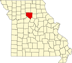
The Chariton County is a county in the US -amerikanischen State Missouri . In 2010 the county had 7,831 people and a population density of 4 people per square kilometer. The county seat is Keytesville , named after James Keyte , the city's founder.
geography
The county is located northwest of the geographic center of Missouri on the north bank of the Missouri River . It has an area of 1990 square kilometers, of which 32 square kilometers are water. The following neighboring counties border Chariton County:
| Livingston County | Linn County | Macon County |
| Carroll County |

|
Randolph County |
| Saline County | Howard County |
Protected areas
| Population development | |||
|---|---|---|---|
| Census | Residents | ± in% | |
| 1830 | 1780 | - | |
| 1840 | 4746 | 166.6% | |
| 1850 | 7514 | 58.3% | |
| 1860 | 12,562 | 67.2% | |
| 1870 | 19,136 | 52.3% | |
| 1880 | 25,224 | 31.8% | |
| 1890 | 26,254 | 4.1% | |
| 1900 | 26,826 | 2.2% | |
| 1910 | 23,503 | -12.4% | |
| 1920 | 21,769 | -7.4% | |
| 1930 | 19,588 | -10% | |
| 1940 | 18,084 | -7.7% | |
| 1950 | 14,944 | -17.4% | |
| 1960 | 12,720 | -14.9% | |
| 1970 | 11,084 | -12.9% | |
| 1980 | 10,489 | -5.4% | |
| 1990 | 9202 | -12.3% | |
| 2000 | 8438 | -8.3% | |
| 2010 | 7831 | -7.2% | |
| Before 1900 1900–1990 2000 2010 | |||
In the northwest of Chariton County's Chariton County is the Swan Lake National Wildlife Refuge , a nature reserve classified as a National Wildlife Refuge .
history
Chariton County was formed on November 16, 1820 from parts of Howard County. It was named after the Chariton River .
Demographic data
As of the 2010 census , Chariton County had 7,831 people in 3,145 households. The population density was 4 people per square kilometer. Statistically, there were 2.39 people in each of the 3145 households.
The racial the population was composed of 96.5 percent white, 2.2 percent African American, 0.3 percent Native American, 0.1 percent Asian and other ethnic groups; 0.9 percent were descended from two or more races. Hispanic or Latino of any race was 0.6 percent of the population.
22.3 percent of the population were under 18 years old, 56.1 percent were between 18 and 64 and 21.6 percent were 65 years or older. 50.8 percent of the population was female.
The median income for a household was 41,558 USD . The per capita income was $ 19,978. 14.3 percent of the population lived below the poverty line.
Localities in Chariton County
1 - partly in Howard County
2 - partly in Linn County
structure
Chariton County is divided into 15 townships :
|
|
See also
Individual evidence
- ↑ GNIS-ID: 758475. Retrieved on February 22, 2011 (English).
- ↑ a b c U.S. Census Bureau, State & County QuickFacts - Chariton County, MO. Retrieved October 19, 2012
- ^ A b National Association of Counties.Retrieved October 19, 2012
- ^ US Census Bureau - Census of Population and Housing.Retrieved March 15, 2011
- ^ Extract from Census.gov.Retrieved February 18, 2011
- ↑ Missouri Census Data Center ( page no longer available , search in web archives ) Info: The link was automatically marked as defective. Please check the link according to the instructions and then remove this notice. Retrieved October 19, 2012
Web links
Coordinates: 39 ° 31 ′ N , 92 ° 58 ′ W

