Cilaos
| Cilaos | |
|---|---|

|

|
| region | Reunion |
| Department | Reunion |
| Arrondissement | Saint-Pierre |
| Canton | Saint-Louis-2 |
| Community association | Villes Solidaires |
| Coordinates | 21 ° 8 ′ S , 55 ° 28 ′ E |
| height | 370-3,071 m |
| surface | 84.40 km 2 |
| Residents | 5,456 (January 1, 2017) |
| Population density | 65 inhabitants / km 2 |
| Post Code | 97413 |
| INSEE code | 97424 |
| Website | www.ville-cilaos.fr |
 Cilaos, July 2015 |
|
Cilaos is a French commune with 5456 inhabitants (as of January 1, 2017) in the overseas department of Réunion .
geography
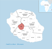
Cilaos is located in the Cirque de Cilaos basin in the center of the island, on the south side of the Massif du Piton des Neiges . The name means something like snow-capped mountain peaks . The neighboring municipalities are Les Avirons , Entre-Deux , Saint-Benoît , Saint-Leu , Saint-Louis , Saint-Paul , Salazie and Les Trois-Bassins . Striking mountains in Cilaos are the Piton des Neiges and the Col du Taibit . Forests have names such as Forêt du Grand Matarum , Forêt de la Mare à Joseph and Forêt du Tapcal .
climate
The world's largest 24-hour rainfall to date was measured in Cilaos: on 15/16. In March 1952, 1870 liters / m² of rain fell within 24 hours.
history
The settlement was founded in the 17th century by slaves who had fled the plantations into the mountains (so-called marrons ). The name is often traced back to the Malagasy expression Tsilaosa , which means "a place where one is safe". Today the community is a member of the community association CIVIS ( Communauté Intercommunale des Villes Solidaires ).
Individual evidence
- ↑ Records on www.weather.gov (with sources)
- ↑ Cilaos. (2010). In Encyclopædia Britannica. Retrieved October 4, 2010, from Encyclopædia Britannica Online: http://www.bridica.com/EBchecked/topic/117763/Cilaos
