Colorado National Monument
| Colorado National Monument | ||
|---|---|---|
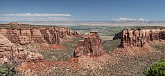
| Monument Canyon with the Independence Monument formation , Fruita, Colorado in the background | ||
|
|
||
| Location: | Colorado , United States | |
| Next city: | Grand Junction | |
| Surface: | 83.1 km² | |
| Founding: | May 24, 1911 | |
| Visitors: | 400,266 (2009) | |
The Colorado National Monument is a nature reserve of the type of a national monument in the western US state of Colorado . It covers 83 km² of a semi-desert in the area of the Uncompahgre Uplift , which in turn forms the northeast corner of the Colorado Plateau .
The area's attractiveness was recognized in 1907 by a settler named John Otto who, with the help of local authorities, convinced President William H. Taft to designate the region as a National Monument in 1911. The reserve is administered by the National Park Service . In the west joins the Black Ridge Canyons Wilderness under the administration of the Bureau of Land Management , a wilderness area and thus a nature reserve of the strictest protection category in the USA. Because of its importance for birds of prey , the National Monument has been designated as an Important Bird Area at national and state level since 2000 .
description
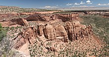
The multicolored sandstone formations of the Colorado National Monument rise more than 2,000 feet (610 m) above the Colorado River valley . Erosion from wind and water, heat and frost has formed deep breaks, steep rock faces and distinctive stone formations. The rock layers are between 1.5 billion and about 80 million years old; It owes its color spectrum, which ranges from orange to red and purple to brown, to the deposits of iron and other minerals.
The 23-mile long Rim Rock Drive leads from the west entrance, which is about 4 km from Fruita at an altitude of 1,430 meters (4,690 feet), in many turns and through tunnels steeply up to the high plateau. There you have a view over the broad valley of the Colorado to the Bookcliffs on the other side, which extend as a pink and gray striped wall as far as the eye can see. The Rim Rock Drive follows the canyon rim and from many vantage points you can see the precipice and the sandstone formations that have been given names like Balanced Rock, Window Rock, Sentinel Spire, Saddlehorn, Pipe Organ, Independence Monument, Kissing Couple , Cleopatra's Couch, Coke Ovens, Squaw Fingers, Fallen Rock, and Devils Kitchen . The road reaches its highest point near Ute Canyon View at 2024 meters (6640 feet). The east entrance, 6 kilometers from Grand Junction, is at 1,503 meters (4,930 feet)
history
The northeast of the Colorado Plateau was sparsely populated in prehistoric times by Indians of the basketmaker culture. The semi-desert climate on the high plateau did not make the region attractive, most of the finds in the region are outside the protected area near the river bank. In the Archaic Period , the Fremont culture extended to the Colorado. In historical times, today's monument belonged to the hunting ground of the Ute Indians. The latter two left a variety of petroglyphs and rock carvings in the reserve .
The colonization of the region by whites did not begin until 1881 after there had been isolated expeditions through the area and a trading post for business with the Ute had been set up in 1838 . The highlands and canyons were considered inaccessible. For the settler John Otto, who saw this fascinating landscape for the first time in 1907, it was "the heart of the world". He moved alone into the remote canyon and showered influential local politicians and the relevant authorities in Washington with letters and applications to have the area declared a national park . At the same time, he laid out hiking trails that led to the plateau and into the canyons so that other people could enjoy the landscape. He urged the residents of Grand Junctions to support him in his project by sending more letters and petitions for the protection of this land. In 1911 it was successful: on May 24, 1911, President William H. Taft declared the country a Colorado National Monument . Otto became the first ranger of the reserve. For a symbolic salary of $ 1 a month, he continued this job until 1927.
During the Great Depression , President Franklin D. Roosevelt founded the Civilian Conservation Corps as part of the 1933 New Deal , in which young unemployed volunteers under the guidance of Army officers built public infrastructure in the United States. A CCC camp played an essential role in the construction of the Rim Rock Drive , which had been planned since 1929 , the area's access road with viewpoints and picnic areas.
Ecosystems
The area has diverse habitats for animals and plants. The semi-desert of the plateau, the bare rock walls and protected shady areas in the canyons offer completely different environmental conditions. There are no year-round streams or springs.
The high plateau is geo-ecologically one of the easternmost foothills of the desert of the Great Basin . Here there are isolated Pinyon pines , the dominant plant families are cacti and succulents . The Opuntia are particularly noticeable, including the Opuntia ficus-indica . The area's largest mammals, mule deer and bighorn sheep live on the plateau . Of reptiles, there is every nine lizards and snakes in the protected area, this includes the collar iguana and the only venomous snake in the region, the midget faded rattlesnake , a subspecies of the Pacific rattlesnake on.
The rock faces are home to nine species of birds of prey, including the peregrine falcon , golden eagle , red-tailed buzzard, and turkey vulture , and some songbirds such as white-breasted swifts , pigeons, and common ravens . Cracks and caves are inhabited by several species of bats . At the foot and in the crevices there are pinyon pines and juniper bushes.
On the canyon floors there are sheltered spots where ash trees grow. Amphibians live here that you would not expect in the semi-desert environment. These include tree frogs and American paddock toads , which use temporary water for reproduction within a very short time after the rare rainfall. Most of the low-lying areas are covered with loose vegetation of sagebrush and grasses. In spring and late summer they are characterized by a variety of flowering plants. Cottontail rabbits , rock squirrels , antelope peas and chipmunks live here . Other rodents such as kangaroo rats , bush rats and pinyon mice are less common or live mostly hidden. The most important species of the canyons are helmet quail , scrub jay and pinyon jay , canyon wrens , rock wrens , Meadowlark and Grauvireos .
Through the whole territory stripes gray foxes , cougars , coyotes and bobcats , Katzenfrette ( ringtails ) and porcupines ( porcupines ) inhabit the densely wooded shares.
The National Monument
In the visitor center, which is about 4 miles from the west entrance, you can find out about the history and development of the park, about the geology and the flora and fauna by means of books, films and maps. Rangers offer lectures and guided hikes. There is a simple campsite in the north of the park. A permit is required for hikes lasting several days with overnight stays in the hinterland.
The main activity of visitors is hiking. The curvy and sometimes steep park road is also a demanding bike tour, as the gradients add up to a little over 700 meters in altitude on around 37 kilometers. In the tradition of John Otto, climbers climb the 150 m high stone formation Independence Monument on July 4th every year on Independence Day and hoist the stars and stripes .
The park suffers from development that is approaching its limits as the population in the Grand Valley doubled between the 1970s and 2000s . The curvy Rim Rock Drive , built for recreational traffic in the 1930s, is used by residents of the region on their daily commute. The Glade Park settlement, which has grown considerably in recent years, can only be reached through the protected area.
Web links
- National Park Service: Colorado National Monument (official site; English)
- National Park Service: Geology Fieldnotes for the Colorado National Monument - Geology of the Sanctuary


