
Cratzenbach
|
Cratzenbach
municipality Weilrod
|
|
|---|---|
 |
|
| Height : | 385 m above sea level NHN |
| Area : | 4.5 km² [LAGIS] |
| Residents : | 212 (Jan. 2017) |
| Population density : | 47 inhabitants / km² |
| Incorporation : | December 31, 1971 |
| Incorporated into: | Rod an der Weil |
| Postal code : | 61276 |
| Area code : | 06083 |
 Location of Cratzenbach in Weilrod
|
|

Cratzenbach is a district of the community of Weilrod in the Hochtaunuskreis in southern Hesse .
geography
Cratzenbach is located in the eastern Hintertaunus in the Taunus Nature Park . The district is located at an altitude of 320 to 500 m above sea level. NN . Neighboring towns are Hasselbach (northwest), Rod an der Weil (north), Neuweilnau (southeast) and Riedelbach (south).
history
The place was first mentioned in 1412 as Crassinbach . In 1669 the village was assigned to the newly established office Usingen . At that time, most of the area was a royal estate. In 1770 Prince Carl von Nassau-Usingen sold the estate with all the land and buildings to the village of Cratzenbach. In 1827 the first own cemetery was created. The (now a listed building standing) school was built in 1862 and visited by Cratzenbacher children up to the 1964th Today the children visit the "Grundschule im Weiltal" designed by the architect Bernd Mey in Rod an der Weil. The former town hall next to the school has been a village community center since 1957 .
As part of the regional reform in Hesse , the municipalities of Cratzenbach, Rod an der Weil and other municipalities merged on December 31, 1971 on a voluntary basis to form the municipality of Weil an der Rod, before this municipality on August 1, 1972 with several previously independent municipalities a state law was merged to form the community of Weilrod.

Culture and sights
Cultural monuments
See cultural monuments in Cratzenbach
Energy adventure tour Weilrod
In connection with the wind farm, the Wiesbaden project developer ABO Wind opened the Weilrod energy experience tour in 2015. The five-kilometer circular route begins and ends in the Cratzenbach district. Display boards, games and quiz stations provide information on the history of energy use as well as entertaining elements.

In the middle of the nameless elevation (492 m), to the right behind the Sommerberg viewed from the Dombachtal with the location of the wind turbines 1–3
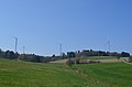
Wind turbines seen from Cratzenbach

Model of a pumped storage power plant, part of the Energy Experience Tour


Cratzenbach climbing garden
Before entering the village is the old quarry of the village. The mining of Taunus schist was abandoned. Today the facility serves as a barbecue area for the Taunus Nature Park . The steep face of the former quarry is used by the German Alpine Club as a climbing facility. For this purpose, hooks are firmly inserted.
Economy and Infrastructure

Defensive fire protection
The Cratzenbach volunteer fire brigade was founded in 1933.
Weilrod wind farm
The project developer ABO Wind planned and built a wind farm in 2014 on the wooded Feldberg-Langhals-Pferdskopf-Scholle , in the area between Riedelbach (south), Dombach (west) and Cratzenbach (north-east), on the side of the historic Rennstrasse . The construction work for the erection of the seven wind turbines (WT) of the type Nordex N117 / 2400 from the manufacturer Nordex SE with a maximum height of 199 m began in February 2014. WEA 7 was erected about 900 meters southeast of the Eichelbacher Hof . Three more wind turbines (1–3) were built to the west near the Daubhaus , which is located in a side valley of the Dombachtal . For the locations of these wind turbines, larger gray rock walls had to be removed on the Sommerberg .

As is usual with such wind energy projects in forest landscapes, larger forest areas were deforested for the 7 wind turbines with the use of wood harvesters and then cleared . In addition, the Rennstraße and the existing forest paths to the side were converted into construction roads for the transport of the building materials and system components , and the underground cables to the individual wind turbines were laid alongside the construction roads .
80 percent of the wind farm is owned by Wiesbaden-based ABO Invest AG, which markets itself as a "community wind share" and in which, according to its own statements, around 5,000 shareholders are involved. The yield data of the Weilrod wind farm are available on the Internet . According to the forecast, the wind farm should produce 49 million kilowatt hours of electricity in an average wind year . In 2015 the forecast was narrowly missed and in 2016 it was clearly missed.
Web links
- District Cratzenbach on the website of the community Weilrod.
- Cratzenbach. Local history, information. In: www.weilrod-cratzenbach.de. Cratzenbach local advisory board
- Cratzenbach, Hochtaunuskreis. Historical local dictionary for Hessen. (As of March 28, 2014). In: Landesgeschichtliches Informationssystem Hessen (LAGIS).
- Literature about Cratzenbach in the Hessian Bibliography
Individual evidence
- ↑ Cratzenbach on the website of the community of Weilrod , accessed on March 25, 2018.
- ↑ Law on the reorganization of the Obertaunus district and the district of Usingen (GVBl. II No. 330-18) of July 11, 1972 . In: The Hessian Minister of the Interior (ed.): Law and Ordinance Gazette for the State of Hesse . 1972 No. 17 , p. 227 , § 1 ( online at the information system of the Hessian state parliament [PDF; 1,2 MB ]).
- ↑ Gerstenmeier, K.-H. (1977): Hessen. Municipalities and counties after the regional reform. A documentation. Melsungen. P. 276
- ↑ Weilrod energy adventure tour. Retrieved on January 3, 2017
- ↑ Eisbär im Taunus , Frankfurter Allgemeine Zeitung of December 12, 2015,
- ↑ Profile of the Weilrod wind farm , website of ABO Wind AG. Retrieved August 8, 2017.
- ↑ Presentation ABO Wind Projekt Windpark Weilrod (PDF document)
- ↑ Citizens' Initiative Rennstraße (official homepage)
- ↑ Concept of the community wind share ABO Invest AG. Retrieved January 3, 2017.
- ↑ Yield data for the Weilrod wind farm. Retrieved January 3, 2017

Altweilnau | Cratzenbach | Emmershausen | Dark Valley | Gemünden | Hasselbach | Mauloff | Neuweilnau | Niederlauken | Oberlauken | Riedelbach | Rod at the Weil | Winches