
Dünsberg
| Dünsberg | ||
|---|---|---|
 View from the keep of Gleiberg Castle to the northwest to the Dünsberg |
||
| height | 497.7 m above sea level NHN | |
| location | near Fellingshausen ; District of Giessen , Hessen ( Germany ) | |
| Mountains | Gladenbacher Bergland | |
| Dominance | 13.9 km → Schönscheid ( 498 m , Zollbuche ) | |
| Notch height | 194 m ↓ Erbhof between Frankenbach and Wilsbach | |
| Coordinates | 50 ° 39 '2 " N , 8 ° 34' 50" E | |
|
||
| rock | Radiolarite | |
| particularities | - Dünsberg ring wall system - Dünsberg tower ( AT ) - Dünsberg telecommunications tower |
|
 View from Giessen past the castles Vetzberg (left) and Gleiberg (right) northwest to the Dünsberg |
||
.jpg) View from the south-southeast from a road between Fellingshausen and Rodheim-Bieber to the Dünsberg |
||


The Dünsberg is 497.7 m above sea level. NHN the highest mountain in the area of Giessen and Wetzlar . It is located near Fellingshausen in the Hessian district of Gießen . On it are the remains of the Dünsberg ring wall , the Dünsberg tower and the Dünsberg telecommunications tower .
geography
location
The Dünsberg rises in the southeast of the Gladenbacher Bergland . Its summit is 1.5 km northwest of the Biebertal district of Fellingshausen , 9.7 km northwest of the core city of Gießen and 12 km northeast of Wetzlar . In terms of area, the largest part of the mountain belongs to the Biebertal district of Königsberg, which extends 3.2 km (as the crow flies ) west-southwest of the mountain peak. The core town of Rodheim-Bieber in Biebertal is located south of the mountain; north-north-west is Frankenbach and north-north-east is Krumbach .
The dominance of the heavily forested Dünsberg opposite the Schönscheid ( 498 m ) in the Zollbuche ridge ( 502.4 m ) is 14 km.
Natural allocation
The Dünsberg forms in the natural spatial main unit group Westerwald (No. 32) - located near the southeastern edge of the main unit Gladenbacher Bergland (320), in the subunit Lahn-Dill-Bergland (320.0) and in the natural area Krofdorf-Königsberger Forest (320.05) - an island-like Elevation in an otherwise flat, undulating landscape, a 4th to 7th order singularity .
Flowing waters
The Dünsbergbach flows through the valley directly west of the Dünsberg as the left source brook of the Bieber , into which the Kehlbach , which rises on the eastern flank of the mountain, flows. The Bieber flows in a south-southeast direction into the Lahn , which runs in a wide curve southeast and southwest of the mountain through Gießen and Wetzlar.
The Krumbach rises on the northern slope and flows northeast through the town of the same name and flows into the Vers , which finally flows into the salt flats .
geology
The cone-shaped Dünsberg consists mainly of radiolarite (also called silica slate ), which was formed in the Carboniferous around 360 to 300 million years ago.
Protected areas
West past the Dünsberg dressed in Dünsbergbachtal parts of the protected landscape Auenverbund Lahn-Dill ( CDDA -No 378,403;. 1996 expelled; 67.2893 square kilometers in size). Parts of the fauna-flora-habitat area, grassland and forests between Frankenbach and Heuchelheim (FFH no. 5317-305; 4.9973 km²) extend through the same stream valley as far as the south-west flank of the mountain with the forest house there on the Dünsberg .
history
On the southern slope of the Dünsberg there are burial mounds with finds from the Neolithic and the Bronze Age . Therefore, a settlement in the pre-Celtic epoch is likely. Systematic fortifications of the dome can be traced back to the Urnfield Period (8th century BC).
- Celtic oppidum
The Celtic rampart installation on the mountain, Dünsberg , reached its peak during the La Tène period (around the 3rd century BC). From the settlement ( oppidum ) still testify today three concentric ring walls as remains. The rings reach a height of up to 10 meters. The outer ring encloses an area of 90 hectares . Estimates assume up to 2000 inhabitants. By using regional iron deposits, the place achieved an economic boom. During the Drusus campaigns (12 to 8 BC) the complex was conquered by the Romans. The settlement began to decline in the 1st century AD. The exact reasons are unknown.
- Alemannic hilltop settlement
After the end of the Celtic settlement, however, the Dünsberg was still used as a fortified place due to its strategically favorable location. For example, weapons finds from the 5th century are known. Finds on the eastern slope of the mountain are considered to be the remains of an Alemannic castle from the 4th or 5th century. At that time an Alemannic regulus , a petty king, was most likely seated on the mountain.
Finds from the Dünsberg have also come down to us from the Merovingian period .
- Early historical high trail
Directly past the Dünsberg a presumably prehistoric high path once passed, coming from the direction of Gießen (Glauberg ?, Schiffenberg?), Which continued on the “Lahn-Dill-Wasserscheide” or “Aar-Salzböde-Wasserscheide” to the Angelburg (Celtic settlement) , an important intersection of prehistoric and medieval long-distance trails in the Schelderwald . There was also a central pre-Christian (Celtic?) Sanctuary ( cult site ), today's Wilhelmsteine . The path was later called the Westfalenweg because it was used to get to Westphalia . From Gießen to the Zollbuche , today's Landesstraße 3047 has succeeded it. It runs almost on the same route. From the confluence of the L 3047 in the federal road 255 at the Zollbuche, the route continues north-west from the junction (towards Günterod) as a forest road.
During the Seven Years' War , in autumn 1759 or March 1761, French troops built a hill on the Dünsberg .
The district belonged to the old district of Wetzlar until January 1st, 1977.
Towers
On the summit area of the Dünsberg there are two towers close together:
Dünsberg Tower
The Dünsberg tower, built in 1899, is a brick observation tower with an attached restaurant . It was originally about 14 m high. In 1934 it was raised by 4 m and provided with a wooden hood for protection, followed by a further increase to 24 m in 1987. Inside the tower there is a historical surveying stone, which was a cornerstone of the Central European degree measurement in 1867. The view from the tower extends to the Kellerwald (north-north-east), Knüllgebirge (north-east), Vogelsberg (east-south-east), Taunus (south-west) and Westerwald (west- south- west).
Telecommunication tower Dünsberg
A steel lattice tower was built on the Dünsberg between 1964 and 1966. This was replaced from 1974 to 1978 by the Deutsche Bundespost with the 108 m high telecommunications tower in Dünsberg . The striking structure can be seen from afar.
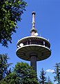
The telecommunications tower on the Dünsberg

Dünsberg Tower (2008)

Telecommunication and observation tower

Lookout tower (1904)


Worth seeing
The Dünsberg is important both as a landscape and as a cultural monument: In the local administration in Rodheim, numerous original finds from the excavations can be viewed in the KeltenKeller museum. Extensive excavations have been taking place there since 1999. To demonstrate the way of life of the Celts, a Celtic gate and other structures of a Celtic town were built by the Dünsberg Association .
Traffic and walking
Landesstraße 3047 runs across the northeast flank of the Dünsberg from Frankenbach past Fellingshausen to Krofdorf-Gleiberg in a north-northwest-south-southeast direction . As the highest mountain in the area, the Dünsberg is a popular destination for cyclists and hikers. It can be hiked, for example, on a paved access road (closed to public traffic) and over several paths and ways.
References and comments
- ↑ This dominance value presupposes that the Schönscheid measured in old table sheets ( sheet Oberscheld from 1936 ), Landkartenarchiv.de) with 498.0 m and not newly measured is actually higher than 497.7 m. If it were not, the dominance of the Dünsberg would be as much as 15.4 km (to Hülsberg and Ebersberg in the southeastern Bottenhorn plateau ).
- ↑ TK 25 provides a lower dominance than in dominances and prominence ( memento from October 19, 2014 in the Internet Archive ) (on highrisepages.de), where apparently the measurement is up to the Hirschhohl ( 503 m ).
- ↑ The notch at the Erbhof is above 302.5 m and below 305 m according to the contour lines.
- ↑ a b c Map services of the Federal Agency for Nature Conservation ( information )
- ↑ Heinz Fischer: Geographical Land Survey: The natural spatial units on sheet 124 Siegen. Federal Institute for Regional Studies, Bad Godesberg 1972. → Online map (PDF; 4.1 MB)
- ↑ Dünsberg was used for measurement , from September 5, 2014, accessed on December 3, 2014, on Mittelhessen.de
literature
- Jens Schulze-Forster: The Latène Age finds from the Dünsberg. Reports of the Commission for State Archaeological Research in Hesse 13, 2014/2015. Rahden 2015, ISBN 978-3-89646-197-1 .
- Dünsberg Association Biebertal e. V. (Ed.): The Dünsberg and the Biebertal. 3. Edition. Brühlsche Universitätsdruckerei Gießen 1989, ISBN 3-9800654-1-3 .
- Claudia Nickel; Archeology in the Gleiberger Land e. V. (Ed.): The Dünsberg near Biebertal, Gießen district - Archaeological excavations in a Celtic city. Archeology in the Gleiberger Land, Biebertal 2006, ISBN 3-00-018809-6 .
- Günter Leicht: The Dünsberg, a mountain with a history . Leicht, Günter, Biebertal 2013, ISBN 978-3-00-044212-4 .
- Michael Losse: The Lahn castles and palaces . Imhof Verlag, Petersberg 2007, ISBN 978-3-86568-070-9 .
- Christoph Schlott: Dünsberg. Celtic metropolis on the Lahn . Terra Incognita Institute, Usingen 2008, ISBN 978-3-9809751-3-1 .
Web links
- Excavations on the Dünsberg , on duensberg.de
- Archeology in the Gleiberger Land e. V. , on archaeologie-im-gleiberger-land.de
- Panorama from the Dünsbergberturm (labeling of visual targets can be activated), on panorama-photo.net