
Dettelbach
| coat of arms | Germany map | |
|---|---|---|

|
Coordinates: 49 ° 48 ' N , 10 ° 10' E |
|
| Basic data | ||
| State : | Bavaria | |
| Administrative region : | Lower Franconia | |
| County : | Kitzingen | |
| Height : | 188 m above sea level NHN | |
| Area : | 60.94 km 2 | |
| Residents: | 7295 (Dec. 31, 2019) | |
| Population density : | 120 inhabitants per km 2 | |
| Postcodes : | 97335, 97337 | |
| Area code : | 09324 | |
| License plate : | KT | |
| Community key : | 09 6 75 117 | |
| LOCODE : | DE DTB | |
| City structure: | 13 districts | |
City administration address : |
Luitpold-Baumann-Str. 1 97337 Dettelbach |
|
| Website : | ||
| First Mayor : | Matthias Bielek (Free Voters Dettelbach) | |
| Location of the city of Dettelbach in the Kitzingen district | ||
  |
||

Dettelbach is a town in the Lower Franconian district of Kitzingen with the districts Bibergau , Brück, Dettelbach-Bahnhof, Effeldorf, Euerfeld , Mainsondheim, Neuses am Berg , Neusetz, Schernau and Schnepfenbach.
geography
Geographical location
Dettelbach is located in northwest Bavaria, about 20 kilometers east of the regional center of Würzburg and about eight kilometers north of Kitzingen . The city lies on the Main .
City structure
There are 13 districts:
Neighboring communities
Neighboring communities are (clockwise from the north): Prosselsheim , Volkach , Nordheim am Main , Sommerach , Schwarzach am Main , Albertshofen , Kitzingen , Mainstockheim , Biebelried , Rottendorf and Kürnach .
Natural location
The city lies in the border area of several natural areas. The northwestern districts around Schernau are part of the Gäuf area in the northern Maindreieck (134.10), while in the southwest with the Dettelbach train station, the plateaus in the southern Main Triangle (134.11) can be found as part of the Gäuf areas in the Main Triangle (134.1). In the far north near Neuses am Berg, the Middle Main Valley (133) with the Volkacher Mainschleife (133.07) natural area protrudes into the municipality. Around Mainsondheim, on the other hand, the Schwarzacher valley widening (133.06) meets the Kitzinger Maintal (133.05).
geology
Dettelbach lies in the Franconian layered stepland on shell limestone soils. A picture of the soil conditions around Dettelbach can be obtained in a former shell limestone quarry near the city.
Protected areas
Several areas around Dettelbach have been placed under special protection by the nature conservation authorities. The Main south of the city is part of the Mainaue Fauna-Flora Habitat between Grafenrheinfeld and Kitzingen. In addition, there are areas of the Maintal bird sanctuary between Schweinfurt and Dettelbach around the districts of Neuses and Mainsondheim . Foothills of the Prosselsheimer Holz bird sanctuary can be found in the north of Neusetz. The Gäu landscape around Euerfeld, Schernau, Effeldorf and Bibergau is also a retreat for many bird species.
Only the Main floodplain between Sommerach and Köhler with its typical floodplain landscape around Neuses am Berg is a nature reserve . The western edge of the Volkacher Mainschleife conservation area is also located here . In addition to the quarry geotope south-southwest of the city of Dettelbach, there are also natural monuments . In Dettelbach the old hedge that mediated between the pilgrimage church and the city has been preserved, while in Effeldorf there are three old linden trees. Euerfeld has two groups of trees that characterize the landscape, while a single linden tree can be found in Mainsondheim. The western slope of the Main Valley near Neuses with its trees is also a natural monument.
climate
The city belongs to the Maingau climate zone, which is considered one of the driest and warmest climate zones in Germany. The annual average temperature is 7.5 to 8 ° C and the annual rainfall is around 600 millimeters.
history


Until the 19th century
The city was first mentioned in writing in 741, and the name of the city goes back to a Franconian named Tetila. The town received its town charter in 1484 from the Würzburg Prince-Bishop Rudolf II von Scherenberg . In 1503 the parish church of St. Augustine with the two unequal towers was completed. Three years later the pilgrimage church Maria im Sand was built and in 1512 the construction of the late Gothic town hall was completed. In the Middle Ages, there was a leprosarium in Dettelbach "outside the city" , which was known as the infirmary.
After the town was raised, the settlement began to be surrounded by a wall. At the same time, more and more people settled in the north in front of the Brücker Tor, so that the suburb Kühngasse was created here. However, it disappeared in the course of the passage in the Thirty Years War and was no longer mentioned in 1638.
The Dettelbach office of the Würzburg Monastery , which belonged to the Franconian Empire , fell to the Electorate of Bavaria in 1803 ( Reichsdeputationshauptschluss ) and had to be left to the Archduke Ferdinand of Tuscany in 1805 in the Peace of Pressburg to form the Grand Duchy of Würzburg . In 1814 Dettelbach finally became Bavarian and was the seat of the regional court until 1900.
As a result of the administrative reforms in the Kingdom of Bavaria , with the municipal edict of 1818 , today's municipality was created. Until 1955, the city was the seat of a Roman Catholic deanery in the diocese of Würzburg.
20th and 21st centuries
From August 30, 1900 to October 2, 1960, the five-kilometer-long Dettelbach Bahnhof – Dettelbach Stadt railway was in operation.
The city hit the headlines in February 2016 when an encryption Trojan with the Teslacrypt malware temporarily paralyzed the city administration's servers. Despite warnings from the police to the contrary, the city paid the amount demanded by the hackers.
Incorporations
In the course of the municipal reform , the municipalities of Bibergau, Brück and Effeldorf were incorporated on July 1, 1972. Mainsondheim was added on July 1, 1974. Schernau followed on January 1, 1976. Neusetz and Schnepfenbach were incorporated on January 1, 1978. With the incorporation of Euerfeld and Neuses am Berg , the series of incorporations was completed on May 1, 1978.
Jewish communities
In the past several Israelite religious communities existed in what is now Dettelbach's municipality . In the 17th century there are records of Jews in Schernau and Bibergau, they were suspected of ritual murder and had to be defended by the Würzburg prince-bishop. The Schernau community soon accepted. In Mainsondheim, the last Jews moved to the nearby Mainstockheim in 1752 .
Likewise in the 17th century, Jews had also settled in Dettelbach itself. Together with the community in Bibergau, at times over 250 people of Jewish faith lived in today's community area. While the religious community in Bibergau dissolved in the second half of the 19th century, there was a lively community life in Dettelbach until the Nazis came to power in 1933. In September 1942 the last of the Dettelbach Jews were deported to Theresienstadt .
politics
City council
After the local election on March 15, 2020 with a turnout of 69.9%, the distribution of the 20 city council seats was as follows:
| CSU | SPD | Free voters | Green | Mainsondheimer list |
Effeldorfer List |
total | |
|---|---|---|---|---|---|---|---|
| Seats | 6th | 3 | 6th | 1 | 2 | 2 | 20 seats |
| Share of votes | 29.8% | 13.9% | 34.0% | 5.2% | 9.1% | 8.0% | 100% 1 |
1 gerundet
mayor
After the runoff election on March 29, 2020, Matthias Bielek (Free Voters) was elected Mayor of Dettelbach. He received the required majority with 56.6% of the valid votes. Bielek is also a member of the city council. His predecessor was Christine Konrad, in office from October 12, 2012 to April 30, 2020.
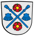
coat of arms
|
|
Blazon : “In silver, a red castle with two tin towers, in whose open gate a growing, red-clad bishop with silver undergarment, holding the golden crook in his left hand, his right hand raised in a blessing; underneath a label divided by blue and red; at the top an inclined, notched flag on a gold pole, quartered in silver and red, at the bottom a silver wave bar. " |
| Foundation of the coat of arms: The Würzburg bishop Rudolf von Scherenberg (1466–1495) asked Emperor Friedrich III. To raise Dettelbach to the city. The town charter was then awarded in 1484. An imprint of a seal is known from 1498, the representation of which already shows the coat of arms and which hardly changed in existing architectural sculptures and heraldic books in the 15th and 16th centuries. The castle with the tin towers is a reference to the term city. The red and silver flag in the small coat of arms is the Würzburg flag of the Würzburg monastery. The bishop in the coat of arms also refers to the bishopric of Würzburg , which ruled the city until the end of the old empire in 1803. The wavy bar stands as a talking symbol for the local name stream . In the years around 1920 only the small coat of arms was often used as the city coat of arms. Hupp also depicted this small coat of arms in his coat of arms book as the city arms. The coat of arms has been used since 1498. |

Bibergau coat of arms
Effeldorf coat of arms

Coat of arms of Neuses am Berg

Coat of arms of Euerfeld

Schernau coat of arms


Town twinning
Dettelbach maintains the following partnerships :
Culture and sights


The medieval city fortifications with ditches, 52 towers and five city gates are almost completely preserved in their course despite being demolished, most impressively in the northern and eastern areas. As early as the 19th century, three of the five city gates were sacrificed to road traffic. The Brücker Tor in the north and the Faltertor on the northeast corner of the city wall are very well preserved.
The narrow streets and half-timbered houses are just as medieval . The late Gothic town hall and the ensemble around the small market square below the town church are particularly worth seeing. According to a legend, the builder is said to have planned the town hall so that three people can enter the town hall at the same time without seeing each other (outside staircase, passage, from the west side). A pillory with a base and iron bracket and the inscription “for bös Leut” can be seen below the town church .
From 1616 to January 31, 2017, the pilgrimage church Maria im Sand had a Franciscan monastery to take care of the pilgrimage .
A special local pastry specialty are the nutmegs , which are cut out of the dough with loop-shaped wooden models , then baked and which are available in the two pastry shops / cafés in the city. Until well into the 70s, a pastry in the form of a was Judensau available in a local bakery, which was also gouged out with a model form.
Attractions
- Parish Church of St. Augustine
- Pilgrimage church Maria im Sand
- Late Gothic town hall
- Hornsches Spital in Spitalgasse
- The entire old town
Architectural monuments
Museums
- Museum of the home group Haslau and the surrounding area in the Kirchnerhaus
- Crafts museum in the Faltertor
- Museum "Pilgrims & Pilgrims" Dettelbach in the KUK
Mills

Dettelbach and its districts owned a particularly large number of mills until the middle of the 20th century . The two smaller brooks, Dettelbacher Bach, Brücker Bach, and Bibergauer Mühlbach, were particularly suitable for building a mill. The oldest mills were built in the middle of the 15th century, but it took a few years before they were first mentioned in a document . Population growth began in the 17th century, and more mills were built to supply the population with flour .
The great economic influence of the mills is also illustrated by two grain regulations that were issued by Prince-Bishop Julius Echter von Mespelbrunn in 1591 and 1612. The mills brought the city lords high returns in the form of interest and fulfilled an important supply function. However, the large number of mills repeatedly led to legal disputes.
In the 19th century, the small mills in Dettelbach were increasingly in economic distress due to larger ones. The mills began to be equipped with newer types of drive to increase profitability . At this time, the quarry stone houses still existing today were mostly built as the main buildings. In the first half of the 20th century, the great mill extinction began around Dettelbach. The small businesses gradually died, and today there are no more mills around the city.
At times there were four mills in the village, of which the bean mill was operated until the 1980s. There were three mills on the Dettelbacher and Brücker Bach streams north of the city, and a total of five operations were lined up along the Bibergauer Mühlbach stream. In addition, several districts also had mills, which were often simply called village mills. The mill in Schnepfenbach was the most important flour supplier for the Prosselsheim office during the Middle Ages and early modern times .
| Surname | Waters | District | Status | Key data |
|---|---|---|---|---|
| Bean mill | Dettelbach | Dettelbach | departed | First mentioned in 1567, names: "in der Bohn", "Obere or Stadtmühle", "Rabensteinmühle", abandoned in the 1980s |
| Doctor's mill | Bibergauer Mühlbach | Dettelbach | changed greatly | First mentioned in 1465, names: "Mühle an dem Gumbertsacker", "Kuffenmühle", "Doktors- oder Pfeffermühle", task unclear |
| Dorfmühle (Brück) | Dettelbach | Bridge | changed greatly | First mentioned before 1574, demolished in the 1960s |
| Dorfmühle (Euerfeld) | Schernauer Bach | Your field | changed greatly | First mentioned in 1140, name: "Euerfelder Mühle", task unclear |
| Dorfmühle (Schnepfenbach) | Dettelbach | Schnepfenbach | changed greatly | First mentioned in 1468, task unclear |
| Dozen mill | Dettelbach | Dettelbach | changed greatly | Established in 1850, abandoned in 1898 |
| Hellersmühle | Bibergauer Mühlbach | Dettelbach | receive | First mentioned in 1548, names: "Wetterichs- or old mill", "Hellersmühle", posted in 1908 |
| Deer mill | Dettelbach | Dettelbach | changed greatly | Established in 1732, names: "Dürrsmühle", "Mühle am Rinnenbach", abandoned in 1936 |
| High mill | Schernauer Bach | Schernau | changed greatly | unclear, names: "Schernauer Mühle", "Dorfmühle", task unclear |
| Pebble mill | Dettelbach | Dettelbach | changed greatly | First mentioned in 1567, name: "Weihersmühle", task unclear |
| Küffleinsmühle | Dettelbach | Dettelbach | changed greatly | First mentioned in 1567, name: "Küffleinsmühle", abandoned in 1927 |
| Kühngassenmühle | Bibergauer Mühlbach | Dettelbach | receive | First mentioned in 1591, names: "Kühngassenmühle", "Dienenmühle", abandoned in the 1970s |
| Lamprechtsmühle | Dettelbach | Dettelbach | receive | First mentioned in 1465, names: "Hederleinsmühle", "Schederleinsmühle", "Mittelmühle", abandoned in 1932 |
| Barrier mill | Bibergauer Mühlbach | Dettelbach | changed greatly | First mentioned in 1591, name: “2. Mill towards Bibergau ”, task unclear |
| Climbing mill | Dettelbach | Bibergauer Mühlbach | receive | First mentioned in 1591, name: "Heidnersmühle", posted in 1906 |
| Under mill | Dettelbach | Dettelbach | changed greatly | First mentioned in 1567, names: "Unterstadtmühle", "Untermühle am Maintor", abandoned in 1941 |
walks
The Pilgervolk Sculpture Trail, opened in 2005, leads from the old town to the pilgrimage church.
Along the city wall , a path runs around the old town from the south (entrance from the state road 2450) to the Faltertor in the northeast to the city church in the center.
A legend and myth trail, opened in 2009, leads southwest of state road 2450 from Egerländer Straße through the vineyards to the Am Spielberg street. Over the course of two kilometers, grape varieties, locations of the Dettelbacher wineries, windbreak hedges, impact and sliding slopes of the Main, ecological viticulture and interesting facts (legends and myths) from Dettelbach are presented on twelve display boards. The boundary stone "Sieben-Köpf-Marter" after half of the way represents the legend of the beheading of seven rebels on its narrow side.
Dettelbacher Muskatzine

In the heyday of the Dettelbach pilgrimage, at the beginning of historicism , the confectioner from Dettelbach, Urban Degen, thought about what he could offer the pilgrims. He composed a pastry made of nutmeg and several spices and named it Muskazine . Since Urban Degen was very vain and was considered the best-dressed confectioner in the area, he gave the new biscuits the shape of a tie bow. He carved a wooden shape with which he made the dough the shape of the muscatel. Urban Degen invented the Muskatzinen in 1850. Gerald Degen: and before his death he passed the recipe on to his Dettelbacher colleagues on the condition that the original recipe only be passed on to their direct successors. The Dettelbacher Muskazine is a pastry specialty from Dettelbach, which is designed in the shape of a bow tie . Its name comes from the main ingredient nutmeg . Other ingredients are honey, almonds, marzipan , sugar, nuts, flour and other spices ( cloves , cinnamon , cardamom ) and baking powder. Muscazines are made all year round.
Economy and Infrastructure
economy
In addition to the main town, the districts also operate wine, the most famous location being the Neuseser Glatzen . Other important agricultural products are fruit, sugar beet and, increasingly, rapeseed and sunflowers for oil production.
The Mainfrankenpark , located on the border with the Würzburg district, belongs to Dettelbach and has, among other things, a multiplex cinema , a 3-D cinema (in the former IMAX building), a bowling center and various restaurants. In addition to the leisure facilities, the Mainfrankenpark offers commercial space for various companies. Another, older industrial area (industrial area east) is right outside the gates of the city (on the Main). Mainly building materials are produced here.
Tourism is also of importance, with the beginning of the pilgrimages to Maria im Sand , which has an unbroken 500-year tradition. Today, however, cycle tourists and wine lovers are gaining in importance.
Viticulture
Today, Dettelbach is an important wine-growing area in the Franconian wine-growing region . A total of two vineyards exist around the village, the wine has been marketed under the names Dettelbacher Berg-Rondell and Dettelbacher Sonnenleite since the 1970s. In addition, there is a large area of its own with the Dettelbacher Honigberg. Dettelbach is part of the range Volkacher Main loop until 2017, the wineries in area were Maindreieck summarized. The limestone soils around Dettelbach are also suitable for growing wine, as is the location in the Maingau climate zone, which is one of the warmest in Germany.
.jpg)
The people around Dettelbach have been growing wine since the early Middle Ages . The Franconian settlers probably brought the vine to the Main in the 7th century. In the Middle Ages, the region was part of the largest contiguous wine-growing region in the Holy Roman Empire. The people mostly operated part-time viticulture for self-sufficiency , at the same time export centers were already emerging, especially along the Main.
Viticulture in Dettelbach first became tangible at the end of the 15th century, when the Würzburger Salbuch recorded a total of “70 Acker Weingarten” in Dettelbach. Up until the end of the Middle Ages there were probably almost 500 hectares of vines around the place. With the Thirty Years War , the number sank drastically, so that in 1638 only around 180 hectares were planted with vines. Dettelbach also exported the wine, but it was mostly grown on small areas for personal use.
Viticulture experienced a major decline after secularization at the beginning of the 19th century. Above all, locations with less favorable climatic conditions were completely abandoned. In addition, the emergence of pests such as phylloxera made cultivation difficult . In 1914, only 56 hectares around Dettelbach were occupied with vines. The Franconian wine-growing region was not able to consolidate again until the second half of the 20th century. The use of fertilizers and improved cultivation methods had contributed to this, as had the organization in cooperatives and the land consolidation of the 1970s.
With over 200 ha (2017, main town and districts) or 93 ha (1980, main town), Dettelbach is today the seventh largest wine-growing community in the Franconian wine-growing region. The most obvious symbol for the resurgence of viticulture is the so-called Old Town Wine Festival , which is celebrated every year at the end of June in front of the town hall and is one of the larger festivals in the growing area. In addition, the hedgerows of the local wineries characterize the place in the spring and summer months.
| Vineyard | Size 1993 | Compass direction | Slope | Main grape varieties | Great location |
|---|---|---|---|---|---|
| Mountain roundabout | 80 ha | southeast | 25-50% | Silvaner , Müller-Thurgau | Dettelbacher Honigberg |
| Sonnenleit | 75 ha | south | 20-25% | Müller-Thurgau | Dettelbacher Honigberg |
tourism
Dettelbach is a popular holiday destination in the Kitzingen district. In order to further strengthen tourism in the region, the hospitable five were founded, to which, in addition to Dettelbach, the municipalities of Gerolzhofen , Volkach , Kitzingen and Iphofen also belong. The city has 350 beds in hotels, private rooms and holiday apartments.
traffic
State road 2450 crosses Dettelbach. The Dettelbach train station is located a little outside the main town near the state road 2450 on the Nuremberg – Würzburg railway line .
The former Dettelbach Bahnhof – Dettelbach Stadt railway line via Bibergau was dismantled . Between Bibergau and Dettelbach Stadt there is a direct, asphalted, agricultural path that runs through the valley, which is closed to vehicle traffic on Sundays and can then be used as a hiking trail.
The city lies on the Main . The A 3 motorways (Dettelbach Ost and West exits) and A 7 run along the boundary . These meet at the Biebelried Cross . The federal highway 8 and the federal highway 22 are also nearby .
Dettelbach is connected to the Mainsondheim district via the Main ferry Mainsondheim .
The Franconian Marienweg runs through Dettelbach .
schools
In Dettelbach there is a primary and secondary school, the Rudolf-von-Scherenberg elementary school and a regional secondary school, the state secondary school Dettelbach. The next high schools are the Egbert-Gymnasium in Schwarzach (six kilometers) and the Armin-Knab-Gymnasium in Kitzingen (ten kilometers).
Sports
Dettelbach has several tennis courts, a soccer field, a sand court for beach volleyball, a multi-purpose hall with a bowling alley and a swimming pool. On the opposite side of the Main in the incorporated town of Mainsondheim there is an 18-hole golf course. The flat bike paths on the banks of the Main are also often used by inline skaters , on the Main you can go with rented canoes (canoe rental). Dettelbach has gained national fame through the annual U16 junior indoor tournament with numerous youth teams from clubs in the 1st and 2nd Bundesliga. After the Freewy Cup in Lübbecke, the tournament is the best-attended tournament in Germany in this age group.
Pictures from Dettelbach

Remains of the city fortifications
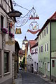
Falterstrasse

Catholic parish church of St. Augustine

Brücker Gate
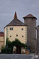
Faltertor


Personalities
Honorary citizen
- 1895: Friedrich Roth (1847–1927), pastor from 1885 to 1895 in Dettelbach
- 1896: Luitpold Baumann (1844–1919), member of parliament and mayor, who provided the community with the railway connection
- 1925: Konrad Lippert (1847–1927), pastor from 1896 to 1925 in Dettelbach
- 1958: Burkard Weissenberger (1885–1962), pastor from 1937 to 1958 in Dettelbach
Associated with Dettelbach
- Wilhelm von Grumbach (1503–1567), imperial knight and bailiff of Dettelbach and Stadtschwarzach 1528–1531 and 1541–1544
- Eucharius Sang (around 1556–1620), auxiliary bishop and writer, wrote the so-called Miracle Book of Dettelbach
- Augustin Bossi (1740–1799), Italian plasterer, lived in Dettelbach
sons and daughters of the town
- Paulus († 1505), Benedictine abbot in Münsterschwarzach
- Johann Molitor (also Johannes VII. Molitor, 1576–1639), provost of Heidenfeld and Triefenstein
- Maurus Faber (gen. 1646–1661), Abbot of St. Stephan and Rector of the University of Würzburg
- Johann Zacharias Fürst (? –1701), physician and personal physician to the Elector of Trier
- Johann Simon Bauermüller (1679–1737), physician and anatomist
- Aloys Schedel (1766–1827), district forester, natural scientist and natural history collector
- Franz Christoph von Rothmund (1801-1891), surgeon
- Michael Schmerbach, called "Bachel" (1824–1886), doctor, draftsman, writer and editor
- Josef Kram (1852–1874), dialect poet
- Georg von Breunig (1855–1933), Bavarian Minister of State for Finance
- Michael Adalbero Fleischer CMM (1874–1963), bishop in South Africa
- Rudolf von Roman (1893–1970), born in Schernau, general of the artillery
- Franz Erasmus Spannheimer (1946–2019), composer and organist
- Simone Michel-von Dungern (* 1965), born in Mainsondheim, classical archaeologist and museum director
- Ela Weber (* 1966), German-Italian announcer and presenter
- Susanne Glanzner (* 1977), writer
- Oliver Kienle (* 1982), screenwriter and director
literature
- Hans Ambrosi, Bernhard Breuer: German Vinothek: Franconia. Guide to the vineyards, winegrowers and their kitchens . Herford 2 1993.
- Hans Bauer: The history of viticulture in Dettelbach . In: City of Dettelbach (Ed.): Dettelbach. 1484-1984. Festschrift and small characteristics of a 500 year old city . Dettelbach 1984. pp. 116-122.
- Hans Bauer: Legends and stories from Dettelbach . Publishing house Dr. Josef H. Röll, Dettelbach, 1999, ISBN 3-89754-143-2 .
- Peter Schneider: Between the Main and Steigerwald (= Mainfränkische Heimatkunde 1) . Würzburg 1955.
Web links
- City administration
- District: Neuses am Berg
- District: Euerfeld
- Dettelbach . In: Meyers Konversations-Lexikon . 4th edition. Volume 4, Verlag des Bibliographisches Institut, Leipzig / Vienna 1885–1892, p. 729.
- Dettelbach: Official statistics of the LfStat
Individual evidence
- ↑ "Data 2" sheet, Statistical Report A1200C 202041 Population of the municipalities, districts and administrative districts 1st quarter 2020 (population based on the 2011 census) ( help ).
- ↑ Mayor. City administration Dettelbach, accessed on June 6, 2020 .
- ↑ Bayerische Landesbibliothek Online , accessed on February 28, 2012
- ↑ see data from the Society for Leprosy on Leprosoria in Today's Bavaria, accessed on February 26, 2017 ( Memento of the original from February 6, 2015 in the Internet Archive ) Info: The archive link was automatically inserted and not yet checked. Please check the original and archive link according to the instructions and then remove this notice. More precise data on place and time are missing.
- ^ Spiegel-Online: Tesla-Crypt: Extortion with Trojans - City administration paid ransom , accessed on March 3, 2016.
- ^ Wilhelm Volkert (ed.): Handbook of Bavarian offices, communities and courts 1799–1980 . CH Beck, Munich 1983, ISBN 3-406-09669-7 , p. 497 .
- ^ Federal Statistical Office (ed.): Historical municipality directory for the Federal Republic of Germany. Name, border and key number changes in municipalities, counties and administrative districts from May 27, 1970 to December 31, 1982 . W. Kohlhammer GmbH, Stuttgart and Mainz 1983, ISBN 3-17-003263-1 , p. 747 and 748 .
- ^ City of Dettelbach - election results 2020
- ↑ Michael Mösslein: Mr .
- ^ House of Bavarian History: Dettelbach coat of arms , accessed on July 4, 2019.
- ^ Franciscans: The end after 400 years
- ↑ Quoted from Christoph Daxelmüller : Antisemitism in Franconia - Franconian antisemitism? (Lecture from November 12, 2009)
- ^ Bauer, Hans: Dettelbach . P. 148.
- ↑ Cafe Kehl: The Dettelbacher specialty "Muskatzine"
- ↑ Peter Achtmann: Achtmann. Dettelbach - At the Faltertor. Muscat bakery since 1880 . Leaflet from around 2015.
- ^ Bauer, Hans: The history of viticulture in Dettelbach . P. 117.
- ^ Ambrosi, Hans (among others): German Vinothek: Franconia . Pp. 50-52.
- ↑ Altstadt-Weinfest-Dettelbach: program and information , accessed on May 24, 2019.
- ↑ Government of Lower Franconia: Vineyards in Bavaria broken down by area ( Memento of the original from July 28, 2018 in the Internet Archive ) Info: The archive link was automatically inserted and not yet checked. Please check the original and archive link according to the instructions and then remove this notice. , PDF file, accessed May 16, 2019.
- ^ Ambrosi, Hans (among others): German Vinothek: Franconia . P. 237.
- ↑ Ignaz Denzinger : Historical-topographical description of the city of Dettelbach . Archive of the Historical Association of Lower Franconia and Aschaffenburg, 14, 2, Würzburg 1858, pp. 87–90 ( digitized version )
- ^ Schneider, Peter: Between Main and Steigerwald . P. 190.

Cities: Dettelbach | Iphofen | Kitzingen | Mainbernheim | Market wide | Marktsteft | Prichsenstadt | Volkach
Markets: Abtswind | Hostage wind | Großlangheim | Kleinlangheim | Einersheim Market | Obernbreit | Rüdenhausen | Schwarzach am Main | Home of being | Wiesentheid | Willanzheim
Municipalities: Albertshofen | Biebelried | Buchbrunn | Castell | Mainstockheim | Martinsheim | Nordheim am Main | Rödelsee | Segnitz | Sommerach | Sulzfeld am Main | Wiesenbronn
Bibergau | Bridge | Dettelbach | Dettelbach train station | Effeldorf | Euerfeld | Mainsondheim | Neuhof | Neuses am Berg | New set | Schernau | Schnepfenbach | Sulzhof