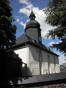
Drognitz
| coat of arms | Germany map | |
|---|---|---|

|
Coordinates: 50 ° 35 ' N , 11 ° 34' E |
|
| Basic data | ||
| State : | Thuringia | |
| County : | Saalfeld-Rudolstadt | |
| Fulfilling municipality : | Kaulsdorf | |
| Height : | 510 m above sea level NHN | |
| Area : | 24.02 km 2 | |
| Residents: | 615 (Dec. 31, 2019) | |
| Population density : | 26 inhabitants per km 2 | |
| Postal code : | 07338 | |
| Area code : | 036737 | |
| License plate : | SLF, RU | |
| Community key : | 16 0 73 107 | |
| Community structure: | 5 districts | |
| Association administration address: | Strasse des Friedens 27 07338 Kaulsdorf |
|
| Mayor : | Henry Drogatz | |
| Location of the municipality of Drognitz in the Saalfeld-Rudolstadt district | ||
Drognitz is a municipality in the Saalfeld-Rudolstadt district in Thuringia . Fulfilling community for Drognitz is the church Kaulsdorf .
geography
The community is located in the Thuringian Slate Mountains-Obere Saale nature park above the Hohenwarte reservoir . Drognitz and the villages of the unified community are to the left of the Saale on a high plateau of the Southeast Thuringian slate mountains. These areas have a high proportion of fine soil and a high humus content and therefore have good soil fertility. The heights to the after the Saale dam and its bays are passed around the plateau with forest. The villages can be reached by traffic via the L 1100 and L 2366.
Community structure
The municipality is divided into a total of five districts (incorporation dates in brackets):
- Drognitz
- Lothra (April 6, 1994)
- Neidenberga
- Neuenbeuthen (January 1, 1997)
- Reitzengeschwenda (January 1, 1997)
history
The place is first mentioned on April 16, 1120 in a deed of donation. The Sorbs settled the square village much earlier. The place belonged to the electoral office of Ziegenrück until 1815 and after its assignment, decided at the Congress of Vienna , came to the Prussian district of Ziegenrück , to which the place belonged until 1945.
Incorporations
Lothra was incorporated on April 6, 1994. With the dissolution of the administrative community Obere Saale on January 1, 1997 Neuenbeuthen and Reitzengeschwenda were incorporated. At the same time, Kaulsdorf became a fulfilling community for Drognitz.
Population development
Development of the population (from 1997: as of December 31st) :
|
|
|
|
- Data source from 1997: Thuringian State Office for Statistics
politics
Municipal council
The local council from Drognitz consists of 8 members of a group of voters ( CDU / voter community) (status: local council election on May 26, 2019 ).
mayor
The honorary mayor Henry Drogatz was elected on January 1st, 2017.
Culture and sights
- Village church with interesting furnishings
- Camping site "Hopfenmühle": below Drognitz, directly at the Hohenwartetalsperre (artificially dammed Saale)
Sons and daughters of the church
- Moritz August von Obernitz (1743–1823), born in Neidenberga, Prussian major general
- Hans Lippold (1932–1980), German botanist
Web links
Individual evidence
- ^ Population of the municipalities from the Thuringian State Office for Statistics ( help on this ).
- ^ Federal Statistical Office: Municipalities 1994 and their changes since 01.01.1948 in the new federal states. Metzler-Poeschel, Stuttgart 1995, ISBN 3-8246-0321-7 .
- ↑ a b StBA: Changes in the municipalities, see 1997
- ^ Wolfgang Kahl : First mention of Thuringian towns and villages. A manual. 5th, improved and considerably enlarged edition. Rockstuhl, Bad Langensalza 2010, ISBN 978-3-86777-202-0 , p. 61.
- ^ A b Michael Rademacher: German administrative history from the unification of the empire in 1871 to the reunification in 1990. Ziegenrück district. (Online material for the dissertation, Osnabrück 2006).
- ^ Thuringian State Office for Statistics - 2019 municipal council election in Thuringia, final result: Drognitz
- ^ Thuringian State Office for Statistics - Mayoral elections in Thuringia, Drognitz


