
Edertal
| coat of arms | Germany map | |
|---|---|---|
.png)
|
Coordinates: 51 ° 10 ′ N , 9 ° 6 ′ E |
|
| Basic data | ||
| State : | Hesse | |
| Administrative region : | kassel | |
| County : | Waldeck-Frankenberg | |
| Height : | 226 m above sea level NHN | |
| Area : | 115.73 km 2 | |
| Residents: | 6210 (Dec. 31, 2019) | |
| Population density : | 54 inhabitants per km 2 | |
| Postal code : | 34549 | |
| Primaries : | 05623, 05621 | |
| License plate : | KB, FKB, WA | |
| Community key : | 06 6 35 009 | |
| LOCODE : | DE EQL | |
| Address of the municipal administration: |
Bahnhofstrasse 25 34549 Edertal |
|
| Website : | ||
| Mayor : | Klaus Gier ( independent ) | |
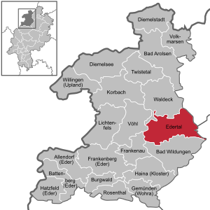
| Location of the community of Edertal in the Waldeck-Frankenberg district | ||
  |
||

Edertal is a municipality located on the Eder in the northern Hessian district of Waldeck-Frankenberg .
The community is known nationwide through the Edersee and the Kellerwald-Edersee Nature Park , which includes the Kellerwald-Edersee National Park .
geography
location
The municipality of Edertal is located about 30 km (as the crow flies ) southwest of Kassel on the north and north-east edge of the Kellerwald and spreads on the south bank of the Edersee and east and south-east of its dam. It is located with a few parts of the community in the Kellerwald-Edersee nature park or, for the most part, just outside of its eastern boundary; Part of this nature park is the Kellerwald-Edersee National Park .
The Eder flows through the Edertal in a north-west-south-east direction; The nets flow into this - viewed downstream - at the district of Lieschensruh (part of the district of Mehlen) , at the district of Bergheim the Wesebach and not far north of it the Böhner Bach . The Affolderner See , which is located not far southeast of the Edersee in the municipality, is a reservoir that, like the Edersee, is used for energy generation and local recreation.
The highest mountain not far from the municipality of Edertal is the Traddelkopf , which at 626 m above sea level. NN highest mountain in the Kellerwald-Edersee National Park. The Peterskopf ("energy mountain") are widely known because it is the location of the Waldeck pumped storage power plant with its upper basin, the Uhrenkopf with a view of the Eders barrier wall and the Hammerberg with the Edersee wildlife park .
Neighboring communities and districts
The 11,740 hectare area of the municipality of Edertal borders on the cities of Waldeck and Naumburg ( district of Kassel ) in the north, Fritzlar ( Schwalm-Eder district ) in the east, Bad Wildungen in the south and Frankenau and the municipality of Vöhl in the west (all three in the district Waldeck-Frankenberg).
Community structure
The community of Edertal today consists of 13 districts :
|
The seat of the municipal administration is in Giflitz. Together with the neighboring municipality of Bergheim to the northeast, this place forms the community center and is accordingly shown as the basic center in the regional plan.
geology
The area belongs to the foothills of the Rhenish Slate Mountains . The starting rock here is mainly slate and greywacke .
history
Early history
In 1908 reindeer antlers and other objects were found in a clay pit near Buhlen during road construction work . In 1967 this was examined again, whereby the assumption was confirmed that in the area of today's Buhlen a settlement of the Neanderthals existed. This site is one of the most anthropologically significant settlement sites for Neanderthals in Germany today. The numerous animal bones, wedge knives and bone artifacts found there are unique .
Church building
On July 1, 1971, the municipality of Edertal was re-established as part of the regional reform in Hesse through the voluntary merger of the previously independent municipalities of Bergheim and Giflitz. Gellershausen was added on October 1, 1971. Affoldern, Anraff, Böhne, Bringhausen, Buhlen, Hemfurth-Edersee, Königshagen, Mehlen and Wellen followed on December 31, 1971. The series of incorporations was completed on January 1, 1974 with the incorporation of smaller ones by virtue of state law.
politics
Community representation
The local elections on March 6, 2016 produced the following results, compared to previous local elections:
| Parties and constituencies |
% 2016 |
Seats 2016 |
% 2011 |
Seats 2011 |
% 2006 |
Seats 2006 |
% 2001 |
Seats 2001 |
||
|---|---|---|---|---|---|---|---|---|---|---|
| SPD | Social Democratic Party of Germany | 33.1 | 10 | 44.8 | 14th | 46.5 | 14th | 49.5 | 15th | |
| CDU | Christian Democratic Union of Germany | 20.0 | 6th | 20.2 | 6th | 27.8 | 9 | 25.6 | 8th | |
| FWG | Free community of voters | 19.0 | 6th | 13.7 | 5 | 17.5 | 5 | 17.1 | 5 | |
| WE | WE Edertaler | 10.7 | 3 | 15.5 | 5 | - | - | - | - | |
| GREEN | Alliance 90 / The Greens | 9.3 | 3 | - | - | - | - | - | - | |
| FDP | Free Democratic Party | 7.8 | 3 | 5.8 | 2 | 8.1 | 3 | 7.8 | 3 | |
| total | 100.0 | 31 | 100.0 | 31 | 100.0 | 31 | 100.0 | 31 | ||
| Voter turnout in% | 62.8 | 64.3 | 61.8 | 65.3 | ||||||
mayor
In November 2012 the independent Klaus Gier was elected as the new mayor.
coat of arms
The coat of arms was awarded on February 16, 1976 by the Hessian Ministry of the Interior.
Blazon : "In the golden field above the blue wave shield, the eight-pointed, black Waldecker star."
The coat of arms symbolizes on the one hand the historical affiliation to Waldeck, on the other hand the importance of the Edersee with the dam and power station for the present.
The execution and design of the coat of arms was in the hands of the Bad Nauheim heraldist Heinz Ritt .
Traffic and walking
The federal road 485 runs through Edertal between Korbach and Bad Wildungen , from which state road 3086 branches off in the district of Mehlen through Affoldern and past Affolderner See to Edersee ; both streets are part of the German half-timbered street .
The municipality is located on a disused section of the Wabern – Brilon Wald railway line , on which the Ederseebahn cycle path has now been laid, and on the Ederauen cycle path . The hiking trails Diemel-Ederweg , Ederauen-Erlebnispfad , Ederhöhenweg , Kellerwaldsteig , Lulluspfad and Urwaldsteig Edersee also lead through .
The following cycle paths lead along the Eder and on the south bank of the Edersee :
- The 180 km long Eder cycle path begins in the Rothaargebirge in North Rhine-Westphalia and is called here Ederauenweg . The largest part leads through Hesse and is then called the Eder cycle path . It follows the course of the Eder to where it flows into the Fulda (river) near Guxhagen .
- A cycle path on the Orange Route connects the cities of Diez , Nassau , Braunfels , Dillenburg , Siegen and Bad Arolsen , which have been closely linked to the royal family of the Netherlands for many centuries , over around 400 kilometers.
- The Hessian long-distance cycle route R5 (North Hesse route Eder-Fulda-Werra) leads over 220 km from Willingen in the Upland along the southern shore of the Edersee , via Homberg (Efze) and Rotenburg an der Fulda to Wanfried an der Werra .
- The Hessian long-distance cycle route R6 (from Waldecker Land into the Rhine Valley) begins in Diemelstadt in northern Hesse and runs with a total length of approx. 380 km to Lampertheim in southern Hesse.
Architectural monuments and sights
- Edertalsperre and Edersee
- Love island
- Affolderner See
- Kellerwald-Edersee Nature Park
- In the Bergheim part of the municipality there is Bergheim Castle , which was rebuilt in the classicist style in 1785/86 for Count Josias II von Waldeck-Bergheim . The monument, which is important in terms of cultural history, is currently unused and empty.
- Evangelical Church Affoldern
Individual evidence
- ↑ Hessian State Statistical Office: Population status on December 31, 2019 (districts and urban districts as well as municipalities, population figures based on the 2011 census) ( help ).
- ^ Municipal reform in Hesse: mergers and integrations of municipalities from June 21, 1971 . In: The Hessian Minister of the Interior (ed.): State Gazette for the State of Hesse. 1971 No. 28 , p. 1117 , item 988; Para. 3. ( Online at the information system of the Hessian State Parliament [PDF; 5.0 MB ]).
- ↑ Law on the reorganization of the districts of Frankenberg and Waldeck (GVBl. II 330-23) of October 4, 1973 . In: The Hessian Minister of the Interior (ed.): Law and Ordinance Gazette for the State of Hesse . 1973 No. 25 , p. 359 , § 5 ( online at the information system of the Hessian state parliament [PDF; 2,3 MB ]).
- ^ Federal Statistical Office (ed.): Historical municipality directory for the Federal Republic of Germany. Name, border and key number changes in municipalities, counties and administrative districts from May 27, 1970 to December 31, 1982 . W. Kohlhammer, Stuttgart / Mainz 1983, ISBN 3-17-003263-1 , p. 408-409 .
- ^ Result of the municipal election on March 6, 2016. Hessian State Statistical Office, accessed in April 2016 .
- ^ Hessian State Statistical Office: Result of the municipal elections on March 27, 2011
- ^ Hessian State Statistical Office: Result of the municipal elections on March 26, 2006
- ↑ Klaus Gier elected with 54.5 percent In: wlz-online.de. (November 10, 2012)
Web links
- Official website of the municipality of Edertal
- Edertal, Waldeck-Frankenberg district. Historical local dictionary for Hessen. In: Landesgeschichtliches Informationssystem Hessen (LAGIS).
- Literature about Edertal in the Hessian Bibliography
- Link catalog on the subject of Edertal at curlie.org (formerly DMOZ )

Allendorf (Eder) | Bad Arolsen | Bad Wildungen | Battenberg (Eder) | Bromskirchen | Burgwald | Diemelsee | Diemelstadt | Edertal | Frankenau | Frankenberg (Eder) | Gemünden (Wohra) | Haina (monastery) | Hatzfeld (Eder) | Korbach | Lichtenfels | Rosenthal | Twist valley | Vöhl | Volkmarsen | Waldeck | Willingen (Upland)
Affoldern | Anraff | Bergheim | Böhne | Bringhausen | Courtiers | Gellershausen | Giflitz | Hemfurth-Edersee | Smaller | Königshagen | Flours | waves