
Eibsee
| Eibsee | ||
|---|---|---|

|
||
| View from the Riffelscharte to the Eibsee | ||
| Geographical location | 9 km southwest of Garmisch-Partenkirchen |
|
| Tributaries | Kotbach (west north-west) Markgraben (west) Weiterbach (south) |
|
| Drain | underground ( Blindsee ) | |
| Places on the shore | Eibsee | |
| Location close to the shore | Grainau | |
| Data | ||
| Coordinates | 47 ° 27 '28 " N , 10 ° 58' 23" E | |
|
||
| Altitude above sea level | 973.28 m above sea level NHN | |
| surface | 1.77 km² | |
| length | 2.425 km | |
| width | 1.09 km | |
| volume | 26,610,000 m³ | |
| scope | 8.06 km | |
| Maximum depth | 36.0 m | |
| Middle deep | 15.0 m | |
| PH value | 7.9 | |
| Catchment area | 13.39 km² | |
|
particularities |
8 islands |
|

The Eibsee is a lake 9 km southwest of Garmisch-Partenkirchen below (3.5 km north) the Zugspitze in the Wetterstein Mountains in Bavaria . It belongs to the municipality of Grainau and is privately owned.
Eibsee (Weitsee and Untersee)
In the northeast, the 4.8 hectare and 26 meters deep Untersee is almost completely separated from the main part of the lake, the Weitsee with its 172 hectares, by a narrow passage 50 meters wide and only 0.5 meters deep . A hiking trail leads over a small bridge at this narrow point along the north bank of the Eibsee. The deepest point of the entire lake at 34.5 meters is only about 90 meters from the eastern south bank (about the same as the Frillensee). The completely separated small neighboring lakes include the Frillensee in the south (not to be confused with the larger Frillensee near Inzell ) and Braxensee , Steingringpriel , Steinsee , Froschsee and Drachenseelein in the north.
Due to its location below the Zugspitze and the clear, green-tinged water, the lake is one of the most beautiful lakes in the Bavarian Alps . It was created when the Isar-Loisach glacier retreated at the end of the Würm glacial period, leaving a depression behind which was filled with water. Between 1700 BC BC and 1400 BC A landslide crossed the middle and eastern part of the lake with an area of 13 km² and a volume of 350 million m³. The estimated energy release during this landslide event with an average fall height of 1400 m corresponds to approx. 2.9 megatons of TNT (approx. 220 Hiroshima bombs ). This resulted in a significant modification of the morphological shape of the Eibsee basin. This created the shape of today's lake with its 29 hollows and 8 islands. It is one of the rare cases in which islands and shallows in a lake are geologically much younger than the lake basin itself. Around 8 undersea knolls are less than 3 meters deep. The only noteworthy above-ground tributaries are the Kotbach , which flows into the north-western tip of the lake, and the Weiterbach in the south. The lake is a blind lake as there is no surface drainage and, due to the location of the pool , water can only drain or seep underground. It is assumed that the headwaters of the Kreppbach (Rohrlaine locality), which is just under 2 km northeast, are fed by Eibsee waters underground.
Its name comes from the yew tree , which used to be very numerous around the lake. Today it is only found sporadically on the lake and only enters the spell forests in the vicinity of the lake. You have a good view of the lake from the Zugspitze cable car and the Bavarian Zugspitzbahn , both of which lead up to the Zugspitze.
During the fishing season from 1 May to 31 October mainly be pike , brown trout , rainbow trout , whitefish , carp , tench and various species of white fish of hobby anglers fished.
Small neighboring lakes
- Frillensee : 1.271 ha, water level 973 m above sea level NHN
- Steingringpriel: 0.28 ha (30 m north of the Eibsee)
- Braxensee: 0.24 ha (completely separated, 13 m north of the Eibsee) circumference 200 m
- Steinsee: 0.08 ha, 185 m north of the Eibsee (Steingring) or 100 m north of the Steingringpriel
- Froschsee: 0.035 ha (350 m²), 40 m north of the Eibsee (Steingring)
Only the Frillensee forms its own parcel . For the smaller lakes, the responsible land surveying office in Weilheim-Schongau does not have any more precise area information.
The bulge of the Eibsee north of the Braxeninsel, only 13 m from the separated Braxensee, is also called Braxensee , area 0.32 ha, narrowest point 18 m.
The bulge of the Eibsee north of the Sasseninsel, only 30 m away from the separated Steingringpriel, is called Steingring , area 1.4 ha, narrowest point 60 m.
Islands

In the Eibsee there are eight to nine small islands along the north side, depending on the counting method, all debris from the landslide (as well as the shallows ), with a total area of around 1.2 hectares (12,260 m²) at medium water levels. From west to east, with details of the area (the picture also shows shoals):

|
||

|
||
| No. | island | Area (m²) |
|---|---|---|
| 1 | Almbichl (Alpenbühl, Fr. Alpenbüchel) | 1,330 |
| 2 | Ludwigsinsel (fr. Heißenbüchel) | 2,280 |
| 3 | Scheibeninsel (fr. Scheibenbüchel) | 440 |
| 4th | Maximiliansinsel (Beautiful Island) | 990 |
| 5 | Schönbichl (Schönbühl, fr. Schoenbüchel) | 710 |
| 6th | Braxen Island | 710 |
| 7th | Sasseninsel (fr. Saßenbüchel, 'rose island') | 4,390 |
| 8th | Steinbichl (Steinbühl, fr. Steinbergl) | |
| 8.1 | northern island | 400 |
| 8.2 | southern island | 10 |
| Total area of the islands in the Eibsee | 12,260 | |
Only the smallest island, Steinbichl , 50 meters southeast of the Sasseninsel, does not form a separate parcel . Steinbichl actually consists of a larger rock island with around 400 m² and a smaller one 7 meters south of the southeastern tip with 10 m².
Around 25 civil weddings were held annually in the small wooden log cabin on Maximiliansinsel. For this purpose, those involved had to cross over to the island by rowing boats . In October 2015 the municipal council of Grainau abolished this possibility for cost reasons with 13: 3 votes. The Eibsee-Hotel, as the owner of the island, still offers wedding ceremonies after a previous civil wedding.
history


Hermann von Barth wrote about the Eibsee in 1871:
“A poor fishing family has its more picturesque than neat hut on the eastern shore of the lake, and its members are its only residents. The lake is theirs; they bought it from the state in 1803 for one hundred guilders. Skinny goats search for their meager food among the rubble on the bank. Near strangers, half-naked children come out of the hut and offer alpine roses for sale or shoot down a pistol to awaken the sevenfold echo on the nearby wall of the Törlen, like thunder rolling for a long time in the gullies of the Zugspitze labyrinth fades away. "
In 1884 August Terne auctioned the Eibsee for 10,000 gold marks and built an inn on the east bank around 1900. His two sons Karl and Hans built a small hotel there in 1913, which they expanded after the First World War to a mountain hotel with a capacity of over 200 beds. In 1941 the hotel was requisitioned by the German Air Force. After the Second World War, the US Army confiscated the property and used the lake and hotel to relax their forces. 1972 Eibsee and Eibseehotel were returned to the Terne-Rieppel family.
The lake used to be the venue for sledding and skijoring races . Since 1929 the access road has also been the scene of hill climbs .
Picture gallery

View of the Eibsee from the Zugspitze
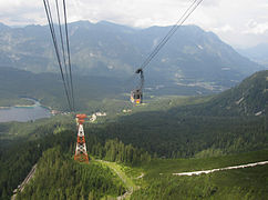
Cable car ride from the Zugspitze towards Eibsee

Frillensee with the Zugspitze in the background

View of the Eibsee with the Zugspitze in the background

View over the Eibsee
4K video Eibsee with Zugspitze

View from the Eibsee to the Ammergau Alps

Eibsee from the ripple crack
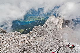
Eibsee from the Höllental via ferrata (Zugspitze)

.jpg)


See also
Web links
Individual evidence
- ↑ a b c d e f g Documentation of the condition and development of the most important lakes in Germany: Part 11 Bavaria (PDF; 1.7 MB)
- ↑ a b Presentation of the landslide on the Eibsee , website of the environmental geologist Hubert Engelbrecht, accessed on November 25, 2013
- ↑ [1]
- ↑ Collected writings of Baron Hermann von Barth, Ed. Carl Bünsch, Max Rohrer, Alpine Verlagsanstalt, Munich, 1926, p. 869
- ^ Website of the Eibsee Hotel , accessed on November 25, 2013