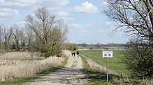
Elsflether Sand

The Elsflether Sand is a former Weser island in front of the Hune estuary. Due to flood protection buildings, it has been a peninsula between the Hunte and the Weser since 1979 and forms the left bank of the Weser from river kilometers 28 to 32 of the Unterweser . Elsflether Sand has belonged to the JadeWeserPort operating company since January 1, 2019 , which wants to set up a compensation area on the peninsula.
geography
Elsflether Sand is four kilometers long and at its widest point is less than a kilometer. It is a peninsula through its integration into the Weser dike, which runs through the northern two thirds in the longitudinal direction and ends half a kilometer from the northern tip at the Huntes barrage . In the east the island is bounded by the Weser, in the south by the Weser arm Rekumer Loch , in the south-west by the Westergate and in the west by the mouth of the Huntem. To the north of the dike connection, it belongs politically to the city of Elsfleth , to the south to the municipality of Berne , the southern third of the Weser beach in Bremen .
use
Around half of the land area is enclosed by summer dykes and used for agriculture, the other half is partly overgrown with bushes and partly with rough grass, partly with a sandy beach. From the northern tip of Stedingen , a road leads along the back of the dike to the Huntes barrier, on which the Hunte can be crossed for a short time every hour on the hour. It is closed to general motor traffic and part of the Weserradweg and Deutsche Sielroute cycle paths . Several beacons along the east side of the peninsula serve to ensure the safety of shipping on the Lower Weser.
Compensation area for the JadeWeserPort
On January 1, 2019, Jade-Weser-Port-Marketing GmbH & Co. KG bought the area. It is planned to build a compensation area on Elsflether Sand in order to compensate for the development of part of the Voslapper Groden nature reserve as part of the expansion of the JadeWeserPort . This is intended to improve the breeding conditions of the bittern , potted moorhen , bluethroat , water rail , reed warbler and reed warbler. The agricultural management, which currently still uses the Elsflether Sand, is to cease operations until the completion of the compensation area in 2023. The access to the sandy beaches and the bike path will be retained despite the rededication.
history
When, after the storm surge of 1962 , work began to secure the mouths of larger tributaries of the Lower Weser with barriers, the Huntes barrage was also to be built a little upstream from the Huntes estuary. The city of Elsfleth with its city center located directly on the low bank of the Weser was faced with the problem that any improvement in flood protection on the bank would have involved painful cuts in the cityscape. Therefore, at their insistence, the northern part of the Westergate arm of the Weser in front of the city was included in the protected area of the Hunte.
Web links
- Weser peninsula Elsflether Sand , Radio Bremen
- Federal state study climate change and coast: Case study Weser estuary (PDF; 5.3 MB) with several maps of the dike foreland of the Lower Weser, u. a .: Page 15, Lower Weser and its tributaries with rough classification of the areas in the dyke foreland; Page 35, Biotopes in the foreland of the dike with a differentiated representation of the land use
- Aerial photos of the north end and the south end of the peninsula
supporting documents
- ↑ Gunars Reichenbachs: Lower Saxony's strangest border runs in the Wesermarsch. Nordwest-Zeitung , October 16, 2017, accessed on April 2, 2018 .
- ^ Weser peninsula "Elsflether Sand" , City of Elsfleth.
- ↑ Study on tourism on the Unterweser (PDF; 5.3 MB): p. 24 nature observation station on the Deutsche Sielroute cycle path
- ↑ Beacon on the Elsflether Sand
- ↑ Peninsula Elsflether Sand is to become a bird paradise in NWZ-online on January 8, 2019, accessed on February 11, 2019
- ↑ Nordseezeitung 2009 on the Huntesperrwerk ( page no longer available , search in web archives ) Info: The link was automatically marked as defective. Please check the link according to the instructions and then remove this notice.
Coordinates: 53 ° 13 ′ 53.3 " N , 8 ° 28 ′ 33.4" E

