Europastraße 50
Coordinates: 49 ° 15 '58.2 " N , 7 ° 7' 22.8" E
| Europastraße 50 | ||||||||||||||||||||||||||||||||||||||||||||||||||||||||||||||||||||||||||||||||||||||||||||||||||||||||||||||||||||||||||||||||||||||||||||||||||||||||||||||||||||||||||||||||||||||||||||||||||||||||||||||||||||||||||||||||||||||||||||||||||||||||||||||||||||||||||||||||||||||||||||||

|
||||||||||||||||||||||||||||||||||||||||||||||||||||||||||||||||||||||||||||||||||||||||||||||||||||||||||||||||||||||||||||||||||||||||||||||||||||||||||||||||||||||||||||||||||||||||||||||||||||||||||||||||||||||||||||||||||||||||||||||||||||||||||||||||||||||||||||||||||||||||||||||
| map | ||||||||||||||||||||||||||||||||||||||||||||||||||||||||||||||||||||||||||||||||||||||||||||||||||||||||||||||||||||||||||||||||||||||||||||||||||||||||||||||||||||||||||||||||||||||||||||||||||||||||||||||||||||||||||||||||||||||||||||||||||||||||||||||||||||||||||||||||||||||||||||||
| Basic data | ||||||||||||||||||||||||||||||||||||||||||||||||||||||||||||||||||||||||||||||||||||||||||||||||||||||||||||||||||||||||||||||||||||||||||||||||||||||||||||||||||||||||||||||||||||||||||||||||||||||||||||||||||||||||||||||||||||||||||||||||||||||||||||||||||||||||||||||||||||||||||||||
| Overall length: | 4910 km | |||||||||||||||||||||||||||||||||||||||||||||||||||||||||||||||||||||||||||||||||||||||||||||||||||||||||||||||||||||||||||||||||||||||||||||||||||||||||||||||||||||||||||||||||||||||||||||||||||||||||||||||||||||||||||||||||||||||||||||||||||||||||||||||||||||||||||||||||||||||||||||
|
States : |
||||||||||||||||||||||||||||||||||||||||||||||||||||||||||||||||||||||||||||||||||||||||||||||||||||||||||||||||||||||||||||||||||||||||||||||||||||||||||||||||||||||||||||||||||||||||||||||||||||||||||||||||||||||||||||||||||||||||||||||||||||||||||||||||||||||||||||||||||||||||||||||
| The E 50 on the German Autobahn 6 near Heuchelheim , direction Mannheim | ||||||||||||||||||||||||||||||||||||||||||||||||||||||||||||||||||||||||||||||||||||||||||||||||||||||||||||||||||||||||||||||||||||||||||||||||||||||||||||||||||||||||||||||||||||||||||||||||||||||||||||||||||||||||||||||||||||||||||||||||||||||||||||||||||||||||||||||||||||||||||||||
|
Course of the road
|
||||||||||||||||||||||||||||||||||||||||||||||||||||||||||||||||||||||||||||||||||||||||||||||||||||||||||||||||||||||||||||||||||||||||||||||||||||||||||||||||||||||||||||||||||||||||||||||||||||||||||||||||||||||||||||||||||||||||||||||||||||||||||||||||||||||||||||||||||||||||||||||
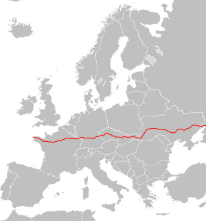
The European route 50 (short: E 50 ) is a 5000 km long European route from the Atlantic Ocean in the west to the Caspian Sea in the east . It leads from Brest in France through Germany , the Czech Republic , Slovakia and the Ukraine to Makhachkala in the Russian republic of Dagestan .
National roads

The E 50 on the Ukrainian M 04 trunk road near Schowte
France
Germany
Czech Republic
Slovakia
- Hauptstrasse 9
- Motorway D1 (four times in total)
- Motorway D3
- Hauptstrasse 61
- Hauptstrasse 18
- Hauptstrasse 68
- Hauptstrasse 20
- Expressway feeder 3
- Hauptstrasse 19
Ukraine
Russian Federation
- M 19
- M 4
- M 20
Places on the E 50
- Brest - Morlaix - Saint-Brieuc - Rennes - Laval - Le Mans - Chartres - Paris - Reims - Châlons-en-Champagne - Verdun - Metz - Saarbrücken - Kaiserslautern - Ludwigshafen am Rhein - Mannheim - Heilbronn - Schwäbisch Hall - Ansbach - Schwabach - Nuremberg - Amberg - Vohenstrauß - Waidhaus - Pilsen - Prague - Humpolec - Jihlava - Brno - Trenčín - Žilina - Ružomberok - Poprad - Prešov - Košice - Uzhhorod - Mukachevo - Stryi - Ternopil - Vinnytsia - Nemyriw - Uman - Kropywnyzkyj - Pjatychatky - Dnipro - Donetsk - Debaltseve - Rostov-on-Don - Armavir - Makhachkala
See also
Web links
Commons : E50 - collection of pictures, videos and audio files


