Fokida
|
Fokida Regional Unit Περιφερειακή Ενότητα Φωκίδας (Φωκίδα) |
|
|---|---|
| Basic data | |
| State : | Greece |
| Region : | Central Greece |
| Area : | 2,210 km² |
| Residents : | 40,343 (2011) |
| Population density : | 18.3 inhabitants / km² |
| NUTS 3 code no. : | GR645 |
| Structure: | 2 municipalities |
| Website: | www.fokida.gr |
The central Greek landscape of Fokida ( modern Greek Φωκίδα , German also Fokis or Phokis ) forms one of the five regional districts of the Greek region of Central Greece . The capital is the city of Amfissa , which is also the largest city in the administrative district. The area of Fokidas has belonged to the state territory since modern Greece was founded in 1828, but only became an independent prefecture from 1899–1909 and permanently from 1943. It was divided into the two provinces (Ez. Gr. Eparchia ) Dorida ( Doris ) and Parnassida (Parnassis). In 1997, the towns and villages of Fokidas were combined into twelve parishes. With the Greek administrative reform , the powers of the prefecture were transferred to the region of Central Greece and the merged municipalities of Dorida and Delfi , which roughly correspond to the areas of the two provinces that were abolished in 1997. Since then, the Fokida regional district has sent four members of the Central Greek Regional Council, but has no political significance beyond that.
geography
The Fokida landscape is located in the middle of the southern mainland of Greece and forms a coastline in the south with the eastern part of the Gulf of Corinth, east of the Strait of Rio-Andirrio and west of the Isthmus of Corinth. In the west Fokida borders on Aetolia-Acarnania , in the north on Fthiotida and in the east on Boeotia.
The landscape of Fokida is dominated by the high mountain ranges of the Giona (one of the five Greek mountains with an altitude of more than 2500 m above sea level) and the Parnassus (Parnassos; altitude 2455 m above sea level). The Parnassos massif divides Fokida into two parts. The south and east of the district are without forest cover and predominantly stony and rocky in character. The valley, which stretches from the Gulf of Corinth and the small town of Itea north to Amfissa, is used for agriculture throughout. Green and forest areas can be found in Fokida's west, north and in the central part of the regional district.
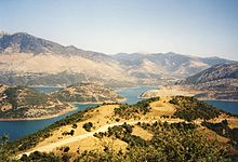
Located in the west of Fokida towards Aetolia-Akarnania and Nafpaktos inland, the Mornos reservoir is a dominant mark of the landscape. The Mornos dam dams the river Mornos , which flows into the Gulf of Corinth , into a 1 to 3 km² reservoir. The reservoir was completed in the 1960s.
history
For the history of the area in antiquity, see Phocis .
Like the rest of Greece, Phocis (Fokida) fell under the rule of the Ottoman Empire between 1400 and 1453 AD and remained under Ottoman control until the outbreak of the Greek struggle for independence in 1821. Several people from Fokida took part in the Greek War of Independence against the Ottoman occupation from 1821 to 1829: Salonon Isaiah, Athanasios Diakos , Androutsos, Panougias, Diobouniotis, Trakas, Gouras, Mitropoulos. On April 10, 1821, Amfissa Castle was conquered, which is still celebrated today with a folk festival.
During the Second World War, under Italian and German occupation (1941-1944), the region of Fokida was the scene of several punitive actions by the occupying powers in the form of burnings of villages such as Agia Efthimia, Vounichora and Segditsa, as well as executions. These punitive actions were based on the strong partisan activity, which was favored by the mountainous landscape. Fokida was also the scene of the Greek Civil War from 1946 to 1949.
economy
The economy of Fokida is based in part on agriculture . The olive growing and beekeeping are two important agricultural areas. Furthermore, fish farms and livestock are operated. Fokida has bauxite deposits, which are mined.
traffic
Fokida is crossed by two national roads in Greece.
- The national road 48 leads from Andirrio in Aetolia-Acarnania in the west via Nafpaktos to Fokida. It runs essentially along the coastline of the area and thus connects the main towns of Fokida such as Galaxidi, Itea and Amfissa. At Itea the national road 48 changes its course from west to east and swings to the north. After passing through Amfissa, it continues to Boeotian Livadia . There it ends at Nationalstrasse 3 ( Europastrasse 65 ). The national road 48 was re- routed in parts between Eratini and Chrisso.
- The national road 27 leads from Amfissa north to Lamia and crosses the highway 1 ( European route 75 ) from Thessaloniki to Athens after the intermediate point Bralos .
The area does not have a connection to the Greek railway network, nor is there an airport in the Fokida area. Seaports of little economic importance are Itea and Galaxidi.
Attractions
Sights of Fokidas are
- Delphi
- Amfissa Archaeological Museum
- Byzantine Church of St. Sotiros in Amfissa
- Naval Museum in Galaxidi
- Ancient walls of Lilaia near today's Lilea
- Parnasso mountains with ski center
- Giona Mountains
- Oiti Mountains
- Vardousia Mountains
- Itea port
- Mornos Reservoir
- Folklore Museum in Agoriani
- Monastery of the Prophet Elias (Profitis Ilias)
- Amfissa Castle
Personalities
- Giannis Skarimpas (born September 28, 1893 in Agia Efthymia, † January 21, 1984) - writer
- Eleni Karaindrou (born November 25, 1939 in Tichio Doridas) - composer
Web links
- District web presence (in Greek and English).
- Aerial photos of Fokida ( Memento of August 18, 2007 in the Internet Archive ) (description in Greek).
- Information about Fokida ( Memento of May 29, 2007 in the Internet Archive ) (in English).
Individual evidence
- ↑ Results of the 2011 census at the National Statistical Service of Greece (ΕΛ.ΣΤΑΤ) ( Memento from June 27, 2015 in the Internet Archive ) (Excel document, 2.6 MB)


