Frauenrain
|
Frauenrain
Antdorf municipality
Coordinates: 47 ° 44 ′ 26 " N , 11 ° 18 ′ 34" E
|
|
|---|---|
| Height : | 655 m |
| Residents : | 33 (1987) |
| Incorporation : | May 1, 1978 |
| Postal code : | 82387 |
| Area code : | 08856 |
|
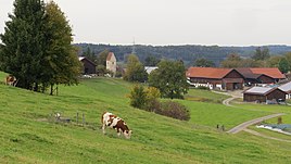
Frauenrain from the southeast
|
|
Frauenrain is a former municipality in Upper Bavaria and is now part of the municipality of Antdorf in the Weilheim-Schongau district .
geography
The hamlet is hidden in the hollow of a moraine ridge , about one kilometer south of Antdorf. Today it consists of five courtyards and the Church of the Assumption of Mary .
history
With the community edict of 1818 , the community of Frauenrain was created, which belonged to the Weilheim district court and was approximately 1319 hectares in size. Before the regional reform in Bavaria, this included the following districts:
|
|
On January 1, 1978, the community of Frauenrain was dissolved as part of the regional reform. Most of the area with 170 inhabitants was incorporated into Antdorf. The district Steinbach with about 15 inhabitants came to Iffeldorf .
politics
The following people were the mayor or mayor of the Frauenrain community from 1833 until the community was dissolved in 1978:
| Period | Surname |
|---|---|
| 1833-1835 | Johann Stückl |
| 1836-1842 | Andreas Weingand |
| 1843-1944 | Ignaz Walser |
| 1845-1850 | Leonhard Jochner |
| 1851-1853 | Anton Daisenberger |
| 1854-1856 | N. Risslberger |
| 1857-1860 | Johann Spensberger |
| 1861-1869 | Johann Finsterwalder |
| 1870-1875 | Ignaz Probst |
| 1876-1881 | Philipp Adlwart |
| January - July 1882 | Andreas Zwerger |
| July 1882–1899 | Ulrich Adlwart |
| 1900-1905 | Josef Heiss |
| 1906 - June 1945 | Anton Annaberger |
| June - September 1945 provisional |
Johann Bach |
| September 1945 - March 1962 to January 1946 provisional, then regular |
Josef Bauer |
| May 1962–1978 | Georg Sonner |
Attractions
Soil monuments
See: List of ground monuments in Antdorf
literature
- Georg Paula , Stefanie Berg-Hobohm : District Weilheim-Schongau (= Bavarian State Office for Monument Preservation [Hrsg.]: Monuments in Bavaria . Volume I.23 ). Lipp, Munich 2003, ISBN 3-87490-585-3 , pp. 20-22 .
- Jakob Sonner: Local history of the rural community Frauenrain . 2nd supplemented edition, Frauenrain 1978
Web links
- Frauenrain in the location database of the Bayerische Landesbibliothek Online . Bavarian State Library
- Antdorf municipality
Individual evidence
- ↑ Bavarian State Statistical Office (ed.): Official city directory for Bavaria, territorial status on October 1, 1964 with statistical information from the 1961 census . Issue 260 of the articles on Bavaria's statistics. Munich 1964, DNB 453660959 , Section II, Sp. 255 ( digitized version ).
- ↑ K. Bayer. Statistical Bureau (Ed.): Directory of localities of the Kingdom of Bavaria, with alphabetical register of places . LXV. Issue of the contributions to the statistics of the Kingdom of Bavaria. Munich 1904, Section II, Sp. 354 ( digitized version ).
- ↑ Kgl. Statistical Bureau (ed.): Complete list of localities of the Kingdom of Bavaria. According to districts, administrative districts, court districts and municipalities, including parish, school and post office affiliation ... with an alphabetical general register containing the population according to the results of the census of December 1, 1875 . Adolf Ackermann, Munich 1877, 2nd section (population figures from 1871, cattle figures from 1873), Sp. 373 , urn : nbn: de: bvb: 12-bsb00052489-4 ( digital copy ).
- ^ Federal Statistical Office (ed.): Historical municipality directory for the Federal Republic of Germany. Name, border and key number changes in municipalities, counties and administrative districts from May 27, 1970 to December 31, 1982 . W. Kohlhammer, Stuttgart / Mainz 1983, ISBN 3-17-003263-1 , p. 595 .
- ↑ Max Biller: Antdorfer native lexicon . Ed .: Municipality of Antdorf. Weilheim 2000, OCLC 163415926 , p. 110 ff.


