Weilheim-Schongau district
| coat of arms | Germany map |
|---|---|

|

Coordinates: 47 ° 47 ' N , 11 ° 3' E |
| Basic data | |
| State : | Bavaria |
| Administrative region : | Upper Bavaria |
| Administrative headquarters : | Weilheim i.OB |
| Area : | 966.37 km 2 |
| Residents: | 135,478 (Dec. 31, 2019) |
| Population density : | 140 inhabitants per km 2 |
| License plate : | WM, SOG |
| Circle key : | 09 1 90 |
| NUTS : | DE21N |
| Circle structure: | 34 municipalities |
| Address of the district administration: |
Pütrichstrasse 8 82362 Weilheim i.OB |
| Website : | |
| District Administrator : | Andrea Jochner-Weiß ( CSU ) |
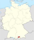
| Location of the district of Weilheim-Schongau in Bavaria | |
The district of Weilheim-Schongau is located in the southwest of the Bavarian administrative district of Upper Bavaria . The district was created in its current form in 1972 from the amalgamation of the Weilheim districts in Upper Bavaria and Schongau .
geography
location
In the west the Lech , in the core area the Ammer (and the Ammersee ) and on the eastern border of the district the Loisach are the most important waters. Lake Starnberg borders in the northeast . The Hohe Peißenberg at 988 m divides the Schongau area from the Weilheim area . The highest point in the district is the Niederbleick near Wildsteig at 1589 m, the lowest point is the mouth of the Ammer near Fischen am Ammersee at 533 m.
In contrast to the lower Lech north of Augsburg, the border between the Bavarian and Swabian language areas forms a broad transition between Lech and Ammer here in the upper Lechgau and in Lechrain .
Neighboring areas
The district borders in a clockwise direction in the north, beginning with the districts of Landsberg am Lech , Starnberg , Bad Tölz-Wolfratshausen , Garmisch-Partenkirchen and Ostallgäu .
geology
The geomorphological appearance of the district is particularly shaped by the ice ages of the Quaternary , which began about 2.6 million years ago. During glaciations, glacier paved repeated from the Central Alps (such as the Oetztal) their way through the northern parts of the Alps until well into the foothills of the Alps in and scraped Among other things, the lakes of the district from the previously formed during the Tertiary Molasseuntergrund out. In particular, the main tongue of the Isar-Loisach glacier , which erupted between Herzogstand and Jochberg , pushed masses of earth and rock almost as far as Munich. The advance and melting of the glacier in the Würm glacial period is of particular importance for the shape of the natural area, as the moraine walls and tumuli deposited in the process form the basis of the many hills (chains) in the district.
For more detailed information on the geology of the region, please refer to the article on the Alpine Foreland .
history
Early history
For a long time, today's district was covered with a dense jungle and uninhabited by people. The earliest finds of human activity date from the later Stone Age . From the Pollingen culture (3900 to 3500 BC) finds of handle cups or pots with carpet-like decorations come. Further traces of settlement come from the Bronze Age . Before the Romans , who from 15 BC BC came into the area, the Celts were in the district area. The Roman province to which the area belonged was called Raetien . Around 476, the Romans retreated south. Then the Bavarians came to the eastern part of the district and the Alemanni to the west, and to this day there is a language border between the Bavarian dialect and the Lechrain dialect or the East Swabian dialect west of the Lech. In the course of time Franks , Welfen , the Hohenstaufen , Huosi , Andechs-Meranier , Agilolfinger and the Wittelsbacher ruled the area.
Regional courts
In 1803 the district courts of Weilheim and Schongau were established in today's district area . They belonged to the Isar district , which was renamed Upper Bavaria in 1838.
District Offices
In 1862 the district offices of the same name were formed from the Weilheim district courts in Upper Bavaria and Schongau .
Counties
On January 1, 1939, the designation district was introduced as everywhere else in the German Reich . The district offices became the districts of Schongau and Weilheim in Upper Bavaria.
Weilheim-Schongau district
As part of the regional reform in Bavaria , a new district was formed on July 1, 1972 from the largest part of the Weilheim district in Oberbayern , the largest part of the Schongau district (both administrative districts of Upper Bavaria ) and the municipality of Ingenried of the Marktoberdorf district (administrative districts of Swabia ) initially the name "District Weilheim in Upper Bavaria" received. Some communities in the north of the Schongau district came to the Landsberg am Lech district , the Bayersoien community and several communities in the south of the Weilheim district were assigned to the Garmisch-Partenkirchen and Bad Tölz-Wolfratshausen districts . On May 1, 1973, the new district was given the double name "Weilheim-Schongau district".
Population development
The district of Weilheim-Schongau gained around 23,000 inhabitants between 1988 and 2008 or grew by around 21%. Between 1988 and 2018 the district grew from 107,913 to 135,348 by 27,435 inhabitants or by 25.4%.
The following figures refer to the territorial status on May 25, 1987.
| year | 1840 | 1871 | 1900 | 1925 | 1939 | 1950 | 1961 | 1970 | 1987 | 1991 | 1995 | 2000 | 2005 | 2010 | 2015 |
| population | 25,872 | 29,897 | 40,827 | 53.209 | 57,682 | 89,577 | 88.024 | 96,358 | 106,374 | 114,562 | 120,756 | 127.018 | 131.034 | 130.922 | 132.906 |
Architectural monuments
See monuments in the Weilheim-Schongau district
Economy and Infrastructure
The district is one of the ten German districts with the lowest unemployment. It owes this to its grown and balanced economic structure of industry and handicrafts, agriculture, trade and services, which lacks the monotony caused by large companies. Craft and medium-sized companies shape the economic structure, almost two thirds of the employees in the district are employed here. The vocational training and technology center of the Chamber of Crafts for Munich and Upper Bavaria (BTZ) for five Upper Bavarian districts is located in Weilheim.
The income taxpower per inhabitant was 291 euros in 2004 (national average 216). The purchasing power per inhabitant in 2005 was 9,457 euros (national average 8,523).
In the 2016 Future Atlas , the Weilheim-Schongau district was ranked 107th out of 402 districts, municipal associations and independent cities in Germany, making it one of the regions with “future opportunities”. In the 2019 edition, it improved to 401 out of 401.
traffic
Streets
Traffic through the district is relatively calm: the motorway network only touches the district in the east ( A 95 Munich – Garmisch). The main traffic arteries are the B 2 , B 23 , B 472 and B 17 .
train
The district town of Weilheim with the Weilheim (Oberbay) train station is a hub of the regional rail network. The city itself took the initiative to build the railway in the 19th century and opened the following routes at its own expense:
- 1865: Tutzing – Penzberg
- 1866: Tutzing – Weilheim –Unterpeißenberg
The Royal Bavarian State Railways expanded the rail network with the connections Unterpeißenberg - Peißenberg (1875) and Weilheim - Murnau (1879). In 1898 it was continued from Penzberg via Bichl to Kochel and the Augsburg – Weilheim connection along the Ammersee.
The city of Schongau was initially connected to Landsberg parallel to the Lech in 1886 . It took over 30 years until the gap from Schongau via Peiting to Peißenberg was closed in 1917 and trains could also run to Weilheim. Finally - already under the direction of the Deutsche Reichsbahn - the branch line Schongau – Kaufbeuren followed in 1923 . This was shut down in 1972, and in 1984 passenger traffic on the Schongau – Landsberg route , on which DB Cargo now operates freight trains. For passenger traffic, around 75% of the original network of around 100 km in length is still in operation.
politics
District administrators
| Term of office | District Administrator | Political party |
|---|---|---|
| July 1, 1972 to April 30, 1978 | Georg Bauer | CSU |
| May 1, 1978 to April 30, 1996 | Manfred Blaschke | CSU |
| May 1, 1996 to April 30, 2008 | Luitpold brown | CSU |
| May 1, 2008 to April 30, 2014 | Friedrich Zeller | SPD |
| since May 1, 2014 | Andrea Jochner-Weiss | CSU |
In a runoff election on March 30, 2014, Andrea Jochner-Weiß prevailed against Friedrich Zeller with 68.02 percent of the vote.
District council
| Party / list | 2020 election | Election 2014 | 2008 election | Election 2002 | ||||
|---|---|---|---|---|---|---|---|---|
| % | Seats | % | Seats | % | Seats | % | Seats | |
| CSU | 34.0 | 20th | 38.7 | 23 | 40.9 | 25th | 53.5 | 33 |
| GREEN | 17.4 | 10 | 10.9 | 7th | 9.6 | 6th | 7.8 | 4th |
| SPD | 11.0 | 7th | 19.2 | 12 | 22.0 | 13 | 24.6 | 15th |
| BfL (citizens for the Weilheim-Schongau district) | 10.0 | 6th | 13.7 | 8th | 15.5 | 9 | - | - |
| ödp | 6.5 | 4th | - | - | - | - | - | - |
| Free voters | 6.4 | 4th | 5.8 | 3 | - | - | - | - |
| AfD | 5.0 | 3 | - | - | - | - | - | - |
| Independent | 2.7 | 2 | - | - | - | - | - | - |
| BfP (citizens for Penzberg) | 2.3 | 1 | - | - | - | - | - | - |
| FDP | 2.0 | 1 | 1.8 | 1 | 3.5 | 2 | 2.5 | 1 |
| Bavaria Party | 1.6 | 1 | 2.9 | 2 | - | - | - | - |
| The left | 1.1 | 1 | - | - | - | - | - | - |
| Independent / oedp | - | - | 6.7 | 4th | 6.5 | 4th | - | - |
| REP | - | - | 0.3 | 0 | 2.0 | 1 | 1.7 | 1 |
| Party free u. Independent Community of voters | - | - | - | - | - | - | 10.1 | 6th |
| total | 100 | 60 | 100 | 60 | 100 | 60 | 100 | 60 |
| voter turnout | 65.5% | 62.1% | 67.1% | 67.2% | ||||
badges and flags
The district of Weilheim-Schongau was given the approval of the district council and the approval of the government of Upper Bavaria by letter of May 21, 1974, to use the coat of arms described below.
| Blazon : "Under a golden shield head, inside a striding, looking, red armored and red-tongued black lion, in blue a golden abbot's staff, on which a silver mallet and a silver hammer is crossed at an angle." | |
| Justification of the coat of arms: The lion is taken from the coat of arms of the Hohenstaufen , who as heirs of the Welfs were wealthy in the upper Lechrain region since the end of the 12th century and played an important historical role as Swabian dukes , German kings and emperors . The looking lion is at the same time the coat of arms of the Guelph dukes, as it has been handed down in Steingaden. Welfish patrimonial estates were in the Schongau area. The abbot's staff underlines the great cultural and economic importance of the former monasteries Wessobrunn , Polling , Habach , Bernried , Rottenbuch and Steingaden in the district area . The miner's tools, hammer and mallet , are the heraldic symbols for mining and are reminiscent of the state pitch coal mining in Penzberg and Peißenberg, which had been more intensively pursued since the 19th century and which flourished in the 1960s and continued until the mines were closed 1966/71 shaped the economic life of the district. The tinging of the main field in silver and blue indicates the Wittelsbach rulership since 1268 and belonging to Bavaria . The district coat of arms, which has been in effect since 1974, symbolizes the composition of the administrative district from the former districts of Schongau and Weilheim . By adopting the Staufer lion from the earlier Schongau district coat of arms and the figure with hammer, mallet and abbot's staff from the earlier Weilheim coat of arms, the emblem does justice to both sub-areas of the Weilheim-Schongau district, which was formed in 1972 and where the district office is located in Weilheim. |
flag
- "The district carries a flag in the colors black-yellow-blue."
- Like the coat of arms, the district has been using this flag since May 21, 1974.
Communities
(Residents on December 31, 2019)
|
Other communities
|
Protected areas
In the district there are 23 nature reserves , 17 landscape protection areas , 22 FFH areas and at least 67 geotopes designated by the Bavarian State Office for the Environment (as of August 2016)
See also
- List of nature reserves in the Weilheim-Schongau district
- List of landscape protection areas in the Weilheim-Schongau district
- List of FFH areas in the Weilheim-Schongau district
- List of geotopes in the Weilheim-Schongau district
- List of natural monuments in the Weilheim-Schongau district
License Plate
On August 5, 1974, the district was assigned the WM distinctive mark, which had been valid since July 1, 1956 for the Weilheim district in Upper Bavaria . It is still issued today.
Until the 1990s, vehicles from the old district of Schongau received license plates with the letter pairs AA to ZZ and the numbers from 100 to 999.
Since September 16, 2013, the distinctive sign SOG awarded in the former district of Schongau has been available again.
See also
- List of places in the district of Weilheim-Schongau
- Lists of the architectural monuments in the Weilheim-Schongau district
Web links
- Official website of the district
- Literature from and about the district of Weilheim-Schongau in the catalog of the German National Library
- Entry on the coat of arms of the Weilheim-Schongau district in the database of the House of Bavarian History
Individual evidence
- ↑ "Data 2" sheet, Statistical Report A1200C 202041 Population of the municipalities, districts and administrative districts 1st quarter 2020 (population based on the 2011 census) ( help ).
- ↑ Meyer, Rolf KF, Schmidt-Kaler, Hermann .: Walks in the history of the earth. (8), On the trail of the Ice Age south of Munich: eastern part . Pfeil, Munich 1997, ISBN 3-931516-09-1 .
- ↑ Walter Irlinger: The pre-Roman periods and the early Middle Ages. In: Georg Paula , Stefanie Berg-Hobohm : District of Weilheim-Schongau: Monuments in Bavaria. Volume 1, Lipp, Munich 2003
- ^ Max Biller: Pollinger Heimat-Lexikon. Polling 1992, half volume 2, p. 1049.
- ^ History. In: The district of Weilheim-Schongau. Editor: District Office Weilheim-Schongau 2010, Texts: Max Biller (district archivist), Helmut Schmidbauer (district home administrator), p. 8 f.
- ^ Wilhelm Volkert (ed.): Handbook of Bavarian offices, communities and courts 1799–1980 . CH Beck, Munich 1983, ISBN 3-406-09669-7 , p. 97 .
- ^ Ordinance on the reorganization of Bavaria into rural districts and independent cities of December 27, 1971
- ↑ Statistics for the district (PDF) accessed on October 23, 2010.
- ↑ Future Atlas 2016. (No longer available online.) Archived from the original on October 2, 2017 ; accessed on March 23, 2018 . Info: The archive link was inserted automatically and has not yet been checked. Please check the original and archive link according to the instructions and then remove this notice.
- ↑ PROGNOS future atlas. Handelsblatt, accessed on December 10, 2019 .
- ^ Ludwig Degele: The railway in the district of Weilheim-Schongau. Self-published, Weilheim 1981, p. 32.
- ↑ Peter Rasch: The branch lines between Ammersee, Lech and Wertach. With the Ammerseebahn, Pfaffenwinkelbahn & Co around the Bavarian Rigi. EOS Verlag, St. Ottilien 2011, ISBN 978-3-8306-7455-9 , p. 158 f.
- ↑ Weilheimer Tagblatt from Monday, March 31, 2014, local section p. 1.
- ↑ Results of the 2020 local elections , accessed on March 17, 2020
- ^ Result of the 2014 local elections , accessed on March 18, 2014
- ↑ Weilheimer Tagblatt of March 18, 2014, local section p. 4.
- ↑ District election 2008 ( Memento of August 8, 2011 in the Internet Archive ), accessed on October 22, 2010.
- ↑ a b Entry on the coat of arms of the Weilheim-Schongau district in the database of the House of Bavarian History , accessed on September 5, 2017 .
- ↑ Flags of the world: Weilheim-Schongau district ( Memento from July 2, 2013 in the Internet Archive )
- ↑ "Data 2" sheet, Statistical Report A1200C 202041 Population of the municipalities, districts and administrative districts 1st quarter 2020 (population based on the 2011 census) ( help ).


