
Frojach (municipality of Teufenbach-Katsch)
|
Frojach City cadastral municipality Frojach
|
|||
|---|---|---|---|
|
|||
| Basic data | |||
| Pole. District , state | Murau (MU), Styria | ||
| Judicial district | Murau | ||
| Pole. local community | Teufenbach-Katsch | ||
| Coordinates | 47 ° 7 '58 " N , 14 ° 18' 29" E | ||
| Residents of the village | 574 (January 1, 2020) | ||
| Area d. KG | 24.48 km² | ||
| Post Code | 8841 Frojach | ||
| Statistical identification | |||
| Locality code | 15987 | ||
| Cadastral parish number | 65207 | ||
| Counting district / district | Frojach (61446 001) | ||
| Former parish 1850–1967; 1968-2014 municipal seat of Frojach-Katsch (formerly ZSp 61403 000th.) Source: STAT : Gazetteer ; BEV : GEONAM ; GIS-Stmk |
|||

Frojach is a place in the upper Murtal in Styria as well as a place and cadastral municipality of the municipality of Teufenbach-Katsch in the Murau district .
geography
| Frojach (village) | |
|---|---|
| Basic data | |
| Pole. District , state | Murau , Styria |
| Pole. local community | Teufenbach-Katsch ( KG Frojach) |
| Locality | Frojach |
| Coordinates | 47 ° 7 ′ 57 ″ N , 14 ° 18 ′ 31 ″ E |
| height | 762 m above sea level A. |
| Building status | 60 (approx. Addresses 2018 ) |
| Statistical identification | |
| Counting district / district | Frojach (61446 001) |
| Frojach- Oberdorf Source: STAT : Directory of places ; BEV : GEONAM ; GIS-Stmk |
|
The place is located 11 kilometers east of the Mur downhill from Murau , and 4 km west of the valley from the municipal capital Teufenbach . To the south rises the Blasenkogel ( 1602 m above sea level ) of the Gurktal Alps , north of the Pleschaitz ( 1797 m above sea level ) the Wölzer Tauern and Murberge (parts of the Niedere Tauern ).
The village of Frojach is on the right bank a little off the banks of the Mur , at around 760 m above sea level. A. Height. It is a small street village with around 60 houses along the B96 Murtal Straße and on the Murtalbahn Unzmarkt – Mauterndorf. The small village of Angsdorf to the east has largely grown into the village. This place is also called the Oberdorf Kirchweiler, the Frojacher Unterdorf ∗ lies a little to the east.
The village and cadastral community of Frojach has an area of 2448 hectares and around 550 inhabitants (January 1, 2020: 574). Out of the valley, in addition to Angsdorf and Unterdorf, the local area includes the houses Puxerboden , then Graslitz and Lacken , and beyond the Mur Pux with Pux Castle , where the cadastral area still extends up the slopes of the Puxberg ( 1486 m above sea level ), and also the Pleschaitz - Summit touches. Haselbach and the village of Saurau follow in the valley , the cadastral border is just before the Triebendorf train station. The scattered houses Grasberg are located south of the Blasenkogel .
| Katsch an der Mur (O, KG Katsch) |
Raiming (O and KG, Gem. Oberwölz ) |
Niederwölz
(O, KG, and Gem.) |
|
Triebendorf (O and KG, municipality of Murau )
|
.svg)
|
Teufenbach
(O and KG) |
|
Grasberg St. blisters (O and KG, Gem. St. Lambrecht ) |
- ∗There are two upper and two lower villages in the municipality , one at Frojach and one at Katsch
History, infrastructure and sights
The Roman Murtalstraße , an important local Roman road with a connection to the Neumarkter Sattel to Carinthia as well as the Sölkpass into the Ennstal ( Via Julia Augusta Virunum - Ovila ) and into the Lungau ( Virunum - Iuvavum ), ran on the right (northern) side of the valley. Parts of the rock walls are well preserved there.
From the 9th century, a Carolingian royal estate was located here in the Mur, Wölzer, Katsch and Rantental areas in what was then Carantanic Styria, which the Archdiocese of Salzburg bequeathed to the Diocese of Freising in 1007 . Castle [ Alt- ] Pux and the cave castles in Puxerloch were built in the middle of the 11th century. Frojach was first mentioned in a document as Froiach in the middle of the 12th century , the manuscript was written in the St. Lambrecht Abbey and is kept in the Graz University Library. It was a manorial estate that was located in the Ober- / Unterdorf area. There was - closer to the Mur - the first church that is named as a parish in a document issued in Leibnitz in 1215.
Today's parish church of St. Andreas is an originally Protestant church, built between 1527 and 1555, “in the shadow” further away from the Mur, around which today's village Frojach (Oberdorf) was formed as a hamlet . The old Catholic parish church was torn away by a flood in 1711, and the Protestant church, which had already been abandoned at the time of the Counter Reformation around 1600, was adapted. Today it is mainly neo-Gothic from the renovation in 1899. The rectory from the middle of the 17th century is also a listed building. The Maria Dorn branch church with churchyard in Sarau (1680) is also worth seeing.
With the creation of the local parishes after 1848/49 Frojach became an independent parish . The Murtalbahn is a narrow-gauge railway that was built in the 1890s. It is operated as a museum railway, the railway station Frojach-Katschtal is also a listed building.
As of 1 January 1968, the community was in the municipality structural reform Katsch to the municipality Frojach-Katsch merged , Frojach remained municipal seat . As of 1 January 2015, as part second municipality structural reform also Teufenbachstrasse to set, and the community Teufenbach-Katsch emerged, bringing the municipal office after Teufenbach migrated.
- In the village of Frojach
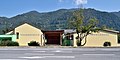
Frojach elementary school and multi-purpose hall


- In the village
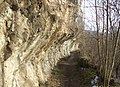
Römerweg near Pux

Maria Dorn in Sarau


Web links
literature
- Walter Brunner : Frojach-Katsch: Diversity and unity of the long history of a small living space. 2005.
proof
- 61446 - Teufenbach-Katsch. Community data, Statistics Austria .
- ↑ a b c d e Parish Church of St. Andreas. Website of the community → Church & Chapel & wayside shrine , accessed September 8, 2019.
- ^ Lit. Walter Brunner: Frojach-Katsch. 2005, p. 36 ff.
- ↑ Section 9 (1) of the law of December 18, 1967 on the change of territory of municipalities. LGBl. 139/1967 (eReader, ALEX Online ).
- ↑ Section 3, Paragraph 7, Item 1 of the Act of December 17, 2013 on the reorganization of the municipalities of the State of Styria (Styrian Municipal Reform Act - StGsrG). LGBl. No. 31/2014 (pdf, ris.bka ).

Cadastral parishes and localities: Frojach | Katsch an der Mur (KG Katsch ) | Teufenbach
Villages: Frojach • Saurau • Teufenbach | Hamlet: Angsdorf • Haselbach | Rotten: Graslitz • Lacken • Oberdorf • Priel • Pux • Puxerboden • Sonnseite • Unterdorf (Frojach) • Unterdorf (Katsch) | Scattered houses: Gal [l] berg • Göglburg • Grasberg • Giant | Other locations: Altteufenbach Castle • Katsch an der Mur • Katsch ruins • Kropfmoar • Pux Castle • Sankt Lorenzen
Counting district: Teufenbach | Frojach | Katsch on the Mur
Former parishes: Frojach 1850–1967 | Katsch 1850–1967 | Teufenbach 1850–2014 | Frojach-Katsch 1968-2014