Gampenpass
| Gampenpass / Passo delle Palade | |||
|---|---|---|---|
|
Pass summit, view to the south |
|||
| Compass direction | North | south | |
| Pass height | 1518 m slm | ||
| province | Bolzano (Region Trentino-South Tyrol ) | ||
| Watershed | Etsch | Noce → Etsch | |
| Valley locations | Lana ( Adige Valley ) | Fondo ( Val di Non ) | |
| expansion |
|
||
| Mountains | Nonsberg group | ||
| profile | |||
| Ø pitch | 6.9% (1202 m / 17.5 km) | 4.1% (530 m / 13 km) | |
| Max. Incline | 8.5% | 6% | |
| map | |||
|
|
|||
| Coordinates | 46 ° 31 '50 " N , 11 ° 6' 44" E | ||
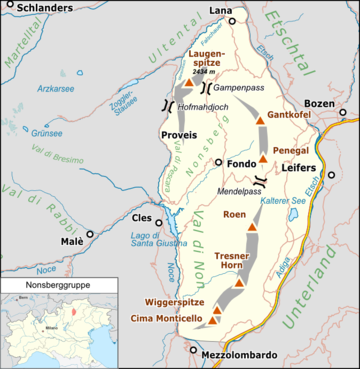
The Gampenpass , or Gampen for short (rarely also Gampenjoch , Italian Passo delle Palade ), is a 1518 m slm high mountain pass in the South Tyrolean part of the Nonsberg group . It connects the Adige Valley with the Non Valley via the Gampenpassstrasse .
location
Location of the Gampenpass in the Nonsberg group. |
history
The Gampenpass is the highest point of an old road connection that connected the Burgrave's Office with the Nonsberg and further with the Judiciary . Accordingly, the road was tolled early ; the existence of a customs post of the Counts of Tyrol is attested here in 1562 . From 1810 to 1815, this was the border between the Italian state newly founded by Napoleon in the south and the Kingdom of Bavaria in the north. The construction of an art road from Lana over the Gampenpass to Fondo has already been considered by the Austrian administration. In 1897 the Gampenstraße appeared for the first time in the building program of the Tyrolean state government . The start of construction was delayed several times, however, only in the spring of 1914 was there a definitive construction decision, but the First World War finally destroyed these efforts. The fascist administration again pushed the road construction project, which was implemented between 1935 and 1939 under the construction management of the Trentino engineer Gualtiero Adami and which has numerous remarkable engineering structures. At the same time, between 1938 and 1942, the Italian military expanded the pass into a blocked position in the Vallo Alpino . The structural remains of the originally planned artillery plant can still be found right on the top of the pass. This Gampen bunker can now be viewed as a museum in the protective wall , combined with a mineral exhibition (entrance on the south side of the top of the pass).
From 1927 to 1948 the Gampenpass was the provincial border between South Tyrol and Trentino ; since the annexation of the Deutschnonsberg to South Tyrol, the border runs further south at St. Felix .
Individual evidence
- ↑ Georg Mutschlechner: The customs over the Gampen (1562). In: Der Schlern 57, 1983, pp. 105-106.
- ^ Gampenpasskomitee (ed.): The road over the Gampenpass. History, landscape, art and customs. Bolzano 2015. ISBN 978-88-6839-100-3 , especially p. 22f.
- ^ Gampenpasskomitee (ed.): The road over the Gampenpass. History, landscape, art and customs. Bolzano 2015. ISBN 978-88-6839-100-3 , pp. 55f.
Web links
- Gampen Bunker Museum


