Geography of Bulgaria
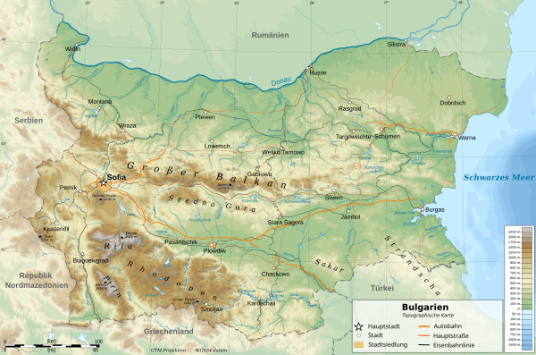
The Republic of Bulgaria is located in southeastern Europe on the eastern half of the Balkan Peninsula and borders in the north, mainly along the Danube , with Romania , in the west with Serbia and Macedonia , in the south with Greece and Turkey and in the east with the Black Sea .
In cultural terms, Bulgaria has always been on the borderline between European and Oriental influences.
physical geography
Natural structure

The country is divided by the Balkan Mountains ('Stara plani'na, Bulgar. Стара Планина = Old Mountains) (almost 2400 meters high) into the northern Danube Plain and the southern Upper Thracian Plain . The Strandscha and Sakar Mountains rise in the southeast and the Rhodope Mountains in the south . Pirin and Rila form the highest mountains in the country in the southwest. In the latter is the Rila Monastery (Bulgarian Рилски Манастир). The Sofia valley basin is also located in the west of the country . To the north of the Rila is the Vitosha Mountains and to the west Osogowo and Belasiza form the border with Macedonia and Greece. The geographic center of the country is in the Usana area in the Balkan Mountains. The coastline is 354 kilometers.
The country is divided into four main landscape zones from north to south.
- Northern Bulgarian plate south of the Danube
- Balkan Mountains (up to 2300 meters high)
- Central Bulgarian Basin
- Thracian mountain range in the south (up to 3000 meters high)
Bulgaria is further divided into altitude zones as follows:
| Altitude zone | Height (m) | Area (km²) | Surface (%) |
|---|---|---|---|
| Plains | 0-200 | 34.858 | 31.42 |
| hill | 200-600 | 45.516 | 41.00 |
| Smaller mountains | 600-1000 | 16,918 | 15.24 |
| Medium higher mountains | 1000-1600 | 10.904 | 9.82 |
| Higher mountains | 1600-2925 | 2,798 | 2.52 |
Orography
Of the total area of Bulgaria (110,910 km² ) 110,550 km² are land area, 360 km² are occupied by the sea (Black Sea). The lowest point is the Black Sea coastline at zero meters. The Musala in the Rila Mountains is with a height of 2,925 meters, the highest elevation of the country and the Balkan peninsula . The highest peak in Pirin -Gebirge is the Vihren and the highest point of the Balkan Mountains forms of Botev .
Waters
The longest river in Bulgaria is the Danube, which forms the northern border to Romania for almost 500 kilometers. The longest river in the country is the 368 kilometer long Iskar . Other larger rivers are the Mariza , Arda , Struma and Mesta with their tributaries, which originate in the Bulgarian mountains, form the most important rivers in Bulgaria.
In the country, a distinction is made between three catchment areas of the rivers, which flow into the Danube in the north, the Black Sea in the east and the Aegean Sea in the south . The largest rivers that flow northwards are Iskar, Ossam , Jantra , Timok . They arise in the Balkan Mountains or, like the Iskar, in the Rila Mountains. Smaller rivers such as Prowadijska, Kamchija , Ropotamo , Weleka or Resowo flow towards the east . The rivers Mesta , Struma, Mariza and Tundscha flow to the south .
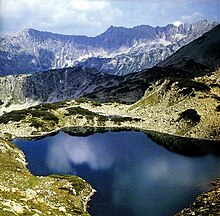
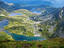
Among the most important lakes are the lakes around Burgas : the Atanasov Lake , the Lake Burgas , the Lake Pomorie , the Mandra Lake , and the Srebarna -See and devnya Lake . The largest lake in Bulgaria is the Burgas lake with 27 km². Other well-known lakes are the Seven Lakes in the western part of the Rila Mountains.
There are more than 600 hot and cold mineral and geothermal springs in Bulgaria.
Islands
Bulgaria mainly includes smaller islands that are located in the Danube and the Black Sea. The Danube has a total of 132 islands in the section between Romania and Bulgaria. Of these, 81 islands belong to Bulgaria and 51 islands to Romania. The three largest Bulgarian Danube Islands are Belene , Kozloduj (Козлодуй) and Wardim (Вардим). The largest Black Sea island is Sweti Iwan , others are Sweti Kirik i Julita , Sweta Anastasia and Snake Island .
Nature reserves and parks
National parks

The three national parks of Bulgaria together cover an area of 1920 square kilometers, i.e. H. 1.73 percent of the country's area.
- The Central Balkan National Park (bulg. Национален парк Централен Балкан , 71,670 hectares) extends over the middle and upper areas of the part of the Balkan Mountains in central Bulgaria . More than half of all Bulgarian plant species can be found here. The highest peak belonging to the park is the Botew with 2376 meters.
- Rila National Park (Bulgarian: Национален парк Рила , 81,000 hectares)
- Pirin National Park (bulg. Национален парк Пирин , 40,000 hectares)
Nature parks
Bulgaria has ten nature parks, which total an area of 2891 square kilometers and thus make up 2.6 percent of the country's area.
- The Balgarka Nature Park ( Българка , 21,772 hectares) extends over the northern slopes of the central Balkan Mountains and has existed since September 9, 2002. The park, which is 80 percent wooded (65% beech), includes the Schipka-Busludja and Museum the Etara open-air museum . Golden jackal, roe deer, badger, pine marten, wolf, brown bear, golden eagle and white-backed woodpecker are represented in the animal world.
- Shumen Plateau (3930 hectares)
- Rila Monastery (27,371 hectares)
- Rusenski Lom (49,629 hectares)
- The Persina Nature Park (21,762 hectares) extends along the Danube and primarily serves to protect the numerous islands.
- Sinite kamani (7095 hectares)
- The "Strandscha Nature Park" encompasses almost the entire Strandscha Mountains. With its area of 1161.36 square kilometers, the nature park occupies a good one percent of the country's territory, making it the largest nature reserve in Bulgaria. The park is divided into the five reserves Silkosija (Силкосия) , Vitanowo (Витаново) , Sredoka (Средока) , Tisowica (Тисовица) and Usunbodschak (Узунбосия) (also called Lopushna (Лопжак) .
- Vitosha (30,130 hectares)
- Wratschanski Balkans (30,130 hectares)
- Slatni pjassazi (1321 hectares)
Reservations
There are 55 reserves in total in Bulgaria. 16 of which were in 1977 as part of the UNESCO program "Man and Biosphere " ( Man and Biosphere - MAB ) to protect typical landscapes to biosphere reserves proclaimed.
climate
Despite its southern location, the Bulgarian climate is sometimes icy cold in winter, which can be attributed to the Siberian continental high, which with its air currents can cause permanent frost in Bulgaria for a few days. Nevertheless, depending on the weather, air masses from the Mediterranean area can reach Bulgaria and thus ensure a rapid increase in temperature and enable 20 ° C in February. The summers are generally hot and quite dry and do not end until the middle of September with the first consecutive days below 20 ° C. Autumn is a typical Indian summer and can be replaced by sudden frosts from the end of November, which then quickly mark the short and cold winter.
On the Black Sea coast there are usually only a few days with permafrost, while in the Danube plain the cold air can collect well and can ensure a large number of permafrost days. The same effect has the warm air masses in summer, which cause temperatures of up to 40 ° C in the Danube Plain and make it the hottest and most continentally climatic region of Bulgaria.
Political geography
Limits
The Bulgarian national territory covers approx. 110,910 km² with a population density of 70 inhabitants per km².
The total length of Bulgaria's land borders is 1808 km. Of this, the border with Romania accounts for 608 km, of which 470 km are defined by the river Danube, 318 km on the border with Serbia, 148 km on the border with Macedonia, 494 km and on the border with Greece and 240 km and the Border with Turkey. In the east, the length of the coast on the Black Sea is 354 km.
Administrative division

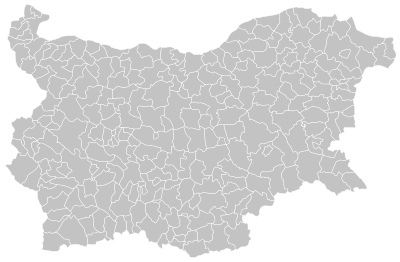
The Republic of Bulgaria is a central state, which is divided into 28 administrative districts (bulg. Област / Oblast) and 264 municipalities (bulg. Общини / Obstina). The largest oblast is the Burgas oblast , the largest obstina is the Sofia obstina .
See main article: Districts in Bulgaria
Biggest cities
Due to different counting methods, the results for the population figures of individual cities differ.
The 10 largest municipalities (as of December 14, 2006):
- Sofia 1,332,029 inhabitants
- Plovdiv 377,426 inhabitants
- Varna 353,716 inhabitants
- Burgas 229,307 inhabitants
- Russians 193,961 inhabitants
- Stara Sagora 182,413 inhabitants
- Pleven 162,124 inhabitants
- Sliven 147,557 inhabitants
- Pazardzhik 133,362 inhabitants
- Kardzhali 120,617 inhabitants
The 10 largest cities (as of December 14, 2006):
- Sofia 1,208,220 inhabitants
- Plovdiv 377,425 inhabitants
- Varna 346,565 inhabitants
- Burgas 213.096 inhabitants
- Russians 176,468 inhabitants
- Stara Sagora 162,927 inhabitants
- Pleven 137,374 inhabitants
- Dobrich 115,213 inhabitants
- Sliven 112,103 inhabitants
- Shumen 102,915 inhabitants
See also : List of cities in Bulgaria
Individual evidence
- ^ Federal Foreign Office - country database
- ↑ География на България, 2002, с.30
- ↑ Information about the Strandscha Nature Park Archive link ( Memento of the original from September 28, 2007 in the Internet Archive ) Info: The archive link was inserted automatically and has not yet been checked. Please check the original and archive link according to the instructions and then remove this notice.
- ↑ Structure of the Strandscha Nature Park Archive link ( Memento of the original from August 17, 2016 in the Internet Archive ) Info: The archive link has been inserted automatically and has not yet been checked. Please check the original and archive link according to the instructions and then remove this notice.
- ↑ List of biosphere reserves
-
↑ Population with postal address in the municipality are:
Head Office for Population Registration and Administrative Services :
Monthly updated table of the population by postal and actual address by district (Област) and municipality (Община) -
↑ Population with postal address in the city according to:
Head Office for Population Registration and Administrative Services :
Quarterly table of the population by postal and actual address by district (Област), municipality (Община) and town (Населено място)


