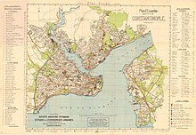
Geography of Istanbul


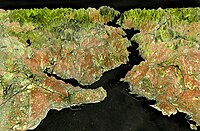
The geography of the Turkish city of Istanbul is characterized by the fact that it lies on both sides of the Bosphorus Strait . As the only one of the world's major metropolises , it is located at the interface between or on two continents , Asia and Europe . The city covers a slightly hilly area of 1,830.92 km². The bank edges to the Bosporus drop steeply and show a narrow, intensively used sedimentation surface.
The urban area of Istanbul has an extension of around 50 kilometers in north-south and around 100 to 120 kilometers in east-west. The historical core of the settlement area and the actual old town form the district of Fatih and the district of Eminönü on the tip of the peninsula of classical Byzantium. The province of Istanbul has an area of 5,343 square kilometers (for comparison Saarland = 2,569 km²). More than 12 million people live in the official urban area (2008). There are far more extensive estimates of the current population.
Geographical location

Marmara region
The Marmara region ( Turkish Marmara ) is with an area of 67,000 km² the smallest but most populous of the seven geographic regions of Turkey . The official name is "Marmara area" (tr. Marmara Bölgesi ). It represents about 8.6% of the Turkish state territory and comprises four sub-regions in the vicinity of Istanbul.
- Marmara region
- Yıldız Dağları Bölümü - Yıldız Mountains area
- Ergene Bölümü - area of the Ergene basin
- Güney Marmara Bölümü - area of the catchment area of the Marmara Sea in the south of the region
- Çatalca-Kocaeli Bölümü - area of the two peninsulas between the Marmara and Black Sea between Çatalca and Kocaeli
Eastern Thrace
Eastern Thrace or Turkish Thrace (Turkish Doğu Trakya or Trakya Bölgesi) is the part of modern Turkey that is located in the Balkans northeast of Greece and east of Bulgaria . Historically, the region is the eastern part of the Thrace countryside . As Rumelia (Turkish: Vilayet Rumeli) the Turks have called this part of the Ottoman Empire in contrast to Anatolia since the 15th century . The term was used by the Turkish administration until 1864 for the entire European part of the empire with the exception of Bosnia , Hungary and Morea . Eastern Rumelia , southern Bulgaria, became autonomous in 1878 and part of Bulgaria in 1885.
Today the province of Tekirdağ is bordered by the province of Istanbul in the east and the provinces of Edirne , Çanakkale and Kırklareli in the west .
Kocaeli
The province of Kocaeli with the capital İzmit connects to the area of Istanbul in the east.
Bursa
The province of Bursa in the west of Asia Minor lies across the Sea of Marmara 100 km south of Istanbul. In this province the Uludağ Mountains stand up.
Çanakkale
The province of Çanakkale with the provincial capital Çanakkale lies on the other side of the Sea of Marmara south of Istanbul. It lies with its smaller part on the European bank of the Dardanelles .
geology

Istanbul as a whole lies north of the North Anatolian Fault , which stretches from northern Anatolia to the Sea of Marmara. The eastern part is on the Anatolian plate , the western part on the Eurasian plate . The consequence are recurring strong earthquakes . Between 1711 and 1894, 66 major quakes have been documented in this area.
Landscapes
The Istanbul peninsula
A peninsula with an altitude of about 30 meters protects the Golden Horn harbor from the Marmara Sea. It is the core of the world metropolis. For millennia there have been rulers' palaces and large houses of God on their top. Today there are Hagia Sophia , the Blue Mosque and the Yeni Sarayı (New Palace), which was probably named Topkapı Sarayı in the 18th century (building history since 1453). The palace provides a panoramic view of many parts of Istanbul, the Sea of Marmara, the Bosphorus, its Asian shores and far into the Golden Horn. The importance of the court holding of a palace is easy to understand on it, as the succession of its four courtyards, each of which is secured by walls and its own gates, is still accessible by tourists on foot. Forerunner was u. a. the Great Palace (also Holy Palace ), seat of the Byzantine emperors since Theodosius II (408–450). It already covered an area of around 100,000 square meters and was spread over six terraces. Since the 10th century, the emperors resided mainly in the Blachernen Palace on the Golden Horn near the land wall . The Great Palace gradually fell into disrepair. As a sultan's palace, the Topkapı was not replaced until the middle of the 19th century by the Dolmabahçe Seraglio , built a little north on the Bosphorus in the style of European two-wing complexes. Today, the Topkapı is a major tourist attraction as a museum as well as an important cultural and landscape facility (part of the UNESCO World Heritage Site ). The southern waterline runs in an east-west direction, and then turns southwest at Tekirdağ towards the Dardanelles (western bank).
Waters
Rivers
Two rivers, the so-called "Sweet Waters of Europe", flow into the Golden Horn 2 km north of Eyüp .
Bosporus
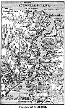
The Straits Bosporus (the Greek word for beef Erfurt was factually accurate and never can be meant only figuratively; an ancient term for this is "street of Konstantin Opel "). It connects the black and the Mediterranean in a north-south direction , more precisely the arm of the Marmara Sea. The Bosporus has a length of approx. 30 km and a width that varies between a minimum of 700 m and a maximum of 2.5 kilometers. Shipping traffic is internationalized with certain requirements and is subject to a pilot's recommendation.
Due to the different salinity, the water has two opposing currents: on the surface from the Black Sea to the Marmara Sea (due to the excess water; except for strong south winds) and a countercurrent at a depth of about 40 m; d. H. to the north there is a virtual ascent for the ship's engines.

Golden Horn

The Golden Horn is an 11 km long river that flows into the Bosporus and is on average 40 m deep. It reaches a maximum width of 800 m near the mouth. It has been known for a long time as a natural harbor with relatively little currents . It takes its name from the curved shape and the golden color of its water surface at sunset. In the past there were almost only shipyards, naval facilities and trading houses on the banks. Today, three road bridges and a railway bridge on the M2 underground line, including the underground station, cross the Golden Horn. Since 1974, the westernmost of these has been the Haliç Köprüsü motorway bridge (also Ayvansaray-Halıcıoğlu Köprüsü) roughly at the height of the land wall. The two bridges to the east are the Ataturk (1974) and, even better known, the pontoon bridge, which has been renewed again and again, Galata Bridge and Eminönü-Karaköy Köprüleri, on which, as with its predecessor buildings, fish restaurants below street level invite customers. Both have inner-city traffic functions between Fatih and Galata.
Sea of Marmara

The Sea of Marmara is a separate part of the Mediterranean that connects to it on the northeastern edge.
Via the two isthmuses / land bridges on its banks, the Bosporus (to the north) and the Dardanelles (to the southeast), it connects Europe and Asia or the Aegean with the Black Sea. This convenient location favored, among other things, the emergence of Istanbul on its north bank. Several historically significant cities adjoined its south bank (see article on Troy ; e.g. layers VI and VII). This continues on the west coast of Asia Minor south to Cape Lekton (with Babakale - Hamaxitos).
Lakes
These are among other reservoirs that supply Istanbul with water.
- Alibey Barajı (1983)
- Sazlıdere Barajı (1996)
Hydraulic engineering
- Water supply
- Water scarcity
- Channeling streams and rivers
- Flooding in heavy rain
- Antique water reservoir, cisterns
Ports
There are a variety of ports and landing stages. The main port in Üsküdar can be described.
At Yenikapı , overbuilt remains of the ancient port of Byzantium from the 4th century, including 32 well-preserved wrecks, were found after 2000. These are currently being scientifically processed.
Islands
- The nine Prince Islands ( Prens Adaları in Turkish ) are half an hour by sea southeast of the Bosphorus entrance in the Sea of Marmara and are a popular destination for city dwellers. The Prens Adaları , mostly just Adalar for short , have a total of around 14,000 inhabitants (2008, including Greek Orthodox monasteries). The larger ones are: Büyükada (Prinkipo-s), Heybeliada (Halki), Burgazada (Antigoni) and Kınalıada (Proti; because of its close proximity to the city), the smaller ones are called: Sedef Adası , Yassıada , Sivriada , Kaşık Adasi and Tavşan Adası .
- The Maiden's Tower (Turkish Kız kulesi, "Maiden's Tower") is a lighthouse from the 18th century, which is a few hundred meters from Üsküdar on a small island in the Bosphorus. Between it and a tower of the Mangana Palace , today near the western main train station, a large, then tense chain is said to have protected Byzantium on the lake side during attacks.
Traffic routes
Railway lines
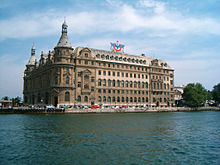
The railway line from Karaağaç (Edirne Province) runs from Esenyurt along the coastline of the Sea of Marmara in the south of old Istanbul to Sirkeci Garı , the railway terminus (e.g. historically the Orient Express ) below the Sultan's Palace. After an overnight stay in the Pera Palace Hotel, travelers from the west were able to take the ferry to Üsküdar and then continue their journey east from Haydarpaşa Garı .
This will change after the completion of the railway tunnel under the Bosporus, which according to plan is to connect the European and Asia Minor railway lines in Istanbul and Turkey from around 2014. The project is called Marmaray .
U- and S-Bahn system
In 2000 the first sections of the new underground / metro were opened; there is also the Hafif Metro Istanbul , a kind of light rail system or airport shuttle (opened in 1989).
In Galata there is also a very old, revived tram and an underground funicular, the Tünel (opened in 1875). A new building is the Füniküler Kabataş – Taksim , a funicular that also runs underground (opened in 2006 at Taksim Square )
Major roads
- D 100 = Edirne -İstanbul- Ankara
- Otoyol 1 = Osmaniye - Kadıköy (Inner Ring)
- Otoyol 2 = Kozyatağı (Kadıköy) - ( Fatih Sultan Mehmet Köprüsü ) - Mahmutbey (Bakırköy, Ataturk Airfield) (Outer Ring)
- Otoyol 3 = Edirne – İstanbul
- Otoyol 4 = Istanbul - İzmit - Düzce - Ankara
- D 110
- E 80: Kapitan Andreewo-Kapıkule –Istanbul (Bosporus or Fatih Bridge) –Ankara border crossing
Two suspension bridges cross the Bosporus, the older and more southerly of which is the Bridge of the Martyrs of July 15 (1973). It connects Ortaköy and the Beylerbeyi district . Both are multi-lane and toll roads.
The Fatih Köprüsü motorway bridge has been connecting the north-western district of Sarıyer (Rumeli Hisarı and Fatih-Sultan-Mehmet) and Beykoz since 1988 .
Political city structure

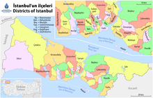
The administrative area of the metropolitan municipality ( Büyükşehir Belediyesi) Istanbul is divided into 39 districts, 25 of which are in the western and 14 in the eastern part of the city. The area of the city and province is largely identical:
cartography
An early view of the city has come down to us from Braun and Hogenberg in the 16th century. Constantinople is shown in a bird's eye view from the east. The then new Topkapi and the old town, bounded by the Theodosian land wall, are in the center. The Asian part and the Prince Islands only figure as the lower border. On the right edge of the picture, the gardens of Pera-Galata merge into the open landscape. On the left, two ships sail to the roadstead and one to the Mediterranean. On the lower bar there are medallions with the head images of the 11 sultans who had ruled there until then. The Hagia Sophia, still without minarets, appears small compared to the mosque in the new part of the city.
The view of the merchant town of Pera from the south, shown here in the upper right corner, also dates from this time.
- An inventory for the period from the Greek. Byzantium to Constantinople in the 15th century can be seen on this new map:
literature
- Georg Braun , Franz Hogenberg : Civitates orbis terrarum (cities of the world). 363 copper engravings with 564 city views reissued and commented by Stephan Füssel , Rem Koolhaas , Hist. Museum Frankfurt / M. after an original from the Historisches Museum Frankfurt. The original was published from 1572 to 1618. Taschen, Cologne, 2008, 520 pages. ISBN 978-3-8365-1125-4 - page 119 (based on a copy by Münster or Giovanni Andrea Valvassore, 1550 or n.d., there p. 940)
- Wolfgang Müller-Wiener: Pictorial dictionary on the topography of Istanbul. Byzantium - Constantinupolis - Istanbul until the beginning of the 17th century. Wasmuth Ernst Verlag, Tübingen, 1977. 534 pages. ISBN 3-8030-1022-5
See also
Web links
- Internet presence of the city administration of Istanbul (Turkish / English; e.g. with current map)
- Internet presence of the provincial administration of Istanbul (Turkish / English; among other things with current map)
Individual evidence
- ↑ Determination of Land Data of Ergene Basin (Turkey) by Planning Geographic Information Systems : "Ergene Basin is located in the middle of the Thrace region and surrounded by the borders of the Northern Marmara Basin, Meriç Basin and Bulgaria. Ergene Basin is one of the existing 13 sedimentation basins in Turkey. In terms of its geographical structure, it is in the form a basin closed to the sea. "
- ↑ Noyan Dinçkal: Istanbul and the water. On the history of water supply and sewage disposal from the middle of the 19th century to 1966. Oldenbourg, 2004. 325 pages. ISBN 978-3-486-57565-1
- ^ A never-ending story of Istanbul's 8,500-year history . In: Hurriyet , Feb. 1, 2009 (on the Byzantine harbor)
Coordinates: 41 ° 7 ′ 10 ″ N , 29 ° 4 ′ 31 ″ E


