
Barley
| coat of arms | Germany map | |
|---|---|---|

|
Coordinates: 50 ° 58 ' N , 10 ° 4' E |
|
| Basic data | ||
| State : | Thuringia | |
| County : | Wartburg district | |
| Height : | 205 m above sea level NHN | |
| Area : | 149.98 km 2 | |
| Residents: | 9100 (Dec. 31, 2019) | |
| Population density : | 61 inhabitants per km 2 | |
| Postal code : | 99834 | |
| Primaries : | 036922, 03691 (Clausberg), 036925 (Oberellen, Marksuhl, Burkhardtroda, Eckardtshausen, Förtha, Wolfsburg-Unkeroda), 036927 (Lauchröden, Unterellen) | |
| License plate : | WAK, SLZ | |
| Community key : | 16 0 63 097 | |
| LOCODE : | DE GTE | |
| Community structure: | 11 districts | |
| Address of the municipal administration: |
Wilhelmstrasse 53 99834 Gerstungen |
|
| Website : | ||
| Mayoress : | Sylvia Hartung | |
| Location of the municipality of Gerstungen in the Wartburg district | ||
  |
||

Gerstungen is a municipality in the Wartburg district in Thuringia ( Germany ). As a result of the merger with the communities of Wolfsburg-Unkeroda and Marksuhl on July 6, 2018, Gerstungen is the largest community in Thuringia and with around 9100 inhabitants, it is the most populous community in Thuringia without municipal rights.
geography
The municipality of Gerstungen is located in the west of the Free State of Thuringia, right on the border with Hesse . Neighboring communities are Herleshausen ( Werra-Meißner-Kreis , Hessen) in the north, the independent city of Eisenach in the northeast, Wutha-Farnroda and Ruhla in the east, Moorgrund in the southeast, Bad Salzungen and Werra-Suhl-Tal in the south and Wildeck ( Hersfeld- Rotenburg , Hessen) in the west.
The municipal area between the Richelsdorf Mountains in the west and the Thuringian Forest Nature Park in the east is traversed by the Werra . The most important tributaries of the Werra in the municipality are the II order waters Elte , Weihe and Suhl .
history

No written evidence is available for the early history of Gerstungen. The ending -ungen indicated how similar ending -ingen , a Germanic foundation back, but can this uncertain evidence. A donation from Gerstungen to the Fulda Monastery, founded in 744 by the Franconian King Karlmann, is mentioned in the Codex Eberhardi , which dates from the 12th century, and is the first documented mention.
Heinrich IV was in Gerstungen several times during the Saxon War. In 1074 negotiations between the rebellious Saxon and Thuringian nobility and the king took place here. Finally the peace of Gerstungen was concluded. The king had to agree to the destruction of his castles in Northern Thuringia and in the Harz Mountains. The Lords of Gerstungen were first mentioned in 1174.
The former castle was protected on three sides by moats. At that time, it was used to secure the Werra crossing, a ford on the " Kurzen Hessen " .
In the middle of the 14th century, the office of Gerstungen was created by the diocese of Fulda , which from 1402 onwards went to the Landgraves of Thuringia and ultimately to the Duchy of Saxony-Eisenach as a pledge, but ultimately permanently . The present districts of Gerstungen, Untersuhl and Neustädt belonged to him. The places Lauchröden, Sallmannshausen and Unterellen belonged to the territory of the neighboring Brandenburg , they were therefore mentioned as belonging to the Brandenburg courts . Administratively, the three places belonged to the Wettin office of Wartburg (Saxony-Eisenach). The place Oberellen formed with several courtyards an exclave of the Duchy of Saxony-Meiningen .
As a result of a fire, the Katharinenkirche had to be renewed in 1588; its predecessor building, located in the same place, also served as a castle church.
When Gerstungen came to Duke Ernst August I of Saxe-Weimar-Eisenach in 1741 , only the outworks of the castle remained. The moated castle was in ruins. The new sovereign acquired the Knobelsdorfchen garden and combined it with the Vorwerk to form the chamber property . The stables were enlarged and the construction of the castle planned. The foundation walls of the medieval moated castle were used to build the castle in the 17th and 18th centuries, which was later the seat of the Gerstungen office and is now a local museum.
During the Second World War 550 prisoners of war from the Soviet Union had to do forced labor in the construction of the motorway bridge over the Weihetal . Another 90 workers were employed in smaller companies and in agriculture. 53 workers were forced to work in Oberellen . Since 1977, a memorial in the Untersuhl cemetery has been commemorating 107 victims of forced labor .
On July 20, 1944, an American air raid with 226 explosive bombs took place on Gerstungen train station and its surroundings. There were 11 dead and several injured among the population.
On September 13, a shot down US bomber B 17 (“Flying Fortress”) crashed near Neustädt while attempting an emergency landing . Eight crew members were killed in the explosion and one was saved.
On September 27th, the center of the "Air Battle of Thuringia" was between the communities Gerstungen, Herleshausen, Lauchröden and Richelsdorf. A total of 30 US B 24 bombers were shot down, many crashed in the region. 29 German fighters were also lost.
The US Army occupied Gerstungen itself, after artillery fire and low-flying attacks, without resistance on April 1, 1945. Most of the residents had fled to the forest or the rest of the area. A German anti-aircraft unit fired at the Americans from the “forest” as they crossed the Werra Bridge, which was only partially destroyed by blasting. Eight of the Wehrmacht soldiers who died in the fight were buried in the Gerstung cemetery. The graves were leveled during the GDR era, in the 1970s.
At the beginning of July 1945, Gerstungen, like all of Thuringia, was handed over by the Americans to the Red Army . It became part of the Soviet occupation zone and, in 1949, of the GDR . From 1961 Gerstungen was in the 5-kilometer restricted area on the zone border.
The station Gerstungen from 1963 to 1990, the third largest border station of East Germany . From 1961 it was expanded from a marshalling yard to a control station, including track closures. In September 1961, the Central Committee of the SED gave instructions to build the Reichsbahn alternative route Gerstungen – Förtha (13 km) so that the Thuringian tip with an escape route for GDR citizens no longer had to be crossed.
Incorporations
Untersuhl was incorporated on January 1, 1960. Neustädt and Sallmannshausen followed on March 8, 1994. On March 16, 2004, the formerly independent towns of Lauchröden, Oberellen and Unterellen were incorporated. On July 6, 2018, the communities of Marksuhl and Wolfsburg-Unkeroda were incorporated.
Population development
Development of the population:
|
|
|
|
- Data source: from 1994 Thuringian State Office for Statistics - values from December 31st
² after the incorporation of Marksuhl and Wolfsburg-Unkeroda
coat of arms
The partially speaking image has been found in the seals of the community since the 18th century. The heraldic animal of Gerstung - the stork - has nested in Gerstungen on the castle from time immemorial. It also symbolizes the typical plant-animal community (river valley with laughter). The stalk in the bird's beak is barley, which is included in the place name and has been cultivated since agriculture has been practiced here. Straw stands for the stork's nest on the castle; the green background symbolizes the Werra lowland and the wavy ribbon the Werra - the wavy ribbon is intended to represent the districts of Neustädt and Sallmannshausen.
Community structure

(Population figures as of December 31, 2016)
- Gerstungen (3.242) with Untersuhl and Lutzberg
- Leeks (916)
- Oberellen (829) with Clausberg , Frommeshof and Hütschhof
- Unterellen (518)
- Neustadt (256)
- Sallmannshausen (118)
- Marksuhl with building yard , Mölmeshof , Josthof , Meileshof and Lindigshof (1,306)
- Burkhardtroda (260)
- Förtha with Epichnelles (742)
- Eckardtshausen with Wilhelmsthal (505)
- Wolfsburg-Unkeroda (706)


politics
Municipal council
After the local elections in Thuringia in 2019, the local council in Gerstungen will consist of 20 council members.
- Citizens' community of voters for the municipality: 6 seats
- CDU : 4 seats
- SPD / Free Voters : 4 seats
- LINKE / Gerstungen community of voters: 2 seats
- LAD : 2 seats
- Free voters Wolfsburg-Unkeroda: 1 seat
- FDP : 1 seat
(As of: local election on May 26, 2019 )
After the incorporation of the communities of Marksuhl and Wolfsburg-Unkeroda in July 2018, a transitional community council was formed to which 32 elected officials belonged. This lasted until the 2019 municipal council election.
mayor
In the mayoral election on May 22, 2016, Sylvia Hartung (SPD / FW) won with 76.7% of the valid votes. Her term of office began on July 1, 2016.
Parish partnership
Economy and Infrastructure

Commercial areas
In Gerstungen there are companies in the metal processing industry, the manufacture of building materials and plastic products, wood processing, electrical parts production and service companies. The ae group , a foundry company and supplier for the automotive industry, is based in Gerstungen. In the core town of Gerstungen, the most important commercial location, there are five commercial areas and one industrial area, and a sixth commercial area is being planned. The largest industrial area Above the Bahn with a total area of around 24 hectares is located on the north-western outskirts of Gerstungen, the Auf der Höhe industrial area with a total area of 11.2 hectares is located on the western outskirts of Untersuhl.
In the Unterellen district there is the Auf der Aue industrial park and a larger farm. In the 20.48 hectare industrial area Im Meilesfelde on the eastern outskirts of Marksuhl, international companies in mechanical engineering and metal processing have settled.
Rail transport

The municipality of Gerstungen has a total of three train stations: Gerstungen , Marksuhl and Förtha (Eisenach) . The station Gerstungen was formerly inner German border station on the railway line Halle-Bebra . Until the border station lost its function in 1990, it had more than 25 tracks, several covered platforms and a depot with three locomotive sheds and a water tower.
Since December 2006, cantus Verkehrsgesellschaft has been using the regional line R6 Eisenach –Gerstungen– Bebra . In the districts of Förtha and Marksuhl there are train stations on the Eisenach – Lichtenfels railway line .
Road traffic
Gerstungen is on the federal highway 4 Frankfurt am Main - Dresden with a junction named after the place . Because of the inner-German border and the unfinished valley bridges at Wommen and Untersuhl as a result of the border demarcation , traffic in the section known as the Thuringian Zipfel could only be started at the beginning of the 1990s; previously the B 400 was used as a bypass on the Hessian side . The municipal area is cut through at Marksuhl and Förtha by the federal road 84 . In the far east of the municipality near Wilhelmsthal, the federal road 19 runs .
Bus routes from various companies connect Gerstungen and its districts with the neighboring communities as well as with Bad Salzungen and Eisenach .
Attractions
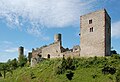
- Brandenburg ruins near Lauchröden
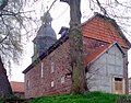
- Gerstungen Castle with the Werra Valley Museum and stork's nest
- the Katharinenkirche is the Protestant parish church
- the round church Untersuhl
- the Catholic Church
- the Gerstunger town hall with park
- the Gerstung market square with the stork fountain
- the Limpertstein , an ancient monument, according to legend it is a slain servant of the nearby ruins of Brandenburg
- the legendary Mühlvaltenstein on the northern outskirts
- the Kohlbachshäuschen - a historic hunting lodge in the Gerstung forest .
- the Böller - the Sallmannshäuser Rennsteig runs through the extensive forest area in the east , on the southern edge is the lonely district of Lutzberg
- the historic draw well in the Gerstungen district of Neustädt
- the Schweddrich , an unusual fishing facility at the mill in the Gerstunger district of Sallmannshausen
- Marksuhl Castle , built between 1587 and 1591 by Prince Johann Ernst
- St. Hubertus Church , built in 1454
- Wilhelmsthal Palace , former summer residence of the Dukes of Saxe-Weimar, with a park designed by Eduard Petzold

The castle of Unterellen
Sallmannshausen Church
Lauchröden, Brandenburg

The renaissance castle Marksuhl, built between 1581 and 1591

St. Hubertus Marksuhl Church


Kohlbachtal nature reserve
The Kohlbachtal nature reserve is located about one kilometer west of Gerstungen. The area stretching over four kilometers along the Kohlbach is a very species-rich and diverse habitat. In 1997 the area was scientifically investigated. The dominant plant communities include the alder floodplain forest, reed beds and large sedge beds. With the support of the Gerstungen-Marksuhl Forestry Office, it was possible within a short period of time to restore the edge areas of the spruce monoculture of the commercial forest. There are numerous rest areas and information boards along the main hiking trail. The Kohlbachtal with the Kohlbach Born and the Kohlbach hunting lodge is one of the most popular local recreation areas for Gerstunger. The BUND , district association Wartburgkreis and the city of Eisenach designated the area as biotope of the month August 2001 .
Sons and daughters of the place
- Friedrich Moritz Stapff (1836–1895), geologist
- Gustav Humpf (1881–1959), linguist, author of Latin and French grammars
- Liesel Herbach (1912–1986), painter and draftsman, local researcher
- Wilfrid Bach (1936–2015), geographer and climatologist
- Peter Schmidt (1939–1999), geoscientist and librarian
- Heino Apel (* 1942), education, development and environmental economist
- Ernst Kranz (* 1950), politician (SPD), member of the Bundestag 2002–2009
- Reinhold Brunner (* 1961), archivist and historian
Other people who worked on site
- Hermann Otto Stölten (1896–1928), pastor, local researcher and founder of the foreign and beautification association as well as the high school
Web links
- www.gerstungen.de - official homepage of the community
Individual evidence
- ^ Population of the municipalities from the Thuringian State Office for Statistics ( help on this ).
- ↑ Thomas Bienert: Medieval castles in Thuringia. Wartberg Verlag, 2000, ISBN 3-86134-631-1 , p. 324.
- ↑ Michael Köhler: Thuringian castles and fortified pre- and medieval living spaces. Jenzig-Verlag, 2001, ISBN 3-910141-43-9 , pp. 108-109.
- ↑ Heiko Laß: Hunting and pleasure castles of the 17th and 18th centuries Michael Imhof Verlag 2006, ISBN 3-86568-092-5 , pp. 318-319.
- ↑ Thuringian Association of the Persecuted of the Nazi Regime - Association of Antifascists and Study Group of German Resistance 1933–1945 (Ed.): Heimatgeschichtlicher Wegweiser to places of resistance and persecution 1933–1945 , Heimatgeschichtliche Wegweiser, Volume 8 Thuringia, Erfurt 2003, ISBN 3-88864 -343-0 , p. 323.
- ^ Rainer Lämmerhirt: The fight for the Werra line . Publishing house Rockstuhl, Bad Langensalza. 2nd edition 2005. ISBN 3-937135-64-2 . P. 52.
- ↑ Dieter Schneberger: Hope sprouted five times a day at the Bebra railway junction . Train traffic in the "Cold War". In Gerstungen, the marshalling yard is being converted for control purposes. Thuringian regional newspaper, August 13, 2011.
- ↑ a b Municipalities 1994 and their changes since January 1st, 1948 in the new federal states , Metzler-Poeschel publishing house, Stuttgart, 1995, ISBN 3-8246-0321-7 , publisher: Federal Statistical Office.
- ^ StBA: Changes in the municipalities in Germany, see 2004
- ↑ Law and Ordinance Gazette for the Free State of Thuringia of July 5, 2018. Accessed on July 6, 2018 .
- ↑ Hartmut Ulle: Thuringian Wappenbuch ; Arbeitsgemeinschaft Genealogie eV (publisher).
- ^ Unified community Gerstungen - Gerstungen. Retrieved July 6, 2018 .
- ^ Community of Marksuhl - location & facts - Marksuhl, Burkhardtroda, Eckardtshausen, Förtha. Retrieved July 6, 2018 .
- ↑ Elections of the community and city council members. Preliminary results. The regional returning officer, accessed on May 29, 2019 .
- ↑ Katja Schmidtberger: the largest community in the district faces major tasks , Thüringer Allgemeine / Eisenacher Allgemeine from August 18, 2018, accessed online on August 23, 2018
- ^ Thuringian State Office for Statistics: Elections in Thuringia. In: www.wahlen.thueringen.de. Retrieved May 31, 2016 .
- ↑ Sylvia Hartung - The official result has been available since ... | Facebook. In: www.facebook.com. Retrieved May 31, 2016 .
- ↑ http://www.gerstungen.de/stati /wohnen.shtml
- ^ Klaus Fink: "Kohlbachtal" nature reserve near Gerstungen. Biotope of the month August 2001 . In: MFB Verlagsgesellschaft mbH Eisenach (ed.): StadtZeit. City journal with information from the Wartburg district . September issue. Druck- und Verlagshaus Frisch, Eisenach 2001, p. 40-41 .
- ↑ Fredy Richter: Hermann Otto Stölten: His life. His work. His time ; C-graphics and printing: G. Richter, 1997; Custom-made in-house publishing; Pp. 17-74.
Office of Creuzburg | Bad Liebenstein | Bad Salzungen | Barchfeld-Immelborn | Berka vd Hainich | Bischofroda | Buttlar | Dermbach | Empfertshausen | Frankenroda | Geisa | Barley ground | Barley | Hallings | Hörselberg-Hainich | Krauthausen | Krayenberg Community | Lauterbach | Leimbach | Moorgrund | Nazza | Oxen | Ruhla | Schleid | Seebach | Treffurt | Unterbreizbach | Vacha | Weilar | Werra-Suhl Valley | Wiesenthal | Wutha Farnroda
Burkhardtroda | Eckardtshausen with Wilhelmsthal | Förtha with Epichnelles | Gerstungen with Untersuhl and Lutzberg | Leeks | Lindigshof | Marksuhl with Baueshof , Josthof , Meileshof and Mölmeshof | Neustädt | Oberellen with Clausberg , Frommeshof and Hütschhof | Sallmannshausen | Unterellen | Wolfsburg-Unkeroda