
Gries (Palatinate)
| coat of arms | Germany map | |
|---|---|---|

|
Coordinates: 49 ° 25 ' N , 7 ° 24' E |
|
| Basic data | ||
| State : | Rhineland-Palatinate | |
| County : | Kusel | |
| Association municipality : | Upper Glantal | |
| Height : | 280 m above sea level NHN | |
| Area : | 4.03 km 2 | |
| Residents: | 1067 (Dec. 31, 2019) | |
| Population density : | 265 inhabitants per km 2 | |
| Postal code : | 66903 | |
| Area code : | 06373 | |
| License plate : | KUS | |
| Community key : | 07 3 36 032 | |
| Association administration address: |
Rathausstrasse 8 66901 Schönenberg-Kübelberg |
|
| Website : | ||
| Local Mayor : | Olaf Klein ( SPD ) | |
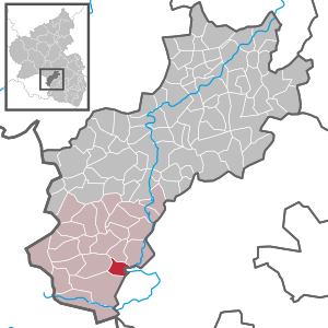
| Location of the local community Gries in the Kusel district | ||
  |
||

Gries is a municipality in the Kusel district in Rhineland-Palatinate . It belongs to the community of Upper Glantal .
geography
Gries is located on the edge of the North Palatinate Bergland (part of the Saar-Nahe Bergland), on the southern slope of the 314 m high Schlossberg in the Western Palatinate . In the south lies the Ohmbach valley with the 10 to 18 ha large Ohmbach reservoir and in the east the Glan has cut into the North Palatinate uplands with a distinctive loop where the river turns north.
In the north there is Börsborn , in the east Elschbach (district of Bruchmühlbach-Miesau in the district of Kaiserslautern ), in the west there is bridges and in the southwest there is Schönenberg-Kübelberg , namely the district Sand .
history
middle Ages
Gries was first mentioned in a document in 1383 in the so-called Breidenborner Kopialbuch . In this entry, the communities of the Münchweiler valley (an administrative unit belonging to the Hornbach monastery near Zweibrücken ) take an oath of allegiance for their new mistress, Agnes von Neuenbaumberg, who is around 300 years older.
Gries probably originated at the turn of the 11th to the 12th century. The name “zuom ´griss” (as the original version) means gravelly, sandy soil in Middle High German and the addition “zum” can be seen as the field name of another municipality. These were separated from the original location , probably in connection with the introduction of three-field farming . Kübelberg is the closest community that already existed at the time. At the same time as Gries, the communities Sand (zuom sand), Schönenberg and Miesau were probably created, even if different foundation dates (which are based on a coincidental mention) are given for all communities.
The highest sovereign of the Münchweiler Valley or Münchweiler Office was the Hornbach Monastery . This most important Benedictine monastery east of the Rhine and south of the Nahe did not administer its widespread possessions itself, but gave them to various vassals as fiefs. After the aforementioned Raugrafen von Alten- and Neuenbaumburg , the Breidenborner followed, then the Mauchenheimer. In the 15th century, the Counts von der Leyen came into the partial and later complete possession of Gries and the other municipalities of the Münchweiler office ( Glan-Münchweiler , Nanzweiler , Dietschweiler , Börsborn , Steinbach , Haschbach ) through marriage . Jörg von der Leyen married a daughter from the venerable Zweibrücken noble family of Mauchenheimer . Since they had a share in the possession of the Ganerbe Castle Blieskastel , Gries and the other municipalities of the office became part of the Blieskastel Upper Office and remained so for around 300 years until the French Revolution.
The supreme sovereign changed, however. The previous patrons of the Hornbach Monastery, the Dukes of Pfalz-Zweibrücken, took over the sovereignty after the monastery was gradually abandoned by the monks during the Reformation and even the last abbot Johann Kinthausen married and became a Protestant. Since the von der Leyen remained with the old faith - after all, their family, who came from Gondorf on the Moselle, had several Archbishops of Trier and Mainz - there were several disputes on religious issues with the Zweibrücken dukes, who had initially converted to Protestantism. These conflicts often ended before the Reich Chamber of Commerce in Speyer or Wetzlar .
From the Palatinate War of Succession to 1945
As a result of the War of the Palatinate Succession , the French under Louis XIV not only occupied the Electoral Palatinate territories, but also the numerous other small and micro-states of the Palatinate, so that they practically had the say. On the other hand, the dukes of Zweibrücken had married into the Swedish royal family. The result was that Pfalz-Zweibrücken was temporarily administered from there. The oldest map on which Gries appears (made in 1564 by the geometer Tilemann Stella, quasi as an illustration of his description of the offices of Zweibrücken and Kirkel) is, for example, in the Swedish National Archives in Stockholm. The balance of power was to change often over the centuries. Only the membership in the rule of the counts (later imperial counts) von der Leyen as feudal men of the respective supreme rulers remained the same.
A few decades after the von der Leyen relocated their main residence from Koblenz to Blieskastel and expanded this small town on the Blies in a representative manner, French troops marched in during the French Revolution. The last, legendary and popular Countess Marianne von der Leyen was able to escape via Karlsberg Castle and Glan-Münchweiler in an adventurous, film-like escape to relatives in Hessen on the right bank of the Rhine . After Napoleon's defeat at the Battle of Leipzig (1813) and the Allies captured the Left Bank of the Rhine until the beginning of 1814, the French stayed .
After the regulation at the Congress of Vienna (1815), the Palatinate finally came to Bavaria in 1816 after several transitional phases (e.g. the joint Austrian-Bavarian state administration ) . The achievements of the French Revolution, such as freedom of trade and the press, independent courts, modern administration, equality of all citizens, etc. were preserved especially for the Palatinate. Gries was part of the Landes-Commissariat Homburg (then Rheinkreis , now Saarland), whose first chief boss was Philipp Jakob Siebenpfeiffer . At that time still a loyal supporter of the Bavarian king (incidentally all descendants of Palatine Wittelsbachers; the Bavarian cousins died out in the middle of the 18th century), he was one of the main initiators of the Hambach Festival in 1832 , the most important demonstration for democracy in the Germany of the pre-march.
In 1848 the communities of Sand and Gries separated from the mayor's office in Schönenberg and until 1954 they had their own communal administration. Up until 1920, Gries was part of the Homburg District Office, as the Land Commissioner was later called. Then a brutal dividing line was drawn through the middle of the long, harmoniously grown administrative unit due to the Treaty of Versailles . The western part with the coal mines and the iron and steel industry, in which the majority of the citizens of Gries earned their bread, came to the Saar area under League of Nations administration , including the district capital Homburg. The eastern part remained with the "Reich". The canton of Waldmohr was just as separate as the entire district office. Even the mayor's office of Waldmohr with Waldmohr and Jägersburg was torn apart.
After the Second World War
With the end of the Second World War and the formation of the new state of Rhineland-Palatinate , the affiliation to Bavaria that had existed until then also ended.
Since 1919/1920 Gries belonged to the district of Kusel ; the former Homburg canton of Waldmohr was granted a special status as a district office branch of the Kusel district office until the end of the Second World War. Incidentally, the relations to Homburg are still closer today than to today's district town Kusel , and not only because it is about twice as far away as Homburg.
The administrative community with sand ended after some, from today's perspective, amusing intermediate steps in 1954. Sand now became part of the municipal administration of Schönenberg. Gries remained independent to this day. The administrative business was taken over from 1972-2016 by the Verbandsgemeinde Schönenberg-Kübelberg and since 2017 by the Verbandsgemeinde Oberes Glantal .
In addition to the "establishment" of the Ohmbachsee by 1978, the partnership concluded in 1979 with the municipality of Gries in the Alsatian department of Bas-Rhin is an important date in the recent history of the village. Gries has a close relationship with this community, not only on the public side, but also in the private sphere.
Since 1972, large new building areas have been developed, stretching from the old town center to the TuS Gries sports field, which has long been surrounded by wide, agriculturally used areas. Another new development area at the southwest end of the village on "Hutschwaldstraße" has been developed since 2012 and, with a few exceptions, has been developed.
politics
Municipal council
The local council in Gries consists of 16 council members, who were elected in a personalized proportional representation in the local elections on May 26, 2019 , and the honorary local mayor as chairman.
The distribution of seats in the municipal council:
| choice | SPD | FWG | total |
|---|---|---|---|
| 2019 | 10 | 6th | 16 seats |
| 2014 | by majority vote | 16 seats | |
| 2009 | 9 | 7th | 16 seats |
| 2004 | 7th | 9 | 16 seats |
- FWG = Free Voting Group “Citizen Near” e. V.
mayor
- 1848–1874 Jakob Pflüger, Sand
- 1874–1887 Nikolaus Ulrich, Sand
- 1887–1918 Philipp Vollmar
- 1918–1933 Jakob Christmann
- 1933–1937 Ernst Gortner
- 1937–1939 Ernst Scheck
- 1939–1945 Otto Fuhrmann
- 1945 Reinhard Rubly, Sand
- 1946 August Bauer, Sand
- 1946 Eduard Müller, Sand
- 1946/47 Eduard Spieß, Sand
- 1947–1952 August Bauer, Sand
- 1953–1967 Karl Kallenbach (Kallenbach voter group)
- 1967–1977 Eugen Bernd ( SPD )
- 1977–1999 Ludwig Jung (SPD)
- 1999-2004 Gunther Jung, (SPD)
- 2004–2009 Manfred Perschke, (Free Voting Group “Citizen Near” eV)
- 2009-2014 Gerd Heinz (SPD)
- since 2014 Olaf Klein (SPD)
In the direct election on May 26, 2019, Olaf Klein was confirmed in his office as local mayor for another five years with a share of the vote of 76.20%.
Partner communities
A partnership has existed with Gries (Bas-Rhin) in northern Alsace (about six kilometers to Hag (u) enau and twelve kilometers to the European city of Strasbourg) since May 20, 1979. The partnership has developed well since its inception. Due to the relative proximity (approx. 110 km), private contacts can also be maintained. A mixed Palatine-Alsatian marriage with children also emerged from it. Mutual visits by both municipal councils and other public institutions of the respective local associations are routine.
Economy and Infrastructure
The A 6 is to the southeast and the A 62 to the northeast . In Glan-Münchweiler there is a train station on the Landstuhl – Kusel railway line . Motorway connections to the A 6 Mannheim-Saarbrücken are in Bruchmühlbach-Miesau (district Miesau) and between Waldmohr and Homburg-Bruchhof (Waldmohr-Schönenberg-Kübelberg). The closest train station is that of Bruchmühlbach-Miesau (distance six kilometers), the most popular station is Homburg with an ICE connection.
literature
- Literature on Gries in the Rhineland-Palatinate State Bibliography
Web links
- Website of the local community Gries
- Local community Gries on the website of the Verbandsgemeinde Oberes Glantal
Individual evidence
- ↑ State Statistical Office of Rhineland-Palatinate - population status 2019, districts, communities, association communities ( help on this ).
- ^ The Regional Returning Officer Rhineland-Palatinate: Local elections 2019, city and municipal council elections
- ↑ The Regional Returning Officer Rhineland-Palatinate: direct elections 2019. see Upper Glantal, Verbandsgemeinde, ninth line of results. Retrieved May 5, 2020 .

Adenbach | Albessen | Altenglan | Altenkirchen | Aschbach | Bedesbach | Blaubach | Börsborn | Bosenbach | Breitenbach | Bridges (Palatinate) | Buborn | Cronenberg | Deimberg | Dennweiler-Frohnbach | Dittweiler | Dunzweiler | Ehweiler | Oiling | Elzweiler | Erdesbach | Eßweiler | Etschberg | Föckelberg | Frohnhofen | Ginsweiler | Glan-Münchweiler | Glan bridges | Semolina | Grumbach | Haschbach am Remigiusberg | Hausweiler | Hefersweiler | Heinzenhausen | Henschtal | Herchweiler | Herren-Sulzbach | Herschweiler-Pettersheim | Hinzweiler | Hohenöllen | Homberg | Hoppstädten | Horschbach | Hüffler | Jettenbach | Kappeln | Kirrweiler | Konken | Körborn | Kreimbach-Kaulbach | Krottelbach | Kusel | Langenbach | Boring | Lauterecken | Lohnweiler | Matzenbach | Medard | Merzweiler | Nanzdietschweiler | Nerzweiler | Neunkirchen am Potzberg | Lower albums | Niederstaufenbach | Nussbach | Top albums | Oberstaufenbach | Oberweiler im Tal | Oberweiler-Tiefenbach | Odenbach | Offenbach-Hundheim | Ohmbach | Pfeffelbach | Quirnbach / Palatinate | Rammelsbach | Rathsweiler | Rehweiler | Reichweiler | Reipoltskirchen | Relsberg | Rothselberg | Ruthweiler | Rutsweiler am Glan | Rutsweiler an der Lauter | Saint Julian | Schellweiler | Schönenberg-Kübelberg | Selchenbach | Steinbach am Glan | Thallichtenberg | Theisbergstegen | Ulmet | Unterjeckenbach | Delusional | Forest black | Welchweiler | Wiesweiler | Wolfstein