Great Peetschsee
| Great Peetschsee | ||
|---|---|---|
| Geographical location | District of Mecklenburg Lake District , Mecklenburg-Western Pomerania , Germany | |
| Tributaries | Canal ( Müritz-Havel waterway ) from the Vilzsee | |
| Drain | Canal (Müritz-Havel waterway) to Labussee | |
| Location close to the shore | Diemitz | |
| Data | ||
| Coordinates | 53 ° 12 '19 " N , 12 ° 51' 16" E | |
|
|
||
| Altitude above sea level | 58.5 m above sea level NHN | |
| surface | 12 ha | |
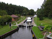
The Große Peetschsee is a lake one kilometer east of the Mirow district of Diemitz in the Mecklenburg Lake District in Mecklenburg-Western Pomerania. The lake name is derived from the Slavic word pêsŭkŭ for sand .
The maximum size of the pear-shaped lake is 320 meters × 500 meters, with a water depth of over five meters. The water level is 58.5 m above sea level. NHN .
The lake has an inflow via a canal in the northwest of the Vilzsee . The outflow in the east forms a canal with the Diemitz lock to the Kleine Peetschsee , 500 meters east below the lock , to which the Labussee connects 400 meters east . This fairway on the northern edge is part of the 32-kilometer-long federal waterway Müritz-Havel waterway of waterway class I, to which the lake also belongs. The Eberswalde Waterways and Shipping Office is responsible .
See also
Individual evidence
- ^ The Slavic place names in Meklenburg in the year books of the Association for Mecklenburg History and Archeology . - Vol. 46 (1881), p. 105
- ↑ Directory E, Ser. No. 36 of the Chronicle ( Memento of the original from July 22, 2016 in the Internet Archive ) Info: The archive link was inserted automatically and has not yet been checked. Please check the original and archive link according to the instructions and then remove this notice. , Federal Waterways and Shipping Administration

