Hörselberge
| Hörselberge | ||
|---|---|---|
| Highest peak | Great Hörselberg ( 484.2 m above sea level ) | |
| location | Wartburgkreis , Thuringia , Germany | |
| Foothills of the | West Thuringian mountain and hill country | |
| Classification according to | Handbook of the natural spatial structure of Germany | |
|
|
||
| Coordinates | 50 ° 57 ′ 13 ″ N , 10 ° 27 ′ 40 ″ E | |
| rock | Shell limestone | |
| surface | 6 km² | |
The Hörselberge are one to 484.2 m above sea level. NHN high and about 6 km² mountain range near Eisenach in the Wartburg district , western part of Thuringia .
geography
location
The distinctive and partly wooded Hörselberge are part of the border of the Thuringian Basin and border the basin landscape of the West Thuringian mountain and hill country south- west of the actual Thuringian Basin . They extend in an east-south-east direction about 5 to 11 km (as the crow flies ) east-south- east of Eisenach in the area of the communities Hörselberg-Hainich (in the east and north) and Wutha-Farnroda (in the west).
Not far north of the Hörselberge are the Eichsfeld-Hainich-Werratal Nature Park and the Hainich National Park , while the Thuringian Forest Nature Park extends to the south .
Surveys
The Hörselberge include the following elevations, side knolls and spur-like slope areas - sorted by height in meters (m) above sea level (NHN), with the names of the districts (G.):
- Great Hörselberg ( ⊙ ; 484.2 m ); G .: Hastrungsfeld
- Großer Herrenberg ( ⊙ ; 452 m ); G .: Burbach and Melborn
- Kleiner Hörselberg ( ⊙ ; 436.2 m ); G .: Wutha, Kahlenberg, Großenlupnitz, Wenigenlupnitz
- Kleiner Herrenberg ( ⊙ ; 430.7 m ); G .: Burbach and Melborn
- Alte Wacht ( ⊙ ; 416.6 m ); G .: Hastrungsfeld
- Herrenberg ( ⊙ ; 366.2 m ); G .: Burbach and Kahlenberg
- Huhrodt ( ⊙ ; 368.6 m ); G .: Melborn
- Hühnerberg ( ⊙ ; 360 m ); G .: Melborn
- Trenkelberg ( ⊙ ; 327.7 m ); G .: Grossenlupnitz
- Sperrlingskuppe ( ⊙ ; 300 m ) G .: Sättelstädt
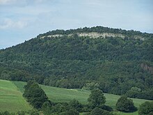
The Kleine Hörselberg, Herrenberg and Großer Hörselberg have shell limestone up to 75 m high - steep steps to the south to the Hörsel and gently sloping hilly landscapes to the north to the Nesse .
geology
The Hörselberge are made of shell limestone and red sandstone .
plants
The flora of the Hörselberge includes (sorted alphabetically):
history
The Hörselberge were already known in prehistoric times and were considered to be the home of the gods. The Frau Holle cult, documented here by several folk legends, is associated with the Hörselloch. The geographer and polymath Johann Gottfried Gregorii (Melissantes) published a description of the Hörselberge and their legends in his mountain lexicon at the beginning of the 18th century in German-speaking countries. Its legends based on site inspection were well known a century later, along with Achim von Arnim and his friend Wilhelm Grimm , just like other romantic writers, when they wrote down their texts for the Hörselberg sagas.
The Hörselberge are also identified with the Venusberg of the Tannhauser legend. Richard Wagner was inspired by the Venus Grotto for his opera Tannhäuser and the Singers' War on Wartburg .
The legend of the knight Waltmann von Sättelstätt can be traced back to a real event . A noble family residing in Sättelstädt carried the official title of Waldmann (from Sättelstädt). In the 19th century, the collector of legends Ludwig Bechstein collected a large number of local legends based on the example of the Brothers Grimm.
Since the 16th century, the border between the duchies of Saxony-Gotha and Saxony-Eisenach ran over the ridge of the ridge, and groups of old boundary stones can be found several times along the hiking trail. During this time the places Melborn , Sättelstädt , Hastrungsfeld , Kälberfeld , Schönau an der Hörsel , Ettenhausen an der Nesse and Burla also belonged to Gotha offices. The farms in Burbach were an exclave of the Kirchberg rule of Farnroda .
The Hörselberge played an important role in the life of the surrounding villages. Medicinal herbs to alleviate and prevent diseases were found on the so-called Apothekenwiese . The plateau, which was almost forest-free until the 1920s, was sought out by shepherds and shepherds, agriculture was carried out on the northern slope up to the high elevations (slope terraces on the Kleiner Hörselberg), orchards and even vineyards near Wutha and Sättelstädt are evidenced by field names. The lack of springs probably prevented permanent settlement on the plateau. Limestone was valued as a solid building material, and there were local quarries around the mountain. In Wutha there had been a commercial lime works near the train station since the 19th century.
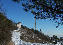
In the 19th century, the mountain became a popular excursion destination, also due to the legends and stories of the Venus cave. In 1880, the Thuringian Forest Association suggested the construction of a club house on the Großer Hörselberg, which was also to be used as an inn and refuge. After overcoming organizational and financial hardships, a log cabin was built on the summit in 1887, which was hardly able to cater for the groups of visitors who came to visit on weekends and holidays. The sponsors involved now agreed to the construction of the massive Hörselberg refuge , which was opened on July 6, 1890. After 1915 an extension was added on the north side and a separate log cabin for 100 visitors and several tank cisterns. The Hörselberg business was a profitable business until the 1930s.
In the idyllic landscape of the Kleiner Hörselberg, the Elisabethenhöhe country school home above Kahlenberg was opened, today a nursing home run by the Thuringian Diakonie.
The Tannhäuser cave was discovered around 1930 and was named by the mountain host Otto Erhardt, who hoped to attract more visitors. The construction of a cable car or tram was also considered to ease the arduous ascent. With the Olympic Games in Berlin, many foreign tourists came to the Hörselberg region, because after visiting the mountains you could easily continue your journey by train in Wutha, Schönau or Mechterstädt-Sättelstädt.
On May 29, 1930, the Hörselberge were “visited” by the Graf Zeppelin airship (LZ 127) . Coincidentally, on the same day, Thuringian glider pilots began training and first attempts to take off on the still-free summit of the Großer Hörselberg. When a 20-year-old Eisenacher crashed on the mountain over Kälberfeld on December 29, 1930 during a failed take-off, the authorities prohibited gliding on the Hörselberg.
In the years 1937 to 1940 the construction work for the construction of the Reichsautobahn took place on the southern slope of the Hörselberge. A residential camp was built in Wutha on Weinbergstrasse, and a construction warehouse with a siding was located at the Mechterstädt-Sättelstädt train station. Since grazing on the southern mountain slopes had to be stopped with the construction of the motorway, there was reforestation along the route (mainly with softwood). At the same time, forests were reforested on the north and east slopes, because agricultural cultivation was no longer profitable. One consequence of this planting action was the gradual ingrowth of popular viewpoints on the north side of the mountains.
During the Second World War there were several aerial observation points along the Hörselberge. In 1944 air battles broke out over the Großer Hörselberg in which an American plane was shot down and crashed into the rock face. Bombs were detonated several times over the sparsely populated area as emergency drops (bomb crater above the Elisabethenhöhe).
Worth seeing
The sights of the Hörselberge include:
- Hörselberghaus
- Venus cave and Tannhauser cave
- Jesusbrünnlein (service on Trinity Sunday ) above the Zapfengrund (ascent from Schönau train station)
- Hörselberg Museum Schönau
traffic
Until the beginning of 2010, a section of the federal motorway 4 ran through the Hörselberge on the southern slope , which had large climbs, four lanes and no hard shoulder no longer met today's requirements. The section has now been closed, dismantled and replaced by a new line north of the ridge, which benefits the entire flora and fauna.
Individual evidence
- ↑ a b c d e f g h Map services of the Federal Agency for Nature Conservation ( information )
- ↑ Measurement via geopaths that only contain the shell limestone hull and the strata, not the southern red sandstone slope towards the Hörsel
- ↑ a b c Height of various surveys according to non-researched source
- ^ Heinrich Weigel: Monograph of the Hörselberge Part I - The nature of the Hörselberge. In: Eisenach writings on local history. Issue 37, Eisenach 1987, 80 pp.
- ↑ Michael Köhler: Pagan sanctuaries. Jenzig-Verlag, 2007, ISBN 978-3-910141-85-8 , p. 231
- ↑ Melissantes ( Johann Gottfried Gregorii ): Curieuse OROGRAPHIA , Frankfurt, Leipzig (and Erfurt) 1715, Bavarian State Library Munich, pp. 482–498
- ^ Carsten Berndt: Melissantes. A Thuringian polyhistor and his job descriptions in the 18th century; Life and work of Johann Gottfried Gregorii (1685–1770) as a contribution to the history of geography, cartography, genealogy, psychology, pedagogy and professional studies in Germany; [a Thuringian geographer and universal scholar (1685–1770)] , Rockstuhl, 3rd edition Bad Langensalza 2015, ISBN 978-3-86777-166-5 , p. 250 f.
- ↑ Ludwig Bechstein: Sagenbuch des Hörselberg (Hör-Seelen-Berg) . (Reprint). Rockstuhl Publishing House , Bad Langensalza 2009, ISBN 978-3-86777-110-8 .
- ^ Heinrich Weigel: Monograph of the Hörselberge Part II - On the history of the Hörselberge. In: Eisenach writings on local history. Issue 38, Eisenach 1988, 104 pp.
- ^ A b Johannes Hönninger: Jubilee of a mountain house (50 years Hörselberghaus) . In: Thuringian monthly sheets . Mai-Heft, 1940, p. 4-6 .
literature
- Heinrich Weigel: Monograph of the Hörselberge Part I - The nature of the Hörselberge. In: Eisenach writings on local history. Issue 37, Eisenach 1987, 80 pp
- Heinrich Weigel: Monograph of the Hörselberge Part II - On the history of the Hörselberge. In: Eisenach writings on local history. Issue 38, Eisenach 1988 104 pp
- Herbert Kosack From Sättelstädts Past. A contribution to the chronicle of the Hörselberg community . Sättelstädt 1985
- Specially protected biotopes in the Wartburg district. In: Naturschutz im Wartburgkreis, issue 4, Eisenach 1995
- Thüringer Höhlenverein (Ed.) Leaflet on the Venushöhle - available in the Hörselberg Museum Schönau / Hörsel
- Wutha-Farnroda community (ed.): Commemorative publication for the local jubilee 650 years Wutha . Druck- und Verlagshaus Frisch, Eisenach 1999, p. 118 .
- Lutz Baumbach, Birgit Eichler, Christina Reißig et al .: Commemorative publication for the 750th anniversary of Kahlenberg . Heimatverlag Hörselberg, Wutha-Farnroda 1998, p. 94 .
- Municipal administration Kälberfeld (Ed.): Festschrift of the municipality Kälberfeld . DR advertising, Kälberfeld 1993, p. 50 .
- Festschrift of the community of Hastrungsfeld . In: Municipal administration Hastrungsfeld (ed.): Hörselbergbote . DR advertising, Kälberfeld 1993, p. 15-34 .
- Christina Reissig et al .: Commemorative publication for the local anniversary 925 years Melborn . Ed .: Melborn municipal administration. DR advertising, Melborn 2000, p. 34 .
Web links
- The geology of the Hörselberge , on hoerselberggemeinde.de
- A 4 Hörselbergtrasse , history information and photos, on eautobahn.de


