
Nesse (Hörsel)

The Nesse is a 54.5 kilometer long tributary of the Hörsel in the southern Thuringian Basin , Thuringia . Strictly speaking, it represents a second, right main arm of the Hörsel, which brings about as much water with it to unite with the Hörsel as it does itself and drains an even larger catchment area.
The Nesse is a typical flatland river with an average bed slope of only about 1.5 ‰. According to the Thuringian Water Act , it has the status of a water body of the 1st order and is therefore the maintenance burden of the Free State of Thuringia.
Emergence
The Nesse was formed at the end of the last ice age, geologists suspect that a dammed lake with melt water forced the breakthrough to the west. Neighboring rivers belong to the Elbe basin, the watershed of both rivers runs over the Alacher Höhe and Bienstädter Höhe.
course

Source area and upper course
The Nesse is created by the confluence of several drainage and spring ditches at 295 m above sea level. NN about 7 km west of Erfurt in the Alach district , not far from Erfurt Airport , and then flows in a westerly direction through the north of the Gotha district . In Nottleben your first major tributary flows into the Mollbach from the right , and further down the right tributaries of the upper reaches come from the Fahnerschen Höhe .
Lower course
At the former train station in Wangenheim , the Wilde Graben, particularly fed by the Leinakanal , flows into the Nesse from Gotha or on the left. This is where the upper course of the Nesse ends, which up to this point has been classified as 2nd class water according to Section 3 of the Thuringian Water Act. Up to the mouth, the Nesse is a first class body of water. About one kilometer west of the Wangenheim location is the Tüngeda / Wangenheim dam , which is fed by the midday water ditch from the direction of Tüngeda and drains into the Nesse about two kilometers south-east. The Wangenheimer See existed in its place until the 18th century. This is the first inflow from the Hainich . In Sonneborn , the Arzbach flows two and a half kilometers further on from the left, another four kilometers below, at Friedrichswerth , the Bieberbach flows into another Hainich tributary from the right.
Directly on the border of the district of Gotha with the Wartburg district , the body of water has been spanned by the 380 m long Nessetal viaduct of the federal motorway 4 since 2009 . On the left, the river approaches the Hörsel Mountains , from which only very short streams come. Hydrogeological studies have confirmed an underground connection with the Hörsel valley , from Ettenhausen an der Nesse to Stockhausen the Hörsel water feeds a dozen strong karst springs.
In the Wartburg district, the Nesse flows through the municipality of Hörselberg-Hainich , where the Böber flows from the right in Großenlupnitz , and reaches the area of the city of Eisenach near Stockhausen . As the last tributary, the Trenkelbach flows into the Nesse at Petersberg .
muzzle
The current confluence point of the Nesse in the Hörsel was created in the Middle Ages by building the Köpping trench. This was originally used to regulate the water level in the Hörsel. The Köppinggraben is located between the Köppingbrücke (Weimarstrasse) and Heinrichstrasse. After about 300 m the river meets a weir, here the Nessemühlgraben branches off from the Hörsel and diverts about half of the water volume into the medieval mill area on the north and west edge of Eisenach's old town. The original confluence of the Nesse can still be seen on historical maps from the 18th century: it was located west of Eichhölzchen on today's Tiefenbacher Allee. The site has been reshaped since the automobile plant was built.
Tributaries
The catchment area of the Nesse comprises with 426.3 km² 54.4% of the total catchment area of the Hörsel (784 km²) and 139.5% of the Hörsel catchment area above the Nesse estuary (305.6 km²). As a result, the Nesse brings about the same amount of water (3.14 m³ / s) to unite with the Hörsel as it does itself (3.11 m³ / s). All Nesse tributaries come from the Thuringian basin and its edge plates, while the Hörsel receiving water is largely fed from the montane Thuringian forest .
The tributaries of the Nesse are mostly typical flat-land streams with a slight gradient. Today, their courses are largely straightened and integrated into a system of drainage ditches. The stream lengths given below each roughly relate to the part that permanently carries water. Since most of the courses are canalised right up to the corresponding watershed and integrated into the drainage system, they temporarily carry water over a significantly greater length in the event of high precipitation or snowmelt, but are de facto sometimes significantly shorter than specified in dry periods.
A pipeline from the Hörsel-Oberlauf Leina - and the (upper) Apfelstädt from the Gera / Unstrut / Saale / Elbe system - to the sub-system of the Nesse is formed by the Leinakanal , which was built in the Middle Ages, around the city of Gotha with water from the Thuringian Forest to supply, and the Nesse flows over the Wilder Graben . At 104.6 km², the catchment area of the Wilder Graben is hardly smaller than that of the Nesse above (131.4 km²), plus the proportionate catchment area of Leina (TLUG Jena estimates 20.8 km²) and Apfelstädt. In purely mathematical terms, the length of the Nesse over the upper Leina, Leinakanal and Wilden Graben is 63.5 km.
| Surname |
Inflow side |
Length [km] |
Catchment area [km²] |
Mouth height [m. ü. NN] |
Place of mouth (*: at) |
DGKZ |
|---|---|---|---|---|---|---|
| Mollbach (origin in Alacher See ) | right | 7.0 | 14.0 | 285 | Emergency life | 4168-1? |
| Always (with dam Friemar ) | right | 3.8 | 281 | Friemar | 4168-1? | |
| Neußenbach | right | 4.3 | 7.6 | 278 | Oberh. Molschleben | 4168-1? |
| Attichbach | right | 3.7 | 276 | under Molschleben | 4168-1? | |
| Eschenberger Bach | right | 3.5 | 275 | 4168-1? | ||
| Wingferborn | right | 5.7 | 274 | Eschenbergen * | 4168-1? | |
| Laugh pit | Left | 3.0 | 272 | Oberh. Bufleben - Pfullendorfs | 4168-1? | |
| Herb measure pit | right | 2.7 | 258 | Wangenheim * | 4168-1? | |
| Wilder Graben (inc. Leinakanal ) | Left | 17.1 | 104.6 | 258 | Goldbach * | 4168-2 |
| Midday water (with Tüngeda dam ) | right | 11.5 | 28.2 | 257 | Oberh. Sonneborn - Eberstädts | 4168-3? |
| Arzbach | Left | 3.5 | 14.8 | 256 | Sonneborn | 4168-4 |
| Gliemen | Left | 4.1 | 255 | 4168-5? | ||
| Bruheimer Bach | right | 2.9 | 254 | 4168-5? | ||
| Bieberbach | right | 8.6 | 47.5 | 252 | Friedrichswerth | 4168-6 |
| Matergraben | right | 2.3 | 234 | Wenigenlupnitz | 4168-7? | |
| Bober | right | 8.9 | 29.5 | 228 | Grossenlupnitz | 4168-8 |
| Holzbach | right | 1.9 | 225 | Eisenach - Stockhausen | 4168-9? |
Ecology and energy production
Especially in the 1980s, the Nesse was affected by heavy pollution from the confluence of the Wilder Graben. Inadequately treated wastewater from the catchment area of the Gotha sewage treatment plant was fed into the river via the Wilden Graben. With the establishment of a state-of-the-art sewage treatment plant in Gotha by 1993, the water quality could be improved significantly.
Active hydropower plants are located on the Nesse in the districts of Ettenhausen, Wenigenlupnitz and Großenlupnitz of the municipality of Hörselberg-Hainich and in Eisenach.
Oddities
The municipality of Nesse-Apfelstädt is also named after the Nesse, although the Nesse only flows in the area of the municipal boundaries between Gamstädt and Ermstedt and thus past the municipality border with the state capital Erfurt. The district boundary runs in parts in the middle of the river.
Landscape impressions

The Nessetal near Haina
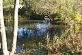
Hidden mouth of the Nesse (from left behind) in Eisenach into the Hörsel (from right)


Gallery mills

The folding mill near Ettenhausen / Nesse
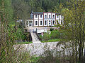
The former hydroelectric power station near Stockhausen

The Nessemühle in Eisenach


literature
- Thuringian State Agency for the Environment: The Nesse - Development of a body of water , Jena 1993
Individual evidence
- ↑ a b c Map services of the Federal Agency for Nature Conservation ( information )
- ↑ a b c River lengths according to geopaths (kmz, 150 kB)
- ↑ The directory of river lengths in Thuringia of the State Institute for Environment and Geology gives a value of 56.2 km.
- ↑ a b c d Thuringian State Agency for the Environment (ed.): Area and water code index and map. Jena 1998; 26 pp.
- ^ Deutsches Gewässerkundliches Jahrbuch Weser-Ems 2014. Lower Saxony State Office for Water Management, Coastal Protection and Nature Conservation, p. 120, accessed on October 4, 2017 (PDF, German, 8805 kB).
- ^ Möller, Wolfgang (2004): The Nesse. Part 1 - From the headwaters to the Wilder Graben. In: Hörselbergbote, H. 56, pp. 26–31.
- ↑ a b Longitudinal section of the Nesse ( page no longer available , search in web archives ) Info: The link was automatically marked as defective. Please check the link according to the instructions and then remove this notice. (TLUG Jena) - PDF, 59 kB
- ↑ For better sortability, hyphens have been inserted behind the 4168 (= Nesse).
- ↑ Length over Ratsrinne / Flutgraben - 47.7 km long over the upper Leina and Leinakanal!
- ^ Thuringian State Institute for the Environment: The Nesse - Development of a Water , Jena 1993
Web links
- Map of the rivers of Thuringia - PDF, 1.23 MB
- Map / aerial photo of the Hörsel river system