Horhausen (Westerwald)
| coat of arms | Germany map | |
|---|---|---|

|
Coordinates: 50 ° 35 ' N , 7 ° 32' E |
|
| Basic data | ||
| State : | Rhineland-Palatinate | |
| County : | Altenkirchen (Westerwald) | |
| Association municipality : | Altenkirchen-Flammersfeld | |
| Height : | 330 m above sea level NHN | |
| Area : | 4.72 km 2 | |
| Residents: | 2026 (Dec. 31, 2019) | |
| Population density : | 429 inhabitants per km 2 | |
| Postal code : | 56593 | |
| Area code : | 02687 | |
| License plate : | AK | |
| Community key : | 07 1 32 055 | |
| Community structure: | 3 districts | |
| Association administration address: | Rathausstrasse 13 57610 Altenkirchen (Westerwald) |
|
| Website : | ||
| Local Mayor : | Thomas Schmidt ( CDU ) | |
| Location of the local community Horhausen (Westerwald) in the district of Altenkirchen (Westerwald) | ||
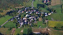
Horhausen (Westerwald) is a municipality in the Altenkirchen (Westerwald) district in Rhineland-Palatinate . It belongs to the community of Altenkirchen-Flammersfeld . According to state planning, Horhausen is designated as a basic center. The Horhausen catchment area includes around 5000 residents.
Geographical location
Horhausen im Westerwald is located on federal highway 256 in the middle between the district towns of Neuwied and Altenkirchen . The town is about three kilometers away from the A3 (Neuwied exit). Horhausen is about 350 m above sea level. NHN and is surrounded by extensive forests.
In addition to the eponymous capital, Horhausen also includes the districts of Huf and Luchert and the Horhausermühle residential area .
history
Horhausen is first mentioned on March 12, 1217 in a document from Archbishop Theoderich von Wied in Trier , in which he confirms income in Horhusin to the canons of St. Florin in Koblenz .
In 1330 the church in Hoirhusen was assessed for tax. In an interest register in favor of Herford Abbey from 1397, the localities belonging to the catchment area of the Vogtei Horhausen ( Horhusen ) are listed: Bürdenbach ( Burtillinbach ), Daufenbach ( Dufenbach ; today district of Dürrholz ), Güllesheim ( Goilshain ), Hof Bruch ( Broiche curtis ; today district of Bürdenbach), Luchert ( Luchenrode ; today district of Horhausen), Nieder- and Obersteinebach ( Steyenenbach ), Pleckhausen ( Bleckhusen ) and Willroth ( Wilrode ). Between 1338 and 1664 the Vogtei Horhausen was a fiefdom of the Counts of Isenburg and after the death of the last Count, Ernst von Isenburg-Grenzau , it fell back into electoral possession. Since then, Horhausen has belonged to the Electorate of Trier Herschbach . A process for the power of rule that Count zu Wied led as a relative of the Isenburg family before the Imperial Court of Justice petered out.
In 1684 there were nine fireplaces in Horhausen, which is likely to have corresponded to around 45 to 50 residents. By 1787, 148 people were already living in Horhausen.
The secularization of 1803 as a result of the Reichsdeputationshauptschluss led to the right of the Rhine Electoral Trier areas to the Principality of Nassau-Weilburg and then to Prussia due to the Congress of Vienna in 1815 . From 1816 it belonged to the Lower Rhine Province and there to the Flammersfeld mayor in the Altenkirchen district.
Around 1835 Horhausen received a new school building with two classrooms for 250 children, which was already in disrepair a decade later. A new building failed due to the lack of financial resources. It was not until 1866 that the government in Koblenz gave permission to build a two-class school, although space for four classes would have been required.
- Population development
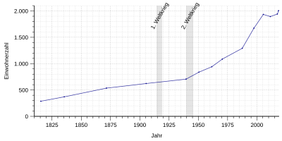
The development of the population of Horhausen (Westerwald); the values from 1871 to 1987 are based on censuses:
|
|
politics
Municipal council
The local council in Horhausen (Westerwald) consists of 16 council members, who were elected in the local elections on May 26, 2019 , and the honorary local mayor as chairman.
The distribution of seats in the municipal council:
| choice | SPD | CDU | Flat share | total |
|---|---|---|---|---|
| 2019 | 4th | 9 | 3 | 16 seats |
| 2014 | 4th | 10 | 2 | 16 seats |
| 2009 | 4th | 9 | 3 | 16 seats |
| 2004 | 3 | 10 | 3 | 16 seats |
mayor
Thomas Schmidt became local mayor of Horhausen on January 1, 2013. In the direct election on May 26, 2019, he was confirmed in his office for another five years with a share of the vote of 73.97%. Thomas Schmidt's predecessor was Rolf Schmidt-Markoski, who had resigned from office after 13 years for professional reasons on December 31, 2012.
Culture and sights
Buildings
Horhausen's landmark is the parish church of St. Maria Magdalena with the tower that can be seen from afar. The church, also known as the Westerwald Cathedral , was built in 1902 in neo-late Romanesque forms according to plans by government architect Heinrich Krings , Cologne. The Romanesque tower was increased by one storey and included in the new building.
In Horhausen, the birthplace of Cardinal Joseph Höffner , a memorial in honor of the cleric was unveiled on May 8, 2005. After a year the artist removed the head because the city couldn't / didn't want to pay for it in full. The head was then covered until it was found by the artist and welded on again. Cardinal Joseph Höffner is now wearing a "ruff".
Cultural monuments
See list of cultural monuments in Horhausen (Westerwald)
Regular events
The community itself, but also many associations, offer numerous festivals and events.
- On Easter Sunday, young and old can take part in the traditional Easter egg throwing competition.
- On the Saturday before Mother's Day, the famous flower market takes place, which is one of the largest flower markets in Rhineland-Palatinate.
- At the end of July, the Magdalenen fair is celebrated in Horhausen, the kite flying day takes place in autumn, and the October market closes the community's event year.
- At the beginning of November, MGV Horhausen and its three choir formations organize the large choir concert with over 120 active singers.
Born in Horhausen
- Joseph Cardinal Höffner (1906–1987), Cardinal, Archbishop of Cologne, Chairman of the German Bishops' Conference (1976–1987)
- Friedrich Dasbach (1846–1907), Catholic priest, publicist and social reformer
- Johannes Rüth (1899–1978), Bishop of Trondheim
- Rolf Schult (1927–2013), actor and German dubbing voice for Robert Redford, Anthony Hopkins and others
- Georg Stenz (1869–1928), Steyler missionary in China, educator a. Head of the Franz-Xaver College in Jinin, Shandong, China
Web links
- Internet presence of the local community Horhausen
- Local community Horhausen on the website of the community community Altenkirchen-Flammersfeld
- Detailed history of Horhausen
- Short portrait with a film about Horhausen bei Hierzuland , SWR television
Individual evidence
- ↑ State Statistical Office of Rhineland-Palatinate - population status 2019, districts, communities, association communities ( help on this ).
- ↑ a b State Statistical Office Rhineland-Palatinate - regional data
- ↑ State Statistical Office Rhineland-Palatinate (ed.): Official directory of the municipalities and parts of the municipality. Status: January 2018 [ Version 2020 is available. ] . S. 9 (PDF; 2.2 MB).
- ↑ Philipp de Lorenzi: Contributions to the history of all parishes in the Diocese of Trier , Volume 2, Bischöfliches General-Vicariate, Trier 1887, p. 533f ( online edition )
- ^ The Regional Returning Officer Rhineland-Palatinate: Local council election 2019 Horhausen. Retrieved January 4, 2020 .
- ^ The Regional Returning Officer Rhineland-Palatinate: Municipal elections 2014, city and municipal council elections
- ^ The Regional Returning Officer Rhineland-Palatinate: direct elections 2019. see Altenkirchen-Flammersfeld, Verbandsgemeinde, 27th line of results. Retrieved January 4, 2020 .
- ^ AK-Kurier: CDU nominated Thomas Schmidt for mayoral election. July 15, 2012, accessed January 4, 2020 .
- ↑ http://www.ak-kurier.de/akkurier/www/artikel/10271---kopfloser-kardinal---ist-wieder-vollstaendig-in-horhausen


