
Juergeshof
|
Juergeshof
City of Rostock
|
|
|---|---|
 |
|
| Area : | 3.2 km² |
| Residents : | 19 (Dec. 31, 2017) |
| Population density : | 6 inhabitants / km² |
| Incorporation : | September 10, 1978 |
| Area code : | 0381 |
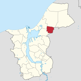  Location of Jürgeshof in Rostock
|
|
Jürgeshof is a district of the city of Rostock in Mecklenburg-Western Pomerania . Among the 31 districts of the city, Jürgeshof is the last to be incorporated (as of 2017) and with 17 inhabitants the second smallest after Peez .
location

Jürgeshof is located in the northeast of the Rostock urban area, about 15 kilometers from Rostock city center on the "Bäderstraße" from Rostock- Dierkow to Hinrichshagen and on to Graal-Müritz . The extensive forest areas of the Rostock Heath begin north of the residential development . In the south and west, Jürgeshof borders on the Rostock district of Stuthof and in the north on Hinrichshagen, also a district of Rostock. In the east lies the municipality of Rövershagen , in the southeast that of Mönchhagen .
Jürgeshof consists of a few houses on the street; in addition, allotments are attached to the edge of the forest.
history
According to texts from the 19th century, Jürgeshof belonged to the Rostock Hospital of the Holy Spirit , just like the neighboring Purkshof (today part of Rövershagen ) . The two places were previously called Jörshagen and Purkshagen. The place is mentioned as early as the 17th century, the name is derived from the first name Jürgen.
Around 1860, Jürgeshof and Purkshof were leased by the von Haefften family. The tenant moved the farm from the middle of the field to the current location of the place on the edge of the forest. The earlier location is described around 1850 as "on a brook falling into the Breitling ". At that time, Jürgeshof had 26 residents. Ecclesiastically, Jürgeshof belonged to the parish of the church in Rövershagen .
Until 1922, Jürgeshof formed a rural community together with Stuthof, Schnatermann and Purkshof. Then it came to the municipality of Mittel-Rövershagen (at that time the name for the central part of Rövershagen). In 1930 the place is mentioned as a leasehold with 17 inhabitants.
In 1978 the Jürgeshof, which last belonged to the Mönchhagen community, was incorporated into Rostock.
traffic
Jürgeshof is connected to the Baltic Sea via Landesstrasse 22 from Rostock-Dierkow. The stop in town is served by the Rostock bus line 18 about every one to two hours.
Individual evidence
- ↑ Statistics office of the city of Rostock: Population with main residence of the Hanseatic and university city of Rostock by district - as of December 31, 2017
- ^ A b Archive for regional studies in the Grossherzogthümen Mecklenburg , eighteenth year, Verlag der Hofbuchdruckerei von AW Sandmeyer, Schwerin 1868, p. 250, online at Google Books.
- ^ Fritz Haeger, The German place names of Mecklenburg since the beginning of colonization , Eberhardtsche Hof- und Ratsbuchdruckerei, Wismar 1935, p. 69.
- ↑ Gustav Hempel , Topographical-historical description of the Meklenburger country. Second, increased edition of the second part of Hempel's geographical-statistical-historical handbook. , Printing and publishing of the Hinstorffschen Hofbuchhandlung , Wismar and Schwerin 1852, p. 70.
- ^ Government Gazette for Mecklenburg-Schwerin , year 1922, p. 315.
- ^ Keyword Jürgeshof, in: Mecklenburgisches Ortverzeichnis 1930, Cities and Towns of the States Mecklenburg-Schwerin and Mecklenburg Strelitz , Verlag Boldt, 1930.
Biestow | Brinckmansdorf | Diedrichshagen | Dierkow-Neu | Dierkow-Ost | Dierkow-West | Evershagen | Garden city / city pasture | Gehlsdorf | Big small | Hansaviertel | Hinrichsdorf | Hinrichshagen | High dune | Jürgeshof | Kröpeliner-Tor-Vorstadt | Krummendorf | Lichtenhagen | Lütten Klein | Markgrafenheide | Nienhagen | Peez | Reutershagen | Schmarl | City center | Stuthof | Südstadt | Toitenwinkel | Peat bridge | Warnemünde | Wiethagen .