
Kīlauea
| Kīlauea | ||
|---|---|---|
 Location of the Kīlauea, schematic overview with caldera and rift zones |
||
| height | 1247 m | |
| location | Big Island | |
| Mountains | Hawaii | |
| Coordinates | 19 ° 25 ′ 16 ″ N , 155 ° 17 ′ 12 ″ W | |
|
||
| Type | Shield volcano | |
| rock | basalt | |
| Last eruption | 1983-2018 | |
| particularities | One of the most active volcanoes on earth | |

The Kīlauea ( German Kilauea ) is an active shield volcano on to Hawaii belonging island Big Iceland . In the Hawaiian language , kīlauea means “spit” or “spread a lot”. Embedded in the currently solidified caldera of Kīlauea is the Halemaʻumaʻu crater, in the bottom of which there was an active lava lake until May 2018 .
geography


The Kīlauea is part of a chain of volcanoes, the Hawaii-Emperor-Chain , which extends from the northwest Pacific to Hawaii. While the ocean floor moved over a locally fixed hot spot in the Earth's mantle , it created this long chain of islands over millions of years, of which only a few islands can be seen on the surface today. The northernmost is Midway Island .
In addition to the Kīlauea, there are two other active volcanoes on the Big Island, the Mauna Loa and the Hualālai, and two presumably inactive volcanoes, the Mauna Kea and the Kohala .
Volcanic activity
The Kīlauea is currently one of the most active volcanoes on earth. As with most volcanoes that lie above hotspots , the eruptions are effusive : Lava gushes upwards from the earth's interior and flows off in continuous lava flows. Although the vast majority of the eruptions are therefore not explosive, there are exceptions. For example, from May 11 to May 27, 1924, a series of powerful explosions occurred in the Halemaʻumaʻu crater, in which rocks weighing several tons were thrown several kilometers out of the crater. This was caused at that time by large amounts of inflowing groundwater , which suddenly evaporated when it came into contact with magma . The rock above was blown away by the steam pressure.
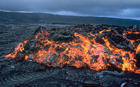
The majority of the eruptions are more peaceful, however, as the lava of Hawaiian volcanoes has a very low viscosity . In the thin liquid lava, trapped gases can escape more easily before an eruption and do not build up high pressure, in contrast to the eruption of Mount St. Helens in 1980 . The viscosity of lava is influenced by several factors: its temperature, its chemical composition and its gas content.
The most recent eruption of Kīlauea lasted from January 3, 1983 to 2018. Most of it did not take place in the main crater, but mainly in the Puʻu- ʻuʻō -crater about 15 km away . The lava flows from there sometimes flowed into the Pacific, where the lava, which is over 1100 degrees Celsius, is suddenly cooled by the sea water. The lava does not flow above ground all the way, but often in lava tubes .
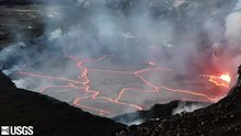
In the three to four kilometer long caldera of the Kīlauea lies the shaft crater of Halemaʻumaʻu , in the bottom of which an active lava lake about 200 meters in size was sunk between 60 and 150 meters deep from 2008 to 2018 .
From May 3, 2018 (local time) , crevices formed in the eastern rift valley, 40 km east of the Kīlauea caldera, in the Puna district in a populated forest area, the so-called Leilani Estates and later also Lanipuna Gardens, from which lava oozed. These fissure eruptions were accompanied by earthquakes, the strongest of which reached magnitude 6.9 - the most violent tremor in Hawaii since 1975 (7.1), when 2 people died. On May 3, 1700 people were officially ordered to leave the area. Another 10,000 residents of the Puna district were advised to leave as a precaution. In addition, the state of emergency was declared . On May 11, 2018, the Hawaii Volcanoes National Park was closed. In connection with the earthquakes and the penetration of magma in the fracture zone, the Hawaiian Volcano Observatory published some facts according to which a feared catastrophic demolition along the Hilina Rift would be extremely unlikely. After several weeks of volcanic activity, partly after explosions, a large ash cloud formed over Halemaʻumaʻu on May 15 and 17, 2018. After hotter magma from the Puʻu ʻŌʻō had reached the fissures, lava flows formed, flowing towards the southeast, reaching the ocean on May 19, 2018 after crossing the coastal road Hawaii State Route 137 between Pohoiki and Opihikao. After the main activity was shifted to column no. 8, on June 2, 2018, another lava flow, initially flowing to the northeast, reached Hawaii State Route 137 again at the intersection of "Four Corners" in the village of Kapoho, which was destroyed by a lava flow in 1960 and then relocated and first cut them off and then buried them almost completely until the lava flow reached the ocean on June 4th. The lava masses also filled Green Lake , the largest freshwater lake on the island, causing the water to evaporate. During the eruption there was an increasing seismic activity in the main crater, which led to an almost daily collapse of the crater floor and the edges of the Halemaʻumaʻu. The lava flow from column no. 8 corresponded to this. Activity declined in early August: the last sagging of the bottom of the main crater was recorded on August 2, 2018, seismic activity there declined on August 4, and the lava channel from column 8 near it was declared empty on August 6.

Sulfur deposits on the edge of Halemaʻumaʻu

Cooled lava flow buries a road under it
ʻAʻa Lava at Kīlauea

Ash cloud over Halemaʻumaʻu on May 15, 2018

Ocean ingress and forest fires


tourism
The Kīlauea with its side craters is part of the Hawaiʻi Volcanoes National Park on the Big Island and is one of the most frequently visited active volcanoes by tourists.
mythology
In the Hawaiian religion , the Halemaʻumaʻu crater in the caldera of Kīlauea is considered the seat of the volcano goddess Pele .
See also
Web links
Photos and videos
- http://www.swisseduc.ch/stromboli/perm/hawaii/index-de.html
- Volcano World: Kīlauea ( Memento from January 30, 2014 in the Internet Archive )
- Selected images of the Puʻu ʻŌʻō-Kūpaianaha eruption ( US Geological Survey )
Geological map material
Scientific contributions
- Kīlauea in the Global Volcanism Program of the Smithsonian Institution (English)
- Hawaiian Volcano Observatory: Kīlauea - Perhaps the World's Most Active Volcano , USGS (English)
- Ken Hon, ea: Field interpretation of active volcanoes. A handbook for viewing lava , Geology Dept., University of Hilo, Hawaii, 2008 (PDF, English; 8.3 MB)
- J. Almendors, ea: Identifying elements of the plumbing system beneath Kilauea Volcano, Hawaii, from the source locations of very-long-period signals , Geophysical Journal International, Vol. 148, iss. 2, pp. 303-312, Feb. 2002; doi : 10.1046 / j.1365-246X.2002.01629.x (Wiley, abstract, English)
- HC Hardee, ea: Probing the melt zone of Kilauea Iki Lava Lake, Kilauea Volcano, Hawaii , GEOPHYSICAL RESEARCH LETTERS, VOL. 8, NO. 12, P. 1211, 1981; doi : 10.1029 / GL008i012p01211 (Abstract, English)
- Brooks, ea: Magmatically triggered slow-slip at Kilauea volcano, Hawaii , Brevia, Science, Vol. 321, 2008 (PDF, English; 206 kB)
Travel reports
- A visit to the crater of the great Kirauea volcano by Charles Stewart, in 1825, from Wikisource: "The Abroad (1828)"
Individual evidence
- ↑ Kīlauea in Place Names of Hawaiʻi
- ↑ a b The lava lake is visible early in the video, with overflows onto the caldera floor on April 23, but the lake vanishes from sight in early May as pressure in the summit magma reservoir decreases. Photo & Video Chronology: July 12, 2018, Kīlauea summit activity ( Memento from July 13, 2018 in the Internet Archive )
- ↑ HVO, webcams ; accessed on February 2, 2017
- ↑ Summary of Historical Eruptions, 1750 - Present
- ↑ Image of a lava fountain ( Memento from October 4, 2013 in the Internet Archive )
- ^ The 1924 explosions of Kilauea
- ↑ USGS, Hawaiian Volcano Observatory: Kīlauea - Perhaps the World's Most Active Volcano (English); 7 months of no lava at Puʻu ʻŌʻō heralds end of an era (US Geological Survey Hawaiian Volcano Observatory, January 31, 2019); Preliminary summary of Kīlauea Volcano's 2018 lower East Rift Zone eruption and summit collapse (USGS)
- ↑ cf. the information in Volcano World (Oregon State University) for basaltic lava and the US Geological Service (FAQs on the volcanoes in Hawaii) ( Memento of the original from February 3, 2017 in the Internet Archive ) Info: The archive link was automatically inserted and not yet checked . Please check the original and archive link according to the instructions and then remove this notice. with slightly higher values; The information of approx. 2000 ° C , which frequently appears in various media, is probably based on an incorrect transfer of the 1100 ° C corresponding temperature of 2012 degrees Fahrenheit.
- ↑ Hawaiian Volcano Observatory: Recent Kilauea Status Reports, Updates, and Information Releases, HAWAIIAN VOLCANO OBSERVATORY DAILY UPDATE, Saturday, September 29, 2012 7:46 AM HST (Saturday, September 29, 2012 5:46 PM UTC). ( Memento from October 6, 2012 in the Internet Archive )
-
↑ Leilani Estates; see. also Leilani Estates with further references

- ↑ Strongest vibration since 1975. orf.at, May 5, 2018, accessed May 5, 2018.
- ↑ Kilauea Volcano Erupts. USGS website, May 4, 2018 ff., Accessed May 6, 2018
- ↑ Hilina Slump , cf. Roger P. Denlinger, Julia K. Morgan: Characteristics of Hawaiian volcanoes (= Professional Paper 1801; https://pubs.usgs.gov/pp/1801/ ). US Geological Survey, 2014, ISSN 2330-7102 , Chapter 4: Instability of Hawaiian Volcanoes ( usgs.gov [PDF]).
- ↑ Hawaiian Volcano Observatory Status Report (US Geological Survey) ( Memento from May 19, 2018 in the Internet Archive ); Ash rain on Hawaii Spiegel Online, May 17, 2018
- ↑ a b 'Laze' plume could carry toxic substances miles away from lava's ocean entry . 20th May 2018.
- ↑ various maps of the USGS
- ↑ PDF: Volcanic Hazard at the Summit of Kīlauea: June 29, 2018 Update
- ↑ Changes in the caldera of Kīlauea from May 14 to July 19, 2018 ( Planet Labs Inc.)
- ↑ From the archived status reports from August 4th to 8th, 2018
- ^ WD Westervelt: Hawaiian Legends of Volcanoes , p. 174