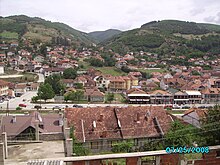
Kaçanik
|
Kaçanik / Kaçaniku 1 Kačanik / Качаник 2 |
||||
|
||||
| Basic data | ||||
|---|---|---|---|---|
| State : |
|
|||
| District : | Ferizaj | |||
| Municipality : | Kaçanik | |||
| Coordinates : | 42 ° 14 ' N , 21 ° 16' E | |||
| Residents : | 10,393 (2011) | |||
| Telephone code : | +383 (0) 29 | |||
| Postal code : | 71000 | |||
| License plate : | 05 | |||
|
1 Albanian (indefinite / definite form) , 2 Serbian (Latin / Cyrillic spelling) 3 Kosovo's independence is controversial. Serbia continues to regard the country as a Serbian province. |
||||
Kaçanik ( Albanian also Kaçaniku , Serbian Качаник Kačanik ) is a city in southeastern Kosovo and the headquarters of the associated municipality .
geography
Kaçanik is located in the southern part of Kosovo on the Lepenac River and borders in the north on Ferizaj , in the northeast on Vitia , in the west on Štrpce and in the south on Han i Elezit , which used to be part of the municipality of Kaçanik. The length of the border with the Republic of Macedonia is 11.42 km.
Limiting lengths of the neighboring communities
| Communities | Length in km |
|---|---|
| Ferizaj | 20.05 |
| Vitia | 27.10 |
| Macedonia (Southeast) | 6.62 |
| Han i Elezit | 23.34 |
| Macedonia (Southwest) | 11.42 |
| Štrpce | 12.88 |
| total | 101.41 |
history
The first evidence of the existence of early settlements was found in the 1980s, when a grave with an inscription from the 2nd century was found while a shopping mall was being built. The find is now in the city's cultural center.
Koxha Sinan Pasha is considered the founder of today's city in the 16th century. Koxha Sinan Pasha built a mosque that still exists today; a school; two inns; a hammam ; a castle and several mills on the Lepenc river . Until 1891, the city was part of the Sandschak Skopje , in Vilayet Kosovo .
population
In 2011 the village of Kaçanik counted 10,393 inhabitants in the census. Of these, 10,369 (99.77%) were Albanians , 10 Bosniaks and 5 Roma , 1 Serb and 1 Turkish and 4 indicated a different ethnicity.
| Census | 1948 | 1953 | 1961 | 1971 | 1981 | 1991 | 2011 |
|---|---|---|---|---|---|---|---|
| Residents | 2094 | 2275 | 2923 | 4513 | 6629 | 9800 | 10,393 |
traffic
Kaçanik is located 50 kilometers southeast of the capital Pristina on its road connection to Skopje . The city also has a train station on the north-south main connection of the Trainkos from Fushë Kosova to Thessaloniki (built in 1879). Two passenger trains in each direction run between Fushë Kosova and Hani e Elezit every day.
The Autostrada R 6 connects the capital Pristina with the Macedonian capital Skopje, which runs through Kaçanik. The total length of the route is 60 kilometers.
Personalities
- Berat Luzha (* 1953), politician ( PDK )
- Lutfi Zharku (* 1962), politician ( LDK )
- Avni Tafili (* 1978), theologian and writer
- Ag Apolloni (* 1982), writer and university lecturer
- Lavdrim Muhaxheri (1989-2017), Islamist terrorist
- Ismail Morina (* 1990), football player
Web links
Individual evidence
- ↑ Ethnic composition of Kosovo 2011. In: pop-stat.mashke.org. Retrieved January 10, 2018 .
- ↑ Kosovo censuses. In: pop-stat.mashke.org. Retrieved July 24, 2018 .
- ↑ Orari i trenave | TRAINKOS. Retrieved August 21, 2018 (sq-AL).
- ↑ Hapet segmenti i ri i Autostradës “Arbër Xhaferi”. In: ALSAT-M. December 31, 2016, accessed January 2, 2016 (Albanian).


