
Cape Chelyuskin
Coordinates: 77 ° 43 ′ 21.7 " N , 104 ° 15 ′ 12.8" E


The Cape Chelyuskin ( Russian Мыс Челюскин ) is the northernmost point of the Taimyr Peninsula and thus the northernmost mainland imagine the earth . It is named after the Russian polar explorer Semyon Ivanovich Tscheljuskin .
Geographical location and history
The cape is located, as part of the very sparsely populated only a few streams Tundra , about 1300 km beyond the northern polar circle , and passes the flat there Siberian land mass over the Vilkitsky Strait to the island group Severnaya Semlja out over which up to 81 ° north latitude protrudes (length 90 ° to 106 ° East). The Byrranga Mountains run south of the cape and reach a height of 1125 m northeast of Lake Taimyr .
The Chelyuskin Cape was discovered by Russian seal hunters and traders in the early 17th century . Other difficult coastal passages were not explored until 1733/34 during Vitus Bering's Second Kamchatka Expedition. The cape represents the turning point of the Northeast Passage - the ice-free sea route that has been sought for centuries from the northern coasts of Europe to the Bering Strait . On this middle section of the 6,500 km long route, which Adolf Erik Nordenskiöld managed to complete in the summers of 1878 and 1879, the most varied of flow conditions through the great rivers of Siberia ( Ob , Yenisei and Lena ) meet. Therefore, the ice conditions used to be difficult to predict. These sea routes have been systematically expanded since the 20th century and kept free by heavy icebreakers during the transition period .
Climate table
The climate, winds and ocean currents are shaped by the nearby Arctic Ocean (14.09 million km²). The winters are long and extremely cold with a January mean of −31.1 ° C, the summers are short, cool, often foggy and with a July mean of 0.8 ° C, very cold. Every year around 244 mm of precipitation falls on average .
| Cape Chelyuskin | ||||||||||||||||||||||||||||||||||||||||||||||||
|---|---|---|---|---|---|---|---|---|---|---|---|---|---|---|---|---|---|---|---|---|---|---|---|---|---|---|---|---|---|---|---|---|---|---|---|---|---|---|---|---|---|---|---|---|---|---|---|---|
| Climate diagram | ||||||||||||||||||||||||||||||||||||||||||||||||
| ||||||||||||||||||||||||||||||||||||||||||||||||
|
Average monthly temperatures and rainfall for Cape Chelyuskin
Source: wetterkontor.de
|
|||||||||||||||||||||||||||||||||||||||||||||||||||||||||||||||||||||||||||||||||||||||||||||||||||||||||||||||||||||||||||||||||||||||||||||||||||||||||||||||||||||
Photo gallery

Cape Chelyuskin, ...
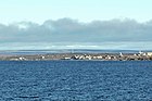
... northernmost mainland point ...

… the earth …

... and Asia ...

... with polar station


See also
Individual evidence
- ↑ a b c Geoklima 2.1 , on hanisch.de