Kienersrüti
| Kienersrüti | ||
|---|---|---|
| State : |
|
|
| Canton : |
|
|
| Administrative district : | Tuna | |
| Residential municipality : | Uttigen | |
| Postal code : | 3628 | |
| Coordinates : | 609 350 / 182903 | |
| Height : | 579 m above sea level M. | |
| Area : | 0.8 km² | |
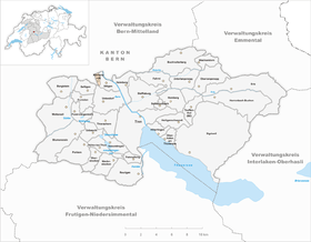
| map | ||
|
|
||
Until December 31, 2013, Kienersrüti was a political municipality in the Thun administrative district in the canton of Bern in Switzerland . Kienersrüti merged with the municipality of Uttigen on January 1, 2014 .
geography
Kienersrüti is 579 m above sea level. M. , seven kilometers northwest of the city of Thun (as the crow flies). The farming village extends on a ridge of the southern foothills of the Belpberg , between the Limpachtälchen in the west and the Aareniederung in the east.
The area of the municipality, which is just 0.8 km² in size, encompasses a section of the Aare valley between Bern and Thun. The western border runs along the canalised Limpach . From here, the municipality extends eastward over the flat, formerly marshy valley basin to the ridge of Kienersrüti, which was shaped by the Ice Age Aar glacier. At 600 m above sea level M. the highest point in the community is reached in the forest of the Limpachhubel . In 1997, 5% of the municipal area was accounted for by settlements, 12% for forests and woodlands and 83% for agriculture.
Some farm groups and individual farms belong to Kienersrüti. Until December 31, 2013 , neighboring communities of Kienersrüti were Kirchdorf , Uttigen , Uetendorf and Noflen .
population
Kienersrüti is one of the smallest communities in the canton of Bern. In the 2000 census, all of the residents stated German as their mother tongue. The population of Kienersrüti was 91 in 1850, compared with 48 in 1900. In the course of the 20th century the population rose again to 79 people by 1950. Since then, a population decline of almost 40% has been recorded due to strong emigration.
economy
Kienersrüti still lives from agriculture , especially from agriculture and cattle breeding . There are no jobs in the village outside the primary sector. Some employees are commuters who work mainly in the larger towns in the area and in the Thun area.
traffic
The community is located away from the major thoroughfares, the main access is from Uttigen . The closest connection to the A 6 motorway (Bern - Thun) is around 5 km from the town center. Kienersrüti has no connection to the public transport network.
history
The place was first mentioned in a document in 1676 under the name Kienersrütte . The spellings Kieners Rütti (1739) and Kienersreuti (1838) appeared later . The place name denotes a clearing ( Old High German riod ) of the Kiener family.
The area of Kienersrüti used to belong to the domain of the Barons of Kramburg. Under the rule of Bern (since the Reformation in 1528) it was subordinate to the Seftigen district court, while the church rights (tithe) were held by the Canons of Amsoldingen. In 1742 Kienersrüti became an independent municipality. After the collapse of the Ancien Régime (1798), Kienersrüti belonged to the Seftigen district during the Helvetic Republic and from 1803 to the Seftigen District Office, which received the status of an official district with the new cantonal constitution of 1831. Today the village works closely with the neighboring community of Uttigen.
Attractions
One of the places of interest is the oven house, which was restored in 1996. Characteristic farmhouses in the Bernese style from the 18th and 19th centuries have been preserved in the courtyard groups. Kienersrüti does not have its own church; it belongs to the parish of Kirchdorf.


