
Krückau
| Krückau | ||
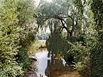
 The Krückau near Elmshorn |
||
| Data | ||
| Water code | DE : 5975 | |
| location | Germany, southwest of Schleswig-Holstein | |
| River system | Elbe | |
| Drain over | Elbe → North Sea | |
| River basin district | Elbe | |
| origin | In the south of Kaltenkirchen 53 ° 49 ′ 20 ″ N , 9 ° 58 ′ 15 ″ E |
|
| muzzle | In Seestermühe in the Pagensander Nebenelbe Coordinates: 53 ° 42 ′ 52 " N , 9 ° 30 ′ 43" E 53 ° 42 ′ 52 " N , 9 ° 30 ′ 43" E
|
|
| length | 37 km | |
| Catchment area | 275.7 km² | |
| Drain |
MQ |
2.42 m³ / s |
| Left tributaries | Eckholterau | |
| Right tributaries | Höllenbek, Offenau | |
| Medium-sized cities | Elmshorn | |
| Small towns | Kaltenkirchen , Barmstedt | |
| Communities | Seester , Seestermühe | |
| Navigable | Federal waterway from Elmshorn to the mouth (11.3 km) | |
The Krückau is a river in Schleswig-Holstein that flows into the Elbe . In terms of the type of flowing water , it is marshland (type 22).
course


It is being built in the south of Kaltenkirchen, south of the Carl-Benz-Straße industrial park, from the confluence of drainage ditches and rainwater retention basins. Before 1878 the origin of the Krückau was in the area of today's industrial area south of Kaltenkirchen, east of Hamburger Straße, which was sealed by the development.
On its way to the mouth , the Krückau flows through the two towns of Barmstedt , where it passes the Castle Island and the Rantzauer See , and Elmshorn . It is still from other small streams, u. a. the Offenau fed. In Barmstedt, it touches the aforementioned lake and flows through an artificially created fish ladder . At the mouth in Seestermühe there is a barrage which is closed when there is a risk of storm surge and protects Elmshorn and the marshland communities.
The Krückau is about 40 km long.
Federal waterway - navigability - tides
From the Elmshorn harbor to the confluence with the Elbe federal waterway, the Krückau (Kr) is in the area of responsibility of the Hamburg Waterways and Shipping Office - from the road bridge (Wedenkamp) in Elmshorn at km 0.015 to the confluence with the Pagensander Nebenelbe at km 11.319 at Elbe-km 663.46. The Krückau is one of the inland waterways on which the sea shipping route regulations apply.
Because of the heavy siltation, the river is often only navigable for small pleasure boats. It is also diked on this stretch, which, up until the construction of the barrage in 1969, led to the fact that during storm surge, the water masses from the Elbe were literally channeled into the Elmshorn city center and led to floods there, usually by a meter. Storm surge markers, small metal signs with the date and marking of the water level, can still be found on many older houses today. The water level of the Krückau depends on the tide up to Elmshorn , as the stretch of the Elbe estuary, which is influenced by the tidal range , presses the water into the estuaries.
Expansion work below Elmshorn was carried out from 1873 to around 1900. More followed in 1927–1934 with flattened curves and bank protection. To improve the estuary, the 280 meter long northern and 1952 the 200 meter long southern dam were built in 1937.
The storm surge barrier, built in 1969, has a 20-meter-wide shipping opening with mortise gates , the two side openings, each 12-meter-wide, have helicopters as locking devices.
history
The names Ciestere (1141), Zeistere (1144), Ciestre (1223), Ksestera (after 1223), later Xesterowe and Zesterowe, which translated means “Seester Aue” , can be traced for the river . Accordingly, the surrounding place names point to the river: Seester as the municipality that lies on the Seester Aue, Seestermühe as the place at the mouth of the Seester Aue ( Mühe derives from Muthe = "mouth"). The name Kröecke or Kruck for the surrounding land can be traced back to 1373. The watercourse flowing through it was accordingly called Krocker Aue . The name Kröeckau and finally Krückau did not establish itself until the 19th century. In 1657, during the First Northern War (1655 to 1660), the Krückau near Elmshorn was the scene of a battle between the Danes and Swedes, when Danish troops defended the Krückau crossing and the Kruckschanze fortress. According to a document from 1764, shipbuilding was carried out on the banks of the Krückau . Elmshorn has a port through the Krückau , from which the “Greenland trip” or whaling was operated in 1817 with the ship Flora . The name of the ship is still present in many places in Elmshorn, the ship is adorned with the town's coat of arms. During this time, a oil distillery "auf der Kruck" was built, which was operated until 1872.
Krückauhafen Elmshorn
Excursion steamers later left the port and until 2002 grain was delivered for the two grain factories located there. Today only recreational captains, water sports enthusiasts and in the warm season the traditional ship Ewer Gloria sail the Krückau. Due to the low level of use, the flow that comes to a standstill when the barrage is closed and the lack of flushing after storm surges, the river silts up very heavily in a very short time.
- Krückau in Elmshorn - upper course
The upper reaches in the Krückau Park

In the Kaltenweide residential area, the river is still tide-dependent.

The Hamburg-Kiel / Westerland railway line crosses the Krückau.


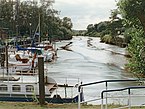
- Krückau in Elmshorn - harbor

Harbor, south bank with the Kölln works in 1999
The underflow at low tide
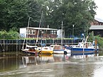
Pleasure boats in the harbor

Opening times of the barrage at the mouth of the Elbe


Kronsnest ferry

Between the municipalities of Seester (Pinneberg district) and Neuendorf (Steinburg district) runs in the summer months from May 1st to October 3rd, the " Kronsnest ferry ", a traditional ferry connection in which a small wooden boat is sculled by hand over the high tide at this point 40 meters (at low tide approx. 16 meters) wide Krückau is steered. Formerly an important link in everyday life between the communities, today it is mostly used by tourists and day trippers - in September 2006, the 100,000 passengers since the reopening in 1993 were welcomed. According to its own information, it is the smallest ferry in Germany and the only hand-operated ferry in Schleswig-Holstein.
Water quality, fish stocks, kingfisher
The Krückau was one of the most polluted rivers in Germany until the 1970s. The main cause was the industry in downtown Elmshorn. An Elmshorn describes the situation in the 1930s as follows: "With a view of the train station, wastewater from dye works in all colors flowed into the meadow on the left, on the right the outlet of the pipe from meat factories was very often blood red. Down the river [...] were the outlets from tanneries and yeast factories. It was no wonder that in certain weather conditions it stank in Elmshorn. "
The situation improved thanks to a large sewage treatment plant in Hetlingen an der Elbe , which opened in 1973 , in which other communities in the Pinneberg and Segeberg districts also have their wastewater treated.
Despite the murky water, there are carp-like fish and eels as well as brown trout and even sea trout for spawning . In addition, several populations of the rare kingfisher live on the Krückau.
literature
- Uwe Barghaan: CD-ROM Elmshorn and Klein Nordende. 2001.
- Contributions to the history of Elmshorn. In: Series on the social, economic and cultural history of Elmshorn. (Since 1987).
- Peter Danker-Carstensen, Seester municipality (ed.): History of a village in the Elbmarsch at the same time a contribution to the history of the Seester parish. , 1994.
- M. Eckoldt (ed.): Rivers and canals. The history of the German waterways. DSV-Verlag 1998.
- Muus / Petersen / König: The inland waters of Schleswig-Holstein. 1973.
- Rainer Naudiet: Stör lock, crutch lock, pin lock. Hansen & Hansen, Münsterdorf 1975, ISBN 3-87980-503-2 .
- Peter Danker-Carstensen, Stephan Richter "Hol över" the ferry Kronsnest over the Krückau. Working group inland ferries in Germany
Web links
Individual evidence
- ↑ a b Lower Elbe and its catchment area ( Memento from March 7, 2016 in the Internet Archive ) (PDF; 6.1 MB)
- ↑ a b Lengths (in km) of the main shipping routes (main routes and certain secondary routes) of the federal inland waterways ( memento from January 21, 2016 in the Internet Archive ), Federal Waterways and Shipping Administration
- ^ Mes table sheet 2125 ( Memento from May 12, 2013 in the Internet Archive ); 1: 25,000; from 1878; At: greif.uni-egoswald.de
- ↑ Directory E, serial no. 24 der Chronik ( Memento from July 22, 2016 in the Internet Archive ), Federal Waterways and Shipping Administration