Kure atoll
| Kure atoll | ||
|---|---|---|
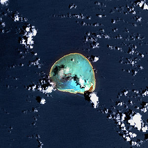
| Satellite image of the Kure Atoll | ||
| Waters | Pacific Ocean | |
| archipelago | Northwest Hawaii Islands | |
| Geographical location | 28 ° 25 ′ N , 178 ° 20 ′ W | |
|
|
||
| Number of islands | 2 | |
| Main island | Green Island | |
| length | 9.3 km | |
| width | 7.7 km | |
| Land area | 86 ha | |
| total area | 58 km² | |
| Residents | uninhabited | |
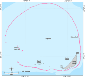
| Map of the Kure Atoll | ||
The Kure Island or the Kure Atoll ( Hawaiian : Mokupāpapa , also referred to as Ocean Island ) is located in the northern Pacific and belongs politically to the US state of Hawaii and geographically to the Northwest Hawaiian Islands . It is the westernmost island in this archipelago.
geography
Kure is almost 2,000 km from Honolulu , 80 km from neighboring Atoll Midway and 150 km from the date line . Kure is the northernmost of all coral atolls in the world. It is an atoll with a diameter of about 9 and a circumference of about 25 km and contains several small islands. The largest of these islands, Green Island , has an area of only 0.78 km², the total land area of the archipelago is 0.86 km². The fringing reef of the atoll is only open at one point and thus allows smaller ships to enter the lagoon . Kure has no permanent residents but is visited regularly by US Fish & Wildlife Service personnel .
The total area of the atoll is 58 km². The lagoon is up to 15 meters deep.
history
The atoll was probably discovered in 1820 by the Russian captain Kure , but this has not been proven for certain. It may not have been discovered until 1823 by Captain Benjamin Morrell . What is certain is, however, that in the aftermath repeatedly ships on the reef wrecked , among others, on 9 July 1837, the British ship Gledstanes or on 29 October 1870, the USS Saginaw . Due to the remote location of the island, it sometimes took many months before the castaways could be rescued.
Until 1992 there was a LORAN station of the United States Coast Guard on Kure , and there is also a small, fortified airfield .
Animal world (fauna)

The atoll is an important breeding area for sea birds . The brown booby ( Sula leucogaster ), the laysanalbatros ( Phoebastria immutabilis ) and the banded frigate bird ( Fregata minor ) are found here. Kure is also home to a significant population of the Hawaiian monk seal , with an estimated current population of around 100 to 125.
The entire atoll is a bird sanctuary and part of the Papahānaumokuākea Marine National Monument and may not be entered without the approval of the US Fish & Wildlife Service, and usually for research purposes only.
literature
- Edwin H. Bryan, Jr .: American Polynesia and the Hawaiian Chain; Honolulu. Hawaii 1942 (Rev. ed.)
Web links
- Information about Kure (English)
- About an expedition to the wreck of the USS Saginaw in 2006 (English)
Individual evidence
- ↑ United States Census Bureau, Kure Atoll including Green Island: Blocks 1023 and 1024, Census Tract 114.98, Honolulu County, Hawaii (English)
- ↑ Atoll Area, Depth and Rainfall ( page no longer available , search in web archives ) Info: The link was automatically marked as defective. Please check the link according to the instructions and then remove this notice.
- ↑ Jane's Oceania Page - Kure Island (English)
- ↑ Bishop Museum - NWHI Background History (English)
- ↑ NWHI Multi-Agency Education Project: about Kure Atoll (English)


