Northwest Hawaii Islands
| Northwest Hawaii Islands | |
|---|---|
| Map of the entire Hawaiian archipelago | |
| Waters | Pacific |
| archipelago | Hawaii |
| Geographical location | 26 ° 0 ′ N , 170 ° 30 ′ W |
| Number of islands | 10 islands / atolls |
| Main island | Midway Islands |
| Total land area | 14.3 km² |
| Residents | 40 (scientist) |
The Northwestern Hawaiian Islands or Windward (abbreviated NWHI , English Northwestern Hawai'ian Islands or Leeward , hawaiian Papahānaumokuākea ) are a chain of small islands , atolls and coral reefs in the central Pacific Ocean .
They are located northwest of the main islands ( Southeastern Hawaiʻian Islands or Windward Islands ) belonging to Kauaʻi and Niʻihau and, with the exception of the Midway Islands , which are a so-called non-incorporated territory of the USA , belong to the US state of Hawaii . Administratively, they are assigned to Honolulu County .
geography
The Northwest Hawaiian Islands extend in the Pacific Ocean at about 25 ° north latitude for a length of approximately 2000 kilometers from about 161 ° west longitude to the date line at 180 ° longitude.
The total land area of all islands is only about 14.3 km², of which almost half (6.23 km²) is on the Midway Islands.
The island chain includes in geographical order from southeast to northwest:
| map | Aerial photo |
Surname | Hawaiian | Area in ha |
Number of islands |
most densely 's population |
|---|---|---|---|---|---|---|

|
|
Nihoa | Nihoa (Moku Manu) | 70.0 | 1 | - |

|
|
Necker Island | Mokumanamana | 18.3 | 1 | - |

|

|
French frigate shoals | Kānemilohaʻi | 24.9 | 13 | - |

|

|
Gardner Pinnacles | Pūhāhonu | 2.4 | 2 | - |

|

|
Maro Reef | Nalukakala | 0.4 | - | - |

|
|
Laysan | Kauo | 411.4 | 1 | - |

|

|
Lisianski | Papaʻāpoho | 155.6 | 1 | - |

|

|
Pearl and Hermes Atoll | Holoikauaua | 36.0 | 6th | - |

|

|
Midway Atoll | Pihemanu | 623.0 | 3 | 40 1) |

|

|
Kure atoll | Mokupāpapa | 86.2 | 2 | - |
1) scientist
geology

The island chain is of volcanic origin and part of the Hawaii-Emperor chain that extends from Kamchatka to the island of Hawaii ( Big Island ) . It emerged from the same volcanic hotspot that formed the main Hawaiian islands and is currently responsible for the growth of the island of Hawaii at the southeast end of the archipelago.
While the Big Island is still growing, all the islands in the northwest are already shrinking again. Thus, the height of the Northwestern Hawaiian Islands usually decreases from southeast to northwest, northwest of the Kure Atoll then only so-called seamounts exist .
The age of the islands ranges from 7.2 million years (Nihoa) to 29.8 million years (Kure Atoll). Many of the older islands would no longer reach the surface of the sea or would be much smaller if corals had not started to build reefs on the old volcanoes. The reefs grow fast enough to compensate for the subsidence of the volcanic structures. With the old volcanoes further north this process could not take place, because north of 30 ° N the water is too cold for reef-forming corals (Kure is at 28.5 ° N).
population
Nihoa and Necker bear evidence of early Hawaiian settlement, but were uninhabited at the time of discovery by Europeans. The islands do not have a permanent population today, but the Midway Islands have around 40 residents, mostly scientific staff.
natural reserve
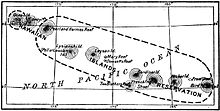
Because of the dramatic decline in bird populations all northwestern Hawaiian Islands were except Midway's US President already on February 3, 1909 Theodore Roosevelt bird sanctuary Hawaiian Islands Bird Reservation explained. The Midway Islands became part of the Pacific Island Wildlife Refuge Complex on October 31, 1996, after the withdrawal of the military .
After the island chain and its surrounding waters were declared a National Marine Sanctuary in 2002, now including Midways, George W. Bush proclaimed it to be Papahānaumokuākea Marine National Monument on June 15, 2006 . The National Monument initially covered more than 362,000 km². In 2016, Barack Obama enlarged the protected area to 1.5 million km². The islands may only be entered for scientific purposes with the special permission of the US Fish & Wildlife Service .
See also
Web links
- Northwestern Hawaiian Islands - trivia, photos (English)
- NWHI Network - Many current information (English)
- Private page with pictures of the NWHI (English)
- Side of the State of Hawaii (English)
literature
- David Liittschwager and Susan Middleton: The Other Hawaii. National Geographic Germany, G + J Verlag, Oct. 2005, pp. 136–56.
Individual evidence
- ↑ a b CIA World Factbook - Midway Atoll (English)
- ↑ John Rooney, Pal Wessel, Ronald Hoeke, Jonathan Weiss, Jason Baker, Frank Parrish, Charles Fletcher, Joseph Chojnacki, Michael Garcia, Russell Brainard, Peter Vroom: Geology and geomorphology of coral reefs in the northwestern Hawaiian Islands. In: BM Riegl, RE Dodge (Ed.): Coral Reefs of the World. Vol 1: Coral Reefs of the USA. Springer 2008, pp. 519–571, doi : 10.1007 / 978-1-4020-6847-8_13 (alternative full text in manuscript form: School of Ocean and Earth Science and Technology )

