
Länta Hut
| Länta Hut SAC refuge |
||
|---|---|---|
 Länta Hut |
||
| location | in the Valsertal ; Canton of Graubünden , Switzerland | |
| Mountain range | Gotthard massif | |
| Geographical location: | 722 954 / 155 742 | |
| Altitude | 2090 m above sea level M. | |
|
||
| owner | Section Bodan | |
| Built | 1913, 1968 new building, 2003/05 renovation | |
| Construction type | Refuge | |
| Usual opening times | Late June to mid October, mid March to late April |
|
| accommodation | 33 beds | |
| Winter room | the hut is always open | |
| Web link | www.laentahuette.ch | |
| Hut directory | SAC | |

The Länta hut is a mountain hut belonging to the Swiss Alpine Club (SAC), Bodan section, in the canton of Graubünden in Switzerland. It is located in Länta, the uppermost section of the Valsertal valley, southeast of the Zervreilahorn .
In addition to the valley, the Läntahorn mountain , the pass (Läntalücke) and a glacier ( Läntagletscher ) bear this name. With its many climbing routes and climbing gardens, the Länta is also a household name in the Swiss sport climbing scene.
At the moment (2019) the hut is closed because it was badly damaged by falling rocks. The damage has now been repaired, and it will reopen for the ski touring season in March 2020.
location
The Länta is the uppermost branch of the Graubünden Valsertal, which reaches deep into the Adula main ridge. The Länta Hut SAC, 2090 m above sea level. M. , is located in a slightly elevated position above the Valser Rhine near the Läntagletscher rising to the Rheinwaldhorn .
history
The hut stands on the site of the former Schafalp of the same name, which has been tended by shepherds from Ticino for centuries. In 1913, the Bodan section of the Swiss Alpine Club built a refuge, which was rebuilt in 1968 after avalanche damage and comprehensively renovated in 2005. On this occasion, it was deliberately decided not to expand the hut.
Approaches

The hut can be reached on foot from Zervreila in 2.5 to 3 hours on a good alpine path. Zervreila as a starting point can be reached by car all year round, provided it is cleared, by post bus from Ilanz and Vals in summer and by shuttle bus in winter when the Zervreila restaurant is open (provided the road is passable with it) . The Länta hut is always open and is managed from the end of March to the beginning of May (ski tours) and from the end of June to mid-October (hiking, mountaineering, climbing).
Tours / summit ascents
The hut serves as a starting point for skiing and high-altitude tours to the surrounding peaks (e.g. Rheinwaldhorn , Güferhorn , Grauhorn ) for pass hikes into Ticino (Passo Soreda) and to Vals (Furggelti) as well as for climbing tours (Zervreilahorn). Neighboring huts are the Zapporthütte , the Motterasciohütte , the Adulahütte SAC , the Adulahütte UTOE and the Terrihütte .
The Länta as a valley and settlement area (Lampertschalp) is rich in traces of an ancient pastoral culture. There were connections to the neighboring Valle di Blenio via the Soreda and Fornei passes, and via the Fuorcla Darlun to the Val Lumnezia . The Läntalücke, on the other hand, has more alpine significance due to the glaciated north side. The valley as a classic glacier trough and archaic shepherd's world was extremely fascinating for travelers to the Alps and found its way into Alpine literature early on.
Quote
"The Lentathal is a gem of the glacier world and is one of the most interesting valleys in Switzerland."
panorama

gallery

Länta hut from the path to Furggelti

The Länta Hut from the Zervreilahorn

Läntahütte

Läntagletscher with Rheinwaldhorn (view from the hut)
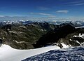
Läntatal and Läntagletscher from the Rheinwaldhorn


.jpg)

literature
- Rolf Goetz: Surselva , Rother Wanderführer, Bergverlag Rother , 1st edition 2003, pp. 116–117
Web links
- Bruno Lüthi: SAC hut dares the future , in: Die Alpen 9/2003 ( Memento from November 4, 2003 in the Internet Archive ) (PDF file; 148 kB)
- Homepage of the SAC section Bodan
- Homepage of the Länta Hut SAC
Individual evidence
- ↑ Postbus & Shuttle. December 13, 2019, accessed December 27, 2019 .