
Lüderitzland

Lüderitzland (also Lüderitz-Land , rarely Lüderitz-Territory ) was the name of a coastal strip in southwestern Africa. It was named after the Bremen merchants Adolf Lüderitz , who had the land acquired for his company under questionable circumstances in 1883, and his younger brother August Lüderitz , who bought territories there and conducted negotiations for the Reich. The country, placed under German protection in 1884, became the nucleus of the colony of German South West Africa , today's Namibia .
geography

Lüderitzland extended in the north to the 26th degree south latitude and in the south to the Oranje River . From the South Atlantic it stretched 20 German miles - about 150 kilometers - inland from any point on the coast. The penguin islands near the coast were not part of the Lüderitzland. The southern foothills of the Namib Desert protrude into this area . In addition, today's restricted diamond area was created here . A settlement of national importance is the place Lüderitz at the same Lüderitz . Today the Lüderitz constituency includes large parts of the former Lüderitzland.
history
Adolf Lüderitz was fascinated by the idea of founding a private colony under German protection. In the south-west of Africa, he learned, there was "ownerless" land with abundant natural resources - African natives were not viewed as "masters". On November 23, 1882 Lüderitz wrote to the Foreign Office in Berlin: “The country I am considering lies between the large and small fish river, that is between the 26th and 29th degree south latitude.” Lüderitz also sent the same Year an expedition to South West Africa led by his agent Heinrich Vogelsang .
The "mile fraud"


When Lüderitzland was founded on August 25, 1883, Lüderitz and Vogelsang were pleased that the resident Nama -Captein Joseph David Fredericks von Bethanien only needed the English mile (around 1.6 kilometers ), but not the German geographic mile (around 7 , 4 kilometers) was familiar. Lüderitz traveled to his new acquisitions made by Vogelsang in September 1883. The captain of the SMS Nautilus , Ascheborn, who visited him there in January 1884, found that Lüderitz's property in German miles was a good four times larger than in English measurements. Unaware of this difference, Fredericks had given much more territory than he assumed when he signed the contract. In a letter Lüderitz wrote to his agent Vogelsang: "For the time being, let Joseph Fredericks believe that it is 20 English miles." This misleading went down in history as the so-called "fraudulent miles" . In return, Frederiks von Vogelsang received £ 500 and 60 English rifles.
On December 31, 1883, Fredericks made a written statement setting out the historical background to his ancestral ownership. The Fredericks family is therefore the legal and sole owner of the area between the rivers Tsondab , Useb , Oranje, Gawa-Gam , Fish River and the sea. This protest note has been preserved in the files of the former Reich Colonial Office. In the contemporary German press, on the other hand, the "legality and strictest honesty" that prevailed on the part of Germany when this colony was founded was praised.
Starting point of German South West Africa
_detail.png)
Regardless of the dubious contractual basis, the German government granted Lüderitz's request on April 24, 1884 to protect his acquisition from British claims. German and British warships now frequently sought out the Bay of Angra Pequena - later Lüderitz Bay - to demonstrate their strength to each other. The German partisanship in favor of Lüderitz 'was expressed in a telegram that Reich Chancellor Bismarck sent to the German embassy in London: “According to the report of the commander SM Kbt' Natilus' and other news from Cape Town , the authorities there doubt that the land acquisitions and ] Mr. Lüderitz's business north of the Orange River are entitled to the protection of the Reich. I have therefore instructed the imperial consul in Cape Town to officially leave no doubt that this is the case. ”On August 7, 1884, on the instructions of August Lüderitz, the German flag was hoisted on the German corvettes lying in Lüderitz Bay and the Lüderitzland officially placed under the protection of the German Reich . On October 24, 1884, the newly appointed Reich Commissioner for German West Africa , Gustav Nachtigal , arrived in Bethanien and, in the presence of Frederick, sealed the German occupation with a "protection and friendship treaty". A German flag was hoisted in front of Fredericks' house . In April 1885, financial difficulties forced Adolf Lüderitz to sell his acquisitions for 500,000 marks to the newly founded German Colonial Society for South West Africa .
Lüderitzland continued to exist as a geographical name in later years and is recorded on numerous maps from the German colonial era .
gallery
- The founders of the Lüderitzland
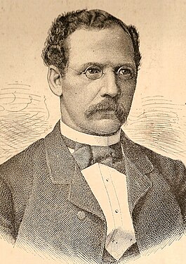
Adolf Lüderitz
(1834–1886)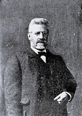
August Lüderitz
(1838–1922)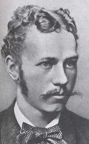
Heinrich Vogelsang
(1862–1914)


See also
literature
- Cameroon and Lüderitz-Land . In: The Gazebo . Issue 40, 1884, pp. 665, 667-668 ( full text [ Wikisource ]).
- Lüderitzland. In: Deutsches Kolonial-Lexikon , Volume II, Leipzig 1920, p. 466.
Individual evidence
- ↑ Guido Knopp : The world empire of the Germans - Of colonial dreams, wars and adventures . Revised paperback edition. Piper Verlag, Munich 2011, ISBN 978-3-492-26489-1 , p. 17.
- ^ Rochus Schmidt: Germany's colonies . Volume 2. Verlag des Verein der Buchfreunde Schall & Grund, Berlin 1898, p. 262 (reprint by Weltbild Verlag, Augsburg 1998, ISBN 3-8289-0301-0 )
- ↑ Lüderitz . In: Meyers Großes Konversations-Lexikon . 6th edition. Volume 12, Bibliographisches Institut, Leipzig / Vienna 1908, p. 771 .
- ^ German South West Africa. In: Encyclopædia Britannica . Retrieved September 2, 2019 .
- ^ Jürgen Petschull: Der Wahn vom Weltreich , Gruner + Jahr, Hamburg 1986, p. 54, ISBN 3-88199-315-0 .
- ↑ Gisela Graichen, Horst Founder : German Colonies - Dream and Trauma . Ullstein, Berlin 2005, p. 72ff., ISBN 3-550-07637-1 .
- ^ Jürgen Petschull: Der Wahn vom Weltreich , Gruner + Jahr, Hamburg 1986, p. 59, ISBN 3-88199-315-0 .
- ^ Wilfried Westphal: History of the German colonies . Gondrom, Bindlach 1991, ISBN 3-8112-0905-1 , p. 21.
- ^ Wilfried Westphal: History of the German colonies . Gondrom, Bindlach 1991, ISBN 3-8112-0905-1 , p. 20 ff.
- ↑ About "Germany's First Colony" ... In: Latest Mittheilungen , Volume II, No. 89. Berlin, August 29, 1884.
- ↑ Jürgen Petschull : The madness of the world empire . Gruner + Jahr, Hamburg 1986, p. 59, ISBN 3-88199-315-0 .
- ^ Rochus Schmidt : Germany's colonies . Volume 2. Verlag des Verein der Buchfreunde Schall & Grund, Berlin 1898, p. 262 f. (Reprint by Weltbild Verlag, Augsburg 1998, ISBN 3-8289-0301-0 )
Coordinates: 27 ° 0 ′ S , 16 ° 0 ′ E