
Sangerhausen district
| coat of arms | map |
|---|---|

|

|
| Basic data | |
| State : | Saxony-Anhalt |
| Administrative headquarters : | Sangerhausen |
| Area : | 689.77 km² |
| Residents : | 62,446 (December 31, 2006) |
| Population density : | 91 inhabitants per km² |
| Circle key : | 15 2 66 |
| License plate : | SGH |
| Circle structure: | 40 parishes |
| politics | |
| Last District Administrator : | Volker Pietsch ( CDU ) |
| map | |
  |
|
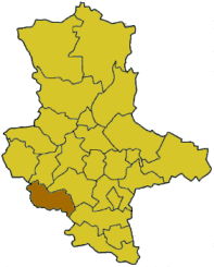
The district of Sangerhausen was a district in the south of the state of Saxony-Anhalt. On July 1, 2007 it was merged with the district of Mansfelder Land as part of the district reform in Saxony-Anhalt to form the new district of Mansfeld-Südharz . Neighboring districts were the districts of Quedlinburg and Mansfelder Land in the north, the district of Merseburg-Querfurt in the east, and the Thuringian districts of Kyffhäuser and Nordhausen in the south and west .
politics
District council
The district council was composed as follows:
| CDU | SPD | The left | FDP | Free Group | total | |
| 2004 | 16 | 7th | 10 | 7th | 2 | 42 |
(As of: Election on June 13, 2004)
cities and communes
(Resident on December 31, 2006)
- Sangerhausen , City (30,123)
Administrative communities with their member communities
* Seat of the administrative association
|
|
|
Territorial changes
Since 1995 there have been many changes to the area in the Sangerhausen district.
Of the original 8 administrative communities, there were still 3 administrative communities when the district was dissolved. At the same time, the number of parishes decreased from 52 to 40.
Changes in administrative communities
- Change of the community Edersleben from the administrative community Sangerhausen to the administrative community Helme (April 29, 2000)
- New formation of the administrative community Goldene Aue from the administrative communities Helme and "Kyffhäuser" Berga-Kelbra-Tilleda (January 1, 2004)
- New formation of the administrative community Roßla-Südharz from the administrative communities Roßla and Stolberg / Harz as well as from the communities Breitenbach , Großleinungen and Wolfsberg from the administrative community Südharz (January 1, 2005; name since May 13, 2005)
- New formation of the administrative community Allstedt-Kaltenborn from the administrative communities Allstedt and Kaltenborn (January 1, 2005)
- Dissolution of the administrative community Südharz - incorporation of the communities Breitenbach, Großleinungen and Wolfsberg into the administrative community Roßla-Südharz ; Integration of the remaining municipalities into the VG Sangerhausen (January 1, 2005)
- Change of the municipality of Pölsfeld from the VG Sangerhausen to the VG Allstedt-Kaltenborn (July 3, 2005)
- Dissolution of the VG Sangerhausen - incorporation of the member communities into the city of Sangerhausen (October 1, 2005)
Changes at the community level
- Dissolution of the communities of Breitenbach, Großleinungen and Wolfsberg - incorporation into Sangerhausen (October 1, 2005)
- Dissolution of the municipality of Riestedt - incorporation into Sangerhausen (December 1, 2005)
License Plate
At the beginning of 1991 the district received the distinguishing mark SGH . It was issued in the district of Mansfeld-Südharz until September 30, 2007. It has been available there again since November 27, 2012.

Cities : Dessau | Halle (Saale) | Magdeburg
Districts : Altmarkkreis Salzwedel | Anhalt-Zerbst district | Aschersleben-Staßfurt district | District of Bernburg | District of Bitterfeld | Bördekreis | Burgenland District | District of Halberstadt | District of Jerichower Land | District of Köthen | District of Mansfelder Land | District of Merseburg-Querfurt | Circle of ears | District of Quedlinburg | Hall circle | District of Sangerhausen | District of Schönebeck | District of Stendal | Weissenfels District | District of Wernigerode | Wittenberg district