
Lauberhorn run
| Lauberhorn | |
|---|---|
| Place: |
Wengen , Switzerland |
| Mountain: | Lauberhorn |
| Departure | |
| Begin: | 2,315 meters |
| Target: | 1,287 meters |
| Height difference: | 1,028 meters |
| Route length: | 4,480 meters |
| maximum slope: | 41 ° |
| average slope: | 14.2 ° |
The Lauberhorn run near Wengen in Switzerland is the longest run in alpine ski racing . It is one of the classics of the Alpine Ski World Cup, introduced in 1967, and has been the venue for the Lauberhorn race since February 1, 1930 .


It leads from the south shoulder of the Lauberhorn down to the hamlet of Schiltwald near Innerwengen, south of Wengen. The winners are currently tackling the almost 4,500-meter-long route in around 2:30 minutes.
The Lauberhorn run is also known for its backdrop of the Eiger , Mönch and Jungfrau .
history
The Lauberhorn races were founded in 1930 by the local ski racer Ernst Gertsch . They have been part of the FIS Alpine Ski World Cup since it was founded in 1967 . If Gertsch started in 1930 with a total budget of 500 Swiss francs , the total turnover of the Lauberhorn races is now eight million. The departure is visited by up to 38,000 people and over 400 journalists on site every year.
- see also Lauberhorn race
Routing
begin
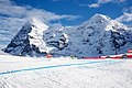
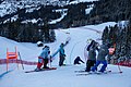
( 2315 m above sea level | 0.00.0 minutes by car) The start of the descent is at 2315 m above sea level. M. on the Lauberhorn shoulder , which can be reached from the Kleine Scheidegg using the chairlift. Unlike most World Cup start houses, the start house is a permanent wooden house. There is a clear view of the mountain scenery of the Eiger, Mönch and Jungfrau.

The race originally started with founder and racing driver Ernst Gertsch, around 1935

Lauberhorn chairlift from Kleine Scheidegg to the Lauberhorn shoulder, 2019

Interior of the start house, 2019

View from the start house to the Eiger, Mönch and Jungfrau, 2019

Starting gate, 2019

Race start of a Swiss athlete, around 2000

Race start by Beat Feuz , 2019


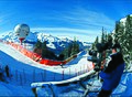
Start slope and upper curve
( 2315 m above sea level | 0.00.1 minutes by car) The upper section of the route is rather flat and consists of sliding blocks and long curves. The supposedly simple starting slope with a slight incline and hardly turning route is "deceptive" (Bernhard Russi), because it requires excellent acceleration and gliding skills. It turns into a long right-hand bend that leads to the Russisprung via a narrow passage between rocks and safety nets.
Russian jump
( 2180 m above sea level | 0.22.7 minutes by car) The jump was built by ex-ski racer and piste builder Bernhard Russi in 1988 and is named after him. Russi had the jump built for test shots the previous spring. At the instigation of race director Fredy Fuchs, the jump was integrated into the race track. The jump leads into flat terrain and ideally goes around 40 to 50 meters. The Russisprung leads past a reservoir that was created to feed the snowmaking systems.
Traverse shot
( 2120 m above sea level | 0.29.3 minutes by car) The Russisprung is followed by another glider section, the traverse shot interspersed with gentle curves and two cross- country waves . The speed increases here from 100 to over 130 km / h.
traverse
( 2010 m above sea level | 0.39.2 minutes by car) A sharp left curve forms the transition into the traverse, in which the terrain slopes to the right. Only here, after 40 driving seconds, is the first intermediate time measured. The start of the combination descent is in this region.
Panoramic curve
( 2000 m above sea level | 0.44.1 minutes by car) Due to the ever faster material, adjustments have always been necessary in the history of the Lauberhorn run. To reduce speed, the so-called panorama curve was created in order to reduce the speed of the drivers in front of the delicate passage on the Hundschopf. The long right-hand bend got its name from the view of the monumental peaks of the Eiger, Mönch and Jungfrau towering over the piste.

View over the starting slope , 2019

Slight curves on the starting slope , 2019

Elongated right curve after the starting slope , 2019

The Russi jump from below, 2019

An Austrian athlete masters the Russi jump , 2019

Traversenschuss , 2019
Panorama curve with Eiger and Mönch, 2019


Dog-head
( 1975 m above sea level | 0.53.7 minutes by car) After a tight S-curve to reduce speed, the most famous part of the descent follows, the spectacular jump over the Hundschopf . The edge lies on a narrow place between two rocks, where it goes 15 meters deep. The short fall area and the slope that immediately turns to the left make the place even more difficult. Bernhard Russi describes the place as follows: "In the smallest of spaces, everything that is required of a downhill skier comes into play. The curves in front of it are narrower than usual, between the rocks on the left and the safety net on the right are a maximum of 5 meters, the edge of the jump can only be guessed. the choice of line is shaped by the closure of the network and the driver's imagination. And then the bottomless! "

Jean-Luc Crétier jumps over the dog's head , around 1995

"And then the bottomless" - jump over the Hundschopf , 2019

The Hundschopf from above, 2019

The dog's head from the jump height, 2019

The Hundschopf from below, 2018

View from Girmschbiel to the Hundschopf , 2019


Minsch edge
( 1915 m above sea level | 0.59.4 minutes by car) Immediately after the left-hand bend is the Minsch ridge , where Josef Minsch fell heavily in 1965. It is a smaller jump, the difficulty of which, however, is that it is approached in a left movement and left in a right movement - the rider has to change the inner ski so to speak on the edge of the jump. Russi describes the position as an “ingenious combination of jump, curve and choice of line”.
Canadian Corner
( 1890 m above sea level | 1.03.5 minutes by car) The strongly turning curve at the left-sloping transition into the Alpweg is named after the Crazy Canucks , as it was fatal to Dave Irwin and Ken Read in 1976 . The goal is to remain crouched despite the strong rotation.
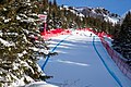
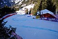
From here, the route briefly follows the valley of the Hasenbach, parallel to the Wengernalpbahn . The Girmschbiel hill on the opposite side of the small valley has become a fan stadium in the middle of the route thanks to its location right next to the Wengernalp train station . Over 10,000 visitors watch the race on the hill and in the bars and VIP zones that are temporarily set up there - only here do they have a direct view of the famous key points Hundschopf , Minsch-Kante and Canadian Corner .

A "target stadium" already halfway through the route: public area Wengernalp-Girmschbiel, 2018

Ski fans with Eiger, Mönch and Jungfrau, 2019

Approach to the Minschkante , 2019

Jump over the Minschkante , 2019

Canadian Corner , 2019

View from Girmschbiel to Canadian Corner , 2019

View from Wengernalp to Canadian Corner , 2019


Alpine path
( 1860 m above sea level | 1.08.3 minutes by car) The racers then drive on another, fast glider piece, the Alpweg . The section is only three meters wide connecting the upper and lower part of the descent in the middle of the steep slope in the Hasenbachtal and must therefore be secured with safety nets on the left.
Kernen-S / Brüggli-S
( 1825 m above sea level | 1.13.8 minutes by car) Russi calls the combination of curves following the Alpweg “the craziest chicane of the World Cup circus.” This very close combination of a right and a left curve leads over a short bridge. Due to the high entry speed of 100 km / h, the driver has to drift in order to reduce the speed and find the most technically sophisticated line possible without losing a lot of speed. Quite a few drivers are driven a little bit up the opposite slope on the exit. Some of the world's best downhill skiers such as Karl Molitor , Jean-Claude Killy , Toni Sailer or Karl Schranz retired at this technically difficult point. If the exit speed is too low here (at least 70 km / h are required), there is a risk of losing further time on the subsequent gliding passages.
Until 2007 this passage was still called Brüggli-S . It was renamed after the resignation of Bruno Kernen , who fell here badly in 1997 and was almost uninjured.

Bottleneck Alpweg , 2019

Kernen-S and water station from above, 2019
Entrance to Kernen-S via the "Brüggli", around 2000

The opposite slope before the exit from the Kernen-S , 2019
Exit from the Kernen-S with a jump towards the water station , 2019

The same position with regular piste operation, 2019


Steep slope in front of the water station
( 1775 m above sea level | 1.20.0 minutes by car) The racer reaches a steep slope via a small jump, but it is too short to pick up speed again if this has been lost in the Kernen-S.
Water station
( 1770 m above sea level | 1.23.6 minutes by car) Here the route leads through a short and narrow tunnel under the tracks of the Wengernalp Railway . The tunnel is only nine meters wide, although the passable area is much narrower due to the vaulted ceiling, the snow and the safety upholstery. After the tunnel, the route is unusually uphill for a few meters. This point is unique in the World Cup and is therefore one of the distinguishing features of the Lauberhorn route.

The water station was the start of a "no-case" race in 1927 three years before the Lauberhorn races were founded
The short steep slope at the water station , around 1990

Tunnel entrance at the water station , around 1990

Tunnel exit at the water station , 2019

View from the water station over the Langentrejen entrance , 2019

Exit water station with a view of Lauberhorn and Tschuggen, 2019


Langentrejen
( 1775 m above sea level | 1.24.8 minutes by car) This is followed by the extraordinarily long glider piece Langentrejen . Where the route was straight in the 1950s, today there are curves like in a Super-G . The route section has no key points and is also relatively unspectacular in terms of landscape, which is why it is partially omitted in television broadcasts. Nevertheless, this passage can be decisive for the race, as the driver here with the wrong material or insufficient gliding and aerodynamic abilities can lose the race. Mental conduct also plays a role, as the driver has time to reflect on his previous race on the long, rather flat passage.
Hannegguß
( 1590 m above sea level | 1.50.1 minutes by car) This impressive steep slope in the middle of the forest has the highest speeds of alpine ski racing at over 140 km / h. Here Johan Clarey achieved the highest speed ever measured in the Alpine Ski World Cup on January 19, 2013 in the descent of 161.9 km / h. The Hanegg Schuss is approached via a left curve. The upper part of the steep slope is somewhat flatter than the lower - the transition to the terrain can be "pushed" like a wave or jumped like an edge. The pace is so fast here that the skis only have contact with the ground every 10 meters. The compression at the foot of the steep slope must be handled with particular sensitivity.
The sliding piece Langentrejen , 2019

View over Langentrejen to Wengen, 2017

The Langentrejen slider with a view of the Jungfrau, 2019

View from Wengen to the Hannegg Schuss , 2019

The Hannegg Schuss with Silberhorn, 2019
View of the Hannegguß steep slope , 2019


Seilersboden
( 1470 m above sea level | 2.01.5 minutes by car) On the very flat Seilersboden , a long left-right combination leads to the Silberhornsprung. Russi writes: “A brief moment of calm. Here, on this little flat piece, breathing can return to normal. After the "crescendo" in the Hanegg Schuss, you have to switch to a fine pressure and tempo feeling in the flat left curve. "
Silberhornsprung
( 1450 m above sea level | 2.07.6 minutes by car) After this passage it goes over the Silberhornsprung, which was newly built in 2003 . The jump was arranged in such a way that in the camera view of the television broadcasts the Silberhorn can be seen in the background alongside the jumping racers . The difficulty here is the choice of line when approaching, as the jump is in the middle of a right-hand bend.
Divorce
( 1420 m above sea level | 2.09.1 minutes by car) The passage running through the forest is characterized by restless curves.
Austrian hole
( 1390 m above sea level | 2.13.9 minutes by car) The Österreicherloch belongs to the Wegscheide . It got its name in 1954 after the three Austrians Toni Sailer, Anderl Molterer and Walter Schuster fell at this point . The bumps that they threw off the slopes at that time have now been removed.

View from Hannegg to Seilersboden , 2019

Flat piece Seiler Floor , 2019

The Silberhorn jump in front of the Silberhorn in the year of its introduction in 2003

View from Silberhornsprung towards Wegscheide , 2017

Austrian Hole , 2019


Target-S
( 1385 m above sea level | 2.18.0 minutes by car) A sharp left curve followed by a bump leads to the last key point, the Ziel-S. At this point all other World Cup descents are long over. The technically difficult, strongly turning, often icy and restless right-left combination at the end of the long descent demands a lot of strength from the racers and often determines the outcome of the race.
In 1991 Gernot Reinstadler had a fatal accident here .

Technically demanding: Das Ziel-S , 2019
Entry to Ziel-S , 2012

Ziel-S with a fully occupied finish stadium, 2012


Target shot
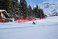
( 1325 m above sea level | 2.24.2 minutes by car) The Ziel-S leads over into the target shot , with a slope of 42 degrees after the Hundschopf, the steepest section of the route. The target jump was flattened before the 2009 race for safety reasons, and the driveway was widened. Before that, many drivers had crashed here, such as Peter Müller , Silvano Beltrametti , Adrien Duvillard and in 2007 Bode Miller - sliding across the finish line as the winner. The target shot still demands the last reserves of the drivers today.

Ernst Gertsch on target , around 1940

The target shot with the still poorly visited target area around 1965

The then extremely close target shot around 1985

The already wider target shot , 2006

The defused target shot , 2019


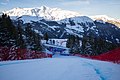
target
( 1287 m above sea level | 2.26.5 minutes by car) In contrast to the similarly spectacular Streif in Kitzbühel , the driver only sees the finish stadium with the temporary grandstand and the permanent media center at the height of the finish line. The destination is in Innerwengen, around one kilometer south of the village center.
The slalom takes place on the Jungfrau / Männlichen slope and ends in the same finish area as the descent.

View from the finish stadium onto the finish slope of the Lauberhorn downhill slope, 2016

View from the finish stadium onto the finish slope of the Jungfrau and Männlichen slalom slopes , 2017
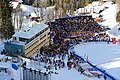
Finish stadium in Innerwengen with public stand and media house, 2012


Combination run
The super combination of the Lauberhorn race is the only one in the World Cup where the descent is still driven on a shortened route due to its enormous length: the start of the combined descent is at an altitude of 2,000 meters above the S-curve in front of the Hundschopf.
Record winner

The following racers were able to win the Lauberhorn run more than once:
- 6 wins
Karl Molitor (1939, 1940, 1942, 1943, 1945, 1947)
- 4 wins
Toni Sailer (1955, 1956, 1957, 1958); Karl Schranz (1959, 1963, 1966, 1969)
- 3 wins
Rudolf Graf (1941, 1944, 1949); Franz Klammer (1975, 1976, 1977); Beat Feuz (2012, 2018, 2020)
- 2 wins
Heinz von Allmen (1937, 1938); Bode Miller (2007, 2008); Othmar Schneider (1951, 1952); Fritz Steuri (1931, 1932); Stephan Eberharter (2002, 2003); Marc Girardelli (January 20 and 21, 1989)
literature
- Martin Born (ed.), Marcus Gyger (photo): Lauberhorn : The story of a myth . AS-Verlag, Zurich 2004, ISBN 3-909111-08-4 .
Web links
- International Lauberhorn Races Wengen
- Results of all World Cup runs from Wengen on fis-ski.com
- Live panorama cameras Lauberhorn
Individual evidence
- ↑ Sports news. (...) winter sports. (...) The ski competitions in Wengen. In: Reichspost , No. 33/1930 (XXXVII. Year), February 3, 1930, p. 5, center right. (Online at ANNO ).
- ^ Association for the International Lauberhorn Races [1]
- ↑ Reference for the approximate indication of the driving minutes when entering is Beat Feuz's victory drive from 2018, [2]
- ^ Martin Born: Lauberhorn. The story of a myth, Zurich 2004, p. 26.
- ^ Martin Born: Lauberhorn. The story of a myth, Zurich 2004, p. 42.
- ^ Martin Born: Lauberhorn. The story of a myth, Zurich 2004, p. 50.
- ^ Martin Born: Lauberhorn. The story of a myth, Zurich 2004, p. 64.
- ^ Martin Born: Lauberhorn. The story of a myth, Zurich 2004, p. 80.
- ↑ a b c d e Remo Geisser: Evolution of a dinosaur . In: Neue Zürcher Zeitung . No. 11 , January 14, 2012, p. 52 .
- ^ Martin Born: Lauberhorn. The story of a myth, Zurich 2004, p. 80.
- ↑ Innerhofer wins in Wengen. sport.orf.at, January 19, 2013, accessed on January 19, 2013 .
- ^ Martin Born: Lauberhorn. The story of a myth, Zurich 2004, p. 146.
- ↑ Lauberhorn target area becomes safer. In: Bernese Oberland . September 26, 2008.
- ^ Stefan Oswalt: An eternally young dinosaur. In: NZZonline. January 10, 2008, accessed January 18, 2012 .
- ↑ Richard Hegglin: Lauberhorn, the trickiest ski puzzle in the world. In: Basellandschaftliche Zeitung. January 13, 2012, accessed January 18, 2012 .
Coordinates: 46 ° 36 ' N , 7 ° 57' E ; CH1903: six hundred thirty-nine thousand and sixty / 160171