
Eiger
| Eiger | ||
|---|---|---|
.jpg) The north face of the Eiger |
||
| height | 3967 m above sea level M. | |
| location | Bernese Oberland , Switzerland | |
| Mountains | Bernese Alps | |
| Dominance | 2.21 km → Monk | |
| Notch height | 362 m ↓ Northern Eigerjoch | |
| Coordinates | 643 436 / 158638 | |
|
||
| Type | Rocky peaks with snow cover | |
| rock | limestone | |
| First ascent | August 11, 1858 by Christian Almer , Charles Barrington and Peter Bohren | |
| Normal way | over west flank ( ZS- ) | |
 Eiger area map |
||

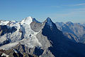
The Eiger is a mountain in the Bernese Alps with a height of 3967 m above sea level. M. It is in front of the main ridge of the Bernese Alps a little to the north and stands entirely on the territory of the Swiss canton of Bern . Together with Mönch and Jungfrau , whose peaks lie on the border with the canton of Valais , the Eiger dominates the landscape of the central Bernese Oberland . The northern flanks of these mountains, rising about 3000 meters above the valley, represent the face of one of the most famous summit groups in the Alps , ever known as a “triumvirate” .
The north face of the Eiger in particular fascinates both mountaineers and alpine laypeople. Dramatic attempts and successful ascent of this wall made the Eiger famous worldwide and repeatedly brought it into the public eye - not least because the entire wall can be seen from Grindelwald and the Kleine Scheidegg train station . The Jungfrau Railway with its tunnel through the Eigerfels has been a tourist magnet since it opened in 1912.
Origin of name
The first written mention of the Eiger comes from the year 1252 - this is the second earliest written mention of a Swiss mountain after the Bietschhorn (1233). On July 24, 1252, in a deed of sale between Ita von Wädiswyl and the Provost of Interlaken, a plot of land was demarcated with the words “ad montem qui nominatur Egere” ( German : up to the mountain, which is called the Eiger). Half a century later, the Eiger is mentioned for the first time in German in a mortgage lending letter: “under Eigere” .
There are three common explanations for the origin of the name. A first is the old high German name Agiger or Aiger , as the first settler below the Eiger is said to have been called. The mountain above its pastures was therefore called Aigers Geissberg or just Geissberg . From this the direct predecessors of the current name developed over time. The origin of the name could also come from the Latin word acer , from which aigu developed in French . Both words have the meaning sharp or pointed - based on the shape of the Eiger. The third explanation comes from the previously used spelling Heiger , which could have developed from the dialect expression "dr hej Ger" ( hej means high , Ger was a Germanic javelin). Again, the shape of the Eiger would be decisive for its name.
In connection with the Eiger, the name similarity with the ogre , a human-like monster, is often mentioned . Based on the triumvirate “Eiger-Mönch-Jungfrau”, there is the story that the monster Eiger wanted to put his lustful paws on the Jungfrau , but was prevented from doing so by the cheerful monk . Old caricatures and newer postcards relating to this story can be bought in Grindelwald.
Location and surroundings

The Eiger rises directly southwest of Grindelwald ( Interlaken district ). The well-known north face is actually a north-west face. In addition to this, there is also the north-east face in the famous "Eiger north view". It forms the basis for the sharp Mittellegigrat, which runs from the Lower Grindelwald Glacier to the summit. On the opposite side, the west ridge delimits the north wall. It is followed by the western flank in which the Eiger Glacier and the Klein Eiger are located. This is followed by the south-west ridge and, a bit to the east, the south ridge, which in turn limits the south-east wall, which extends to the Mittellegigrat. The Grindelwald-Fiescher Glacier is located southeast of the Eiger .
In the area around the Eiger there are some four-thousand-meter peaks of the Aarmassiv . In the east it is surrounded by the Schreckhorn ( 4078 m above sea level ) and Lauteraarhorn ( 4042 m above sea level ), in the south-east by the Great Fiescherhorn ( 4049 m above sea level ), and in the south-west is the Mönch ( 4107 m above sea level) . M. ) separated from the Eiger by the northern and southern Eigerjoch . Together with the Mönch and the Jungfrau ( 4158 m above sea level ), the Eiger forms the “triumvirate”, with the Eiger forming the northeastern end point and the Jungfrau being the southwestern end point. Opposite the steeply sloping north side of the mountain is the plateau and glacier world of the Bernese Alps in the south of the Eiger. Since the end of 2001, the Eiger has been part of the UNESCO World Natural Heritage Swiss Alps Jungfrau-Aletsch .
geology
The Eiger is part of the Helvetic system that forms the ceilings of the northern edge of the Alps in the greater area around Lake Thun . In a late phase of the Alpid mountain folding , the Helvetic limestone sediments were abraded from their crystalline base and shifted to the northwest in the form of a shear blanket. During the folding process in the Alpine formation broke the limestone beds and divide - and folding systems developed, which later precipitated calcite were closed. The most important components of the sediments are the Cretaceous Schrattenkalk and Malmkalk. Marl and clay slate were used as filling and lubricating material .
The clearly recognizable folds of the Helveticum with its banded, flat limestone layers can also be seen on the Eiger. The Eiger massif consists entirely of limestone from the Helvetic zone and closes off the flysch layers and the molasses of the Grindelwald basin steeply to the south. Because the Grindelwald valley basin is so richly structured, a wide variety of animals find a habitat here. South of the Eiger is the Aarmassiv with its Innertkirchner-Lauterbrunner-Kristallin. Some of this has pushed itself over the sediments of the Eiger. In the area of the monk, the sediments meet old crystalline. The typical rocks of the Helvetic system in the Eiger area emerged during the Jurassic , the middle period of the Mesozoic Era . The predominant lime is mixed with different rocks. There are marl- limestone and slate , clay- slate , ironoolite and calcareous sandstones .

The limestone layers of the Eiger lie on gneiss and are inclined by 60–70 ° to the north. The current shape of the Eiger was shaped by the Ice Ages . During the Ice Age , the glaciation reached to the foot of the north face. In the Würm Ice Age , the thickness of the ice was 200 meters less. The earth's surface was reshaped by the movement of the glaciers . Landscapes overlaid by ice were abraded , while uncovered areas were altered by weathering and other forms of erosion . With the retreat of the ice, the pressure conditions in the rock also changed, which had a shaping effect through relief movements. Characteristic for the Eiger and its shape was the all-round relocation of ice masses, which ensured that all walls were worn evenly and clearly. In addition, due to its exposure , the north face was more exposed to erosion processes such as frost weathering .
Rockslide

In 2006, a major landslide occurred on the Eiger , which aroused public interest. On the east side of the mountain, below the Mittellegigrate, rock movements had created a gap around 250 meters long, which reached a width of around 7 meters. Then the outer parts lowered several centimeters per day. One cause of this rock separation could have been the massive penetration of meltwater into the rock, as well as instability of the rock due to the retreat of the glacier below the rock drop as a result of global warming . On July 13, 2006 at 7:24 p.m., around 500,000 cubic meters of boulders fell on the Lower Grindelwald Glacier . A cloud of dust hovered over the community of Grindelwald for hours. In the afternoon of the same day, the so-called "Madonna of the Eiger" fell down into the valley. This was a slender rock tower about 30 meters high with a volume of around 600 cubic meters .
Since these events, the outcrop (total volume: approximately one million cubic meters of rock) from which the rock mass broke has been observed by the University of Lausanne . The observations showed that from July 2007 to August 2008 the nose moved 15 meters downhill on a sliding surface inclined to the east. In addition, the rock tilted two degrees to the northeast. The gap between the mountain and the boulder was 50 meters in August 2008. Rock fragments break off again and again and fall down to the valley. The mass is slowed down and stabilized by the glacier ice into which the rock nose slides. This prevents the nose from falling into the valley as a compact mass. So it is considered more likely that the rock will collapse on itself.
Martinsloch
In the east ridge, which slopes steeply to the Lower Grindelwald Glacier, there is a rock hole at an altitude of around 2500 meters, which, like the Martinsloch near Elm GL, is named after Saint Martin . Another common name is Heiterloch . A ray of sunshine falling through the hole shines on the church of Grindelwald twice a year: shortly after noon in the period from November 26th to 28th and January 13th to 15th. Between the end of November and the end of January, the event can be observed continuously at various locations in Grindelwald. According to legend, the hole was created when Saint Martin accidentally hit the Eiger too hard with a stick.
Climate, vegetation and wildlife

The zone of the Northern Alps, in which the Eiger is located, is dominated by an Atlantic climate . This leads to relatively high levels of precipitation with high humidity and a balanced temperature profile . Due to the prevailing western air currents, relatively humid and mild air comes into Switzerland. This has a cooling effect in summer and warming in winter and ensures high levels of precipitation. The climate of Grindelwald ( 1034 m above sea level ) is cool with moderate rainfall, the annual average temperature is 5.9 ° C and the annual rainfall is 1251 mm. At an altitude of 2400 m, on the other hand, precipitation of 3000 mm is reached. The reason for the high number of precipitation is the location against the western air currents. The Eiger is the first obstacle for the humid, Atlantic air masses. This results in slope precipitation and increased precipitation figures. For the lower Valais in the south, however, this barrier means, for example, greatly reduced precipitation. The temperature measurements on the Jungfraujoch ( 3580 m above sea level ) recorded a long-term average of −7.9 ° C. This results in a vegetation period in the valley of 200 days a year. It decreases with increasing altitude and only reaches 60 days at 2400 m. The soil basis is provided by rendzinen , which have formed on the limestone-rich rock around the Eiger. Characteristic of these soils are weakly basic pH-values , a Mull - horizon and low moisture. The vegetation levels on the Eiger can be subdivided as follows: submontane level up to 1100 m, high montane level up to 1600 m - although in forested areas it extends up to 1800 m, subalpine level and alpine level up to 2200 m.
vegetation

In the submontane zone around Grindelwald, greasy meadows are predominant , which have formed in formerly forested areas and regularly cultivated subsoil. Occurring plants include cranesbills , bluebells , snake knotweed and parsley . In the high-montane level there are also fat meadows. The forest vegetation is formed by sycamore and rowan berries up to 1400 m . At they close Arven - and spruce forest in which to the tree line at m ranges from 1800 to 2000. In between there are columbines and forest hyacinths as well as alpine roses . Below the Kleine Scheidegg in the subalpine zone, there are moors in which cotton grasses and sundew grow. The fat meadows occurring in the subalpine zone serve as pastures with goldpippau and brown clover in summer . Alpine lawns have formed above the tree line where the cows are not grazing. Their plants are well adapted to the inhospitable conditions of the mountains. These include arnica , edelweiss , gentian and the yellow pasque flower . Above 2200 m the vegetation in the rubble area decreases and there is no more vegetation where there is snow and ice all year round.
Wildlife

The fauna around Grindelwald was examined as part of the UNESCO research project Man and the Biosphere between 1979 and 1983. 116 different species of butterflies have been found in the lower valley basin , including white whiteflies (up to 1500 m), blue iridescent fire butterfly (up to 1600 m), sky-blue blues (up to 1900 m), checkerboard butterflies (up to 1,600 m) and the great mother-of-pearl butterfly (up to 1800 m). Eleven reptile and amphibian species were found in the high-montane level , including the alpine salamander , the blindworm and the common frog . A total of 101 bird species have been identified, for example black grouse and ptarmigan in the high-montane forest area . Deer were mainly found in the mixed forests. In addition, another 30 mammal species were discovered. Marmots , chamois and alpine ibex were widespread between 1600 m and beyond the alpine level. The investigations also revealed occurrences of 20 dragonfly and 28 grasshopper species .
Alpinism
Ascent history

The first ascent of the Eiger summit was achieved by the Grindelwald mountain guides Christian Almer and Peter Bohren together with their Irish guest Charles Barrington on August 11, 1858 from the Wengernalp over the western flank. Six years later, Lucy Walker became the first woman on the summit. On July 14, 1871, the southwest ridge was first climbed by William AB Coolidge with Christian Almer and other guides.
The first ascent of the south ridge was made on July 31, 1876 by the British George E. Foster with the mountain guides Hans Baumann and Ulrich Rubi. Two years later, in August, the quartet Paul Montadon, Max Müller, A. Rubin and Rudolf Wyss made the first guideless ascent. On August 6, 1884, Alois Pollinger from St. Niklaus and Ulrich Almer and their guest J. Stafford Anderson carried out the direct ascent from the south to the Eigerjoch. In 1890 the Eiger was climbed for the first time in winter by the Englishmen Mead and Woodroffe with the local guides Ulrich Kaufmann and Christian Jossi.
The Englishmen JW and FC Hartley with the Swiss guides Peter Rubi and Peter Kaufmann made the first unsuccessful attempt to inspect the Mittellegigrates (northeast ridge) on July 6, 1874. In 1880 the guides Josef Imboden and Josef Marie Biner from St. Niklaus tried with their guest Percy W. Thomas to climb the northeast ridge of the Eiger. In 1885 four Swiss guides led by Alexander Burgener and their Austrian guest Moritz von Kuffner came to the Great Tower on the Mittellegigrat . Two days later the guides Josef Marie Biner from St. Niklaus , Alexander Burgener and A. Kalbermatten carried out the first descent on Mittellegigrat with their guest M. Kuffner. On August 8, 1894, the Briton Claude A. MacDonald and the Grindelwalders Christian Jossi and Peter Bernet reached an altitude of 3500 m above sea level. M. and climbed from there the later Lauper route in descent. On May 18, 1921, the Japanese Maki Yūkō with Fritz Amatter, Fritz Steuri and Samuel Brawand succeeded in the first complete ascent of the Mittellegigrates.
On August 20, 1932, the Swiss Hans Lauper and Alfred Zürcher, together with the guides Josef Knubel from St. Niklaus and Alexander Graven from Zermatt, were the first to climb the Eiger north-east face in one day without artificial aids. Lauper wrote in the voice of the people : “The ascent of the last of the three north faces of the world-famous triad Jungfrau-Eiger-Mönch was a success. Alexander Graven and his teacher Josef Knubel had led and guided us all day long with ravishing enthusiasm (which seems to grow with the difficulty of the tour) and with knightly consideration. " Heinrich Harrer speaks of the last great first ascent in the classical style, which the pimple of the best Swiss mountain guides had opened. This first route through the north face of the Eiger is known today as the Lauper route : The route leads over 55 degree steep ice fields and has climbing difficulties from V.
The Germans Otto Eidenschink and Ernst Möller succeeded in climbing the south face of the Eiger for the first time in 1937. The ski pioneer Arnold Lunn and three Swiss made the first ski ascent over the Eiger Glacier, climbing to the summit on foot from the northern Eigerjoch. In 1938 the Germans Anderl Heckmair and Ludwig Vörg and the Austrians Fritz Kasparek and Heinrich Harrer made the first direct ascent of the Eiger north face.
So far 69 people have died on the Eiger, at least 52 of them in the north face (as of 2011). A small memorial was erected for them on the Fallbodensee between the Kleine Scheidegg and Eigergletscher stations . The number of deaths is significantly higher today - since 1997 alone, 26 people have died in accidents.
North face
→ Main article: Eiger north face

The approximately 1,650 meter high north face of the Eiger, which is difficult to climb, is one of the three large north faces in the Alps . After two rope teams had a fatal accident while trying to climb the wall, she was nicknamed the "Murder Wall".
The three Saxons Willy Beck, Kurt and Georg Löwinger made the first serious direct attempt at ascent, who climbed the north face in 1934 and reached a height of 2900 meters until they had to give up because of a fall. A year later, Karl Mehringer and Max Sedlmayr died in a snow storm. In 1936 the well-known and filmed drama occurred in which Eduard Rainer, Willy Angerer, Andreas Hinterstoisser and Toni Kurz perished. The four climbers from Germany and Austria had to retreat after Angerer was injured and fell into a sudden fall in the weather . The last person alive, Toni Kurz, could not abseil far enough at an overhanging point and died exhausted a few meters above the rescuers.
The Eiger North Face was climbed for the first time from July 21 to 24, 1938 by Anderl Heckmair and Ludwig Vörg as well as Heinrich Harrer and Fritz Kasparek . In 1950 the Austrians Leo Forstenlechner and Erich Waschak climbed the wall for the first time in one day, in 18 hours. The Swiss Michel Darbellay managed the first solo ascent of the wall on the Heckmair route in 1963. A year later, Daisy Voog from Munich became the first woman to climb the north face.
In 1999, the German extreme mountaineer couple Robert Jasper and Daniela Jasper opened the route Symphonie de liberté X- / 8a, the first route with this difficulty and at that time the most difficult route in one of the great alpine north faces in modern free climbing style.
In November 2015, Ueli Steck climbed the wall in a record time of 2 hours and 22 minutes. The Swiss Ueli Steck and Nicolas Hojac hold the record for rope teams with 3 hours and 46 minutes, also since November 2015.
In 2015 the route Odysee X- / 8a + was first climbed by the German Robert Jasper , the Swiss Roger Schäli and the Italian Simon Gietl . They have opened the most difficult route through the most repellent part of the Eiger north face, the Rote Flue, in a modern free-climbing style.

There are now 33 routes leading through the wall (as of August 2008). The most famous and classic route is the Heckmair route , the route of the first climber. The overall difficulty is given as extremely difficult ( AS ) and difficulty level V must be mastered when climbing . The tour usually lasts two to three days. Due to the many crossways , the wall height of 1,650 meters results in a climbing route of four kilometers.
The ascent attempts in the 1930s were exposed to great criticism, which was expressed above all in Switzerland and England. As a result, the government of the canton of Bern issued a ban on climbing the north face of the Eiger in 1936, but this was lifted again because it was not legally tenable. The criticism was in part related to the ruling National Socialist regime in Germany , whose propaganda was happy to pick up on the successes of the German and Austrian clusters. The accusation that they tried and climbed the north face "for the National Socialists" was denied by the first climbers. They were well aware that success could have a positive impact on their future lives.
Routes on the Eiger
View of the Mittellegigrat from the Wetterhorn

Eiger detailed map

View of the mushroom from the west ridge


The normal route over the western flank begins at the Eigergletscher station of the Jungfrau Railway. During the tour, which takes between nine and twelve hours for ascent and descent, climbing difficulties up to the second degree and a slope between 40 ° and 45 ° are usually overcome. Depending on the snow conditions and degree of icing, up to III. Difficulty level to be climbed. The route first leads north of a striking couloir over rocks and firn fields, then around a steep step south to the large shoulder of the west ridge, on which the last part of the ascent runs. The path is marked with poles that can also be used for safety.
Since the summer of 2000, a via ferrata has been leading to the Rotstock ( 2,669 m above sea level ), a pre-summit of the Eiger above the Eiger Glacier station. The approach is from the Eigergletscher station of the Jungfrau Railway via a piece of the Eiger Trail hiking trail and leads from there towards Rotstock. At point 2400, the protection with wire ropes begins. The path is made easier by iron ladders and the via ferrata can be classified as easy. The tour is approximately three hours long, including the ascent and descent.
From 1899 to 1903, a via ferrata led to the Rotstock. The starting point of the secured climb was the temporary Rotstock station ( 2520 m above sea level ). From that time there are steps and an iron ladder that have been carved into the stone. The rest had been removed during the shooting of Luis Trenker 's last film, His Best Friend (1962).
Three meters deducted from the west ridge extends a free-standing, twelve-meter high rock tower ( 3219 m above sea level. M. ) up over the western North Face, who as fungus or mushroom is called. The first person on the mushroom is said to have been Richard M. Barrington, brother of the Eiger first climber, in 1876. According to mountain guide Peter Bohren, Barrington had dared to jump onto the mushroom from the west ridge. However, this anecdote is not certain. Today a climbing route ( Magic Mushroom , difficulty: 7c +) leads from the Stollenloch to the Pilz. It is also popular with base jumpers , who jump from here with parachutes into the depths. The Swiss Ueli Gegenschatz and the Austrian Hannes Arch jumped for the first time in 2000 .
The following routes are other common ways to get to the top of the Eiger:
| route | difficulty | Duration ( h ) | starting point |
|---|---|---|---|
| Mittellegigrat (northeast ridge) | S (difficult), III | 4–5 (from the hut) | Mittellegihütte ( 3355 m above sea level ) |
| South ridge | ZS (quite difficult), III | 5-6 | Mönchsjochhütte ( 3657 m above sea level ) |
| Southwest ridge | ZS | 6-8 | Eiger glacier station ( 2320 m above sea level ) |
| Southeast wall | SS (very difficult) | 10-12 | Eismeer station ( 3159 m above sea level ) |
| West ridge | AS (Extremely Difficult), VI | 9-11 | Eiger glacier station |
| West flank (Normaroute) | ZS, to III, widely II | 9-12 | Eiger glacier station |
Development
A number of structural measures have taken place on and in the Eiger over the years. The planned development of the summit was not done, but all stations of the Jungfrau Railway are located in the Eiger area, with the exception of the Jungfraujoch terminus . In addition, three mountain huts were built in the Eiger catchment area.
Eigerbahn

In the course of planning the Jungfrau Railway , the executives of the Bernese Oberland Railway, Emil Strub and Hans Studer, came up with a combination of a cogwheel and cable car from the Kleine Scheidegg over the Eiger Glacier to the summit. A license application for this project was submitted and approved in early 1892 . It was thus in direct competition with the Jungfrau Railway project by the engineer Maurice Koechlin , which had also been approved but was not implemented. When the Zurich industrialist Adolf Guyer-Zeller presented another Jungfrau Railway project, the Eiger Railway project was in jeopardy, as both projects initially envisaged the same route via Kleine Scheidegg and Eiger Glacier. The two planners therefore wanted to sell their concession to the operators of the Wengernalp Railway so that construction could begin quickly. Their shareholders were convinced by Guyer-Zeller of the Jungfrau Railway project and its better return opportunities , so that the Wengernalp Railway did not accept the approval for the Eiger Railway. The two competitors received a so-called standstill payment of 15,000 francs from Guyer-Zeller , and Strub became the first director of the Jungfrau Railway Company. After the opening of the Eigerwand station in 1903, the Jungfrau Railway Company submitted a further license application for a branch line from the planned Eismeer station to the Eiger. A cable car was to be built from the Arctic Ocean over the Eigerjoch to the Eiger summit. However, the Swiss Federal Council only wanted to approve this plan if the Jungfrau Railway would not continue to be built in the direction of the Jungfrau, which the company refused. The citizens of Grindelwald made one last unsuccessful attempt to technically develop the Eiger themselves. They wanted to implement a cable car project from the lower Grindelwald glacier to the Arctic Ocean, but ultimately the project was not implemented.
Jungfrau Railway
→ Main article: Jungfrau Railway
.jpg)

The first almost six kilometers of the Jungfrau Railway and the first four stations are in the Eiger area. The route begins at the Kleine Scheidegg ( 2061 m above sea level ) and leads from there to the Eigergletscher train station ( 2320 m above sea level , km 2). This is followed by the four-kilometer-long Eiger Tunnel, half of which circled the mountain underground. In it are the Eigerwand ( 2865 m above sea level , km 4.3) and Eismeer ( 3159 m above sea level, km 5.7). Between Kleiner Scheidegg and the Eigerwand station was the temporary Rotstock station ( 2520 m above sea level ), which, however, became less important after the opening of the following stations and was no longer used regularly. The terminus is the Jungfraujoch ( 3454 m above sea level, km 9.3). The route leads past seven artificial openings in the Eigerfels. The first is the tunnel entrance on the Eiger Glacier, followed by one at the Rotstock station, an explosion hole in the north face (explosion accident involving 30 tons of explosives) and the tunnel hole, also in the north face, which has become famous in mountaineering history. This is still important for alpinism today - it serves as an entry into the wall as well as an emergency exit and is also used for rescue operations. Two viewing options have been created for the Eigerwand station: one just before and one at the station itself. The highest opening is at the Eismeer station.
A large part of the construction history of the Jungfrau Railway took place on and in the Eiger. After construction began in 1896, the base station for further construction work was created in 1897 on a site on the Eiger Glacier. In addition to a train station, restaurant and an administration building, workers' barracks, shed houses and material stores were built. Up to 200 workers lived here all year round in the 16 years up to the completion of the railway.
Mountain huts
At the Lower Challiband there is a cave in the rock of the Eiger. It was first described by Caspar Rohrdorf in 1828 and was the very first “accommodation” on the Eiger. Rohrdorf himself had stayed in her. According to the local historian Rudolf Rubi from Grindelwald, the initials "CA" carved into the cave suggest that Christian Almer was the first to climb the Eiger .
The Berglihütte ( 3299 m above sea level ) was the first hut to be built southeast of the Eiger in 1869 on the Berglifelsen in the Arctic Ocean, the eighth hut of the Swiss Alpine Club . First the building was built in the valley and then moved to its location. In 1883 and 1903 the buildings had to give way to better new constructions. Since the Mönchsjochhütte went into operation in 1979 , the difficult-to-reach mountain hut has lost its alpine importance.
The first climber of the Mittellegigrate Maki Yūkō donated 10,000 francs to offer the subsequent climbers safe accommodation on the ridge (Maki and his companions had to bivouack unprotected on the ridge). The Mittellegihütte was built in 1924 at an altitude of 3355 m above sea level. M. It only had to be renovated 62 years later, whereby the original condition was retained. Because there was usually a lack of space in the hut, a steel structure was created a few meters next to it, in which there is room for another twelve climbers. Today it serves as a bivouac when the hut is closed. This increased the number of sleeping places to almost 30. In 2001, the Grindelwald mountain guide association built a completely new hut with 36 overnight accommodations and a lounge with kitchen. The old Mittellegihütte was transported away as a whole by a helicopter and is now in the museum at the Eigergletscher station.
For the 100th anniversary of the Grindelwald Mountain Guide Association, the mountain guides built the Eiger-Ostegghütte ( 2317 m above sea level ) on the northeasternmost foothills of the Mittellegigrat .
Popular culture and advertising
The Eiger has also found its way into popular culture and advertising in a variety of ways . The name is mainly used for tourism purposes by the community of Grindelwald: The Eigertrail hiking trail offers tourists the opportunity to hike from the Eigergletscher station of the Jungfrau Railway under the north face to the Alpiglen station of the Wengernalp Railway. In addition, the Eigerness brand was created in order to be able to better market the special features of Grindelwald and its surroundings under it. The Eiger live week is conceived as a so-called mountain festival, where various opportunities are offered to get closer to the mountains, mountain sports and nature. During this week, from 2008 to 2010, the Eiger Award was presented, which the organizers wanted to establish as the «Mountaineering Oscar ». It was awarded to people who came into the public eye through their alpine achievements. The previous winners were Ueli Steck 2008, Simone Moro and Denis Urubko 2009 and Marko Prezelj 2010. The award was suspended in 2011 due to financial problems. In addition, many hostels are named after the famous mountain.
Numerous mountain sports article manufacturers have products with the name «Eiger» in their range. The name is also used as a name or suffix for many different more or less suitable things or products, such as a climbing hall or fishing boots.
literature
- Uli Auffermann: The large Eiger Lexicon - The Eiger north face from AZ. Schall Verlag, 2013, ISBN 978-3-900533-76-2 (online)
- Uli Auffermann : In the shadow of the north face - triumph and tragedy on the Matterhorn, Eiger and Grandes Jorasses. Bruckmann Verlag, Munich 2011, ISBN 978-3-7654-5626-8 .
- Daniel Anker (Ed.): Eiger - The vertical arena. 4th, revised. Edition. AS Verlag , Zurich 2008, ISBN 978-3-905111-51-4 .
- Rainer Rettner: Eiger - Triumphs and Tragedies 1932–1938. AS Verlag, Zurich 2008, ISBN 978-3-909111-49-7 .
- Heinrich Harrer : The white spider. The big book from the Eiger. 5th edition. Ullstein Verlag, Berlin 2006, ISBN 3-548-36229-X .
- Robert Jasper : North Face my life with the Eiger. Delius Klasing Verlag, 2015, ISBN 978-3-667-10295-9 .
Filmography
- Ridge to heaven . Otto Ritter, 1948: Documentary about an ascent of the Mittellegigrates
- On behalf of the dragon , (Original title: The Eiger Sanction ). Clint Eastwood , 1975: feature film
- The Alps (original title: The Alps ). Michael Gambon , 2007: IMAX film about the Swiss Alps with ascent of the north face
- North face . Philipp Stölzl , 2008: Feature film about the ascent attempt in 1936 with Benno Fürmann .
Web links
- Eiger on Peakbagger.com (English)
- Eiger on GeoFinder.ch
- Eiger chronicle by Marco Bomio
- Daniel Anker: Eiger. In: Historical Lexicon of Switzerland .
Individual evidence
- ↑ As of 2008 according to: Daniel Anker (Ed.): Eiger - The vertical arena. 4th, revised. Edition. AS Verlag, Zurich 2008, p. 71.
- ↑ a b c d Daniel Anker (Ed.): Eiger - The vertical arena. 4th, revised. Edition. AS Verlag, Zurich 2008, p. 71.
- ↑ John Harlin: The wall of all walls - The Eiger, my father and me. Piper, Munich 2007, ISBN 978-3-492-25264-5 , p. 12f.
- ^ Toni P. Labhart: Geology of Switzerland. 5th, revised. Edition. Ott Verlag, Thun 2001, p. 78ff.
- ^ Geological map of Grindelwald (www.cde.unibe.ch) Retrieved on January 20, 2009 ( Memento of April 8, 2009 in the Internet Archive )
- ^ Toni P. Labhart: Geology of Switzerland. 5th, revised. Edition. Ott Verlag, Thun 2001, pp. 70ff.
- ↑ Martin A. Koenig: Small Geology of Switzerland - Introduction to the construction and development of the Swiss Alps. 3. Edition. Ott, Thun 1978, p. 83.
- ↑ Johann G. Ebel: Instructions to travel to Switzerland in the most useful and enjoyable way (second section: G – O). 3. Edition. Zurich 1810, p. 178. from books.google.de (accessed December 30, 2008)
- ↑ www.wissen.de/eiszeit Retrieved on November 21, 2018
- ^ Eduard Imhof: Switzerland at the last ice age 1: 550 000. In: Atlas der Schweiz. Federal Office for Topography, 1978, archived from the original on October 27, 2014 ; accessed on March 31, 2009 .
- ↑ Legacies of the Great and Little Ice Age - A geographical image presentation. (PDF) (No longer available online.) In: Swissfaces. 2006, formerly in the original ; accessed on March 31, 2009 . ( Page no longer available , search in web archives )
- ↑ Joachim Hoelzgen: The wall on the Eiger wobbles. on: spiegel.de. 2006, Retrieved January 12, 2009.
- ↑ Joachim Hoelzgen: Interview on the Eiger rock fall with Hans Rudolf Keusen. on: spiegel.de. 2006, Retrieved March 3, 2009.
- ↑ Eiger rocks tumble onto glaciers. In: Spiegel online. July 14, 2006, accessed January 12, 2009.
- ↑ Sarah Nowotny: The Brocken slides on. In: The Bund. August 19, 2008, p. 27.
- ↑ Marco Bomio: Sun through Martinsloch. Retrieved November 27, 2015 .
- ↑ Heiterloch. In: Bülach observatory. Archived from the original on September 9, 2012 ; Retrieved March 10, 2013 .
- ↑ Martinsloch Grindelwald. (No longer available online.) Archived from the original on March 14, 2013 ; accessed on November 21, 2018 .
- ↑ The Swiss Climate - A Brief Overview ( Memento from April 8, 2009 in the Internet Archive ), accessed on November 21, 2018.
- ↑ The climate of the last 10,000 years (for Grindelwald); Retrieved March 31, 2009 ( Memento July 3, 2007 in the Internet Archive )
- ↑ Weather records in Switzerland (as of 2005) ( Memento from September 14, 2008 in the Internet Archive ) Retrieved on November 20, 2018.
- ↑ Overview of the vegetation in Switzerland. (PDF) (No longer available online.) P. 1 , formerly in the original ; accessed on March 31, 2009 . ( Page no longer available , search in web archives ) Info: The link was automatically marked as defective. Please check the link according to the instructions and then remove this notice.
- ↑ Levels of vegetation and animal distribution around Grindelwald; accessed on March 31, 2009 ( memento of April 8, 2009 in the Internet Archive )
- ↑ The flora around Grindelwald; Retrieved on March 31, 2009 ( Memento from November 27, 2005 in the Internet Archive )
- ↑ The animal world around Grindelwald; accessed on March 31, 2009 ( memento of April 8, 2009 in the Internet Archive )
- ↑ Christian Imboden: Mountains: Profession, Vocation, Fate. Rotten Verlag, Visp 2013, pp. 85 and 120.
- ↑ Christian Imboden: Mountains: Profession, Vocation, Fate. Rotten Verlag, Visp 2013, p. 117.
- ↑ Christian Imboden: Mountains: Profession, Vocation, Fate. Rotten Verlag, Visp 2013, p. 121.
- ↑ a b c Daniel Anker (Ed.): Eiger - The vertical arena. 4th, revised. Edition. AS Verlag, Zurich 2008, p. 281ff.
- ↑ Christian Imboden: Mountains: Profession, Vocation, Fate. Rotten Verlag, Visp, 2013, pp. 102 and 155
- ↑ Heinrich Harrer: The White Spider. Ullstein, Berlin 1958, pp. 19 and 60.
- ↑ Daniel Anker: The victims of the Eigerwand. In: Daniel Anker (Ed.): Eiger - The vertical arena. 4th, revised. Edition. AS Verlag, Zurich 2008, pp. 302f.
- ↑ Dead climber recovered from the Eiger. In: Neue Zürcher Zeitung (online). March 26, 2009, accessed July 20, 2015 .
- ↑ The North Face Dramas staged on an adventure trail. (No longer available online.) In: Jungfrau Railways. June 24, 2011, archived from the original on March 4, 2016 ; accessed on November 20, 2018 .
- ↑ Marco Bomio: Whether the mountain guide Christian Almer had a premonition. In: Berner Zeitung. July 14, 2015, accessed July 20, 2015 .
- ↑ Two climbers die again in Switzerland. In: Focus online. July 6, 2012, accessed July 20, 2015 .
- ↑ Yvonne Schmoker: Blitzschlag: How a mountaineer experienced the drama on the Eiger. In: Berner Zeitung. August 9, 2013, accessed July 20, 2015 .
- ↑ SDA: French alpinist dies on ski tour on the Eiger. In: look. March 20, 2015, accessed July 20, 2015 .
- ^ Daniel Anker (Ed.): Eiger - The vertical arena. 4th, revised. Edition. AS Verlag, Zurich 2008, p. 12.
- ^ Karl Hausmann, Bernd Rathmayr: Alpine tours of the Bernese Alps. Part 4: Jungfrau Region. SAC-Verlag, 2010, ISBN 978-3-85902-308-6 .
- ↑ Natalie Berry: ukclimbing.com Ueli Steck Reclaims Eiger Speed Record UK Climbing online on November 18, 2015. Accessed on November 18, 2015.
- ↑ Yves Brechbühler: New team record in the Eigerwand. In: Jungfrau newspaper online. November 12, 2015, accessed November 18, 2015.
- ↑ planetmountain.com
- ^ Daniel Anker (Ed.): Eiger - The vertical arena. 4th, revised. Edition. AS Verlag, Zurich 2008, p. 92.
- ↑ a b c d Info: Eiger (tour book on alpin.de) Accessed on January 12, 2009.
- ↑ Daniel Anker: Difficult crack - A wall divides the country. In: Daniel Anker (Ed.): Eiger - The vertical arena. 4th, revised. Edition. AS Verlag, Zurich 2008, p. 64ff.
- ↑ Rainer Amstädter: Spider - Hitler climbed. In: Daniel Anker (Ed.): Eiger - The vertical arena. 4th, revised. Edition. AS Verlag, Zurich 2008, p. 220ff.
- ↑ Rotstock via ferrata. In: Grindelwald.swiss. Retrieved November 20, 2018 .
- ↑ Daniel Anker: Broken pillar - search for traces of the Eiger Trail of yore. In: Daniel Anker (Ed.): Eiger - The vertical arena. 4th, revised. Edition. AS Verlag, Zurich 2008, p. 46ff.
- ^ Daniel Anker (Ed.): Eiger - The vertical arena. 4th, revised. Edition. AS Verlag, Zurich 2008, p. 270.
- ↑ Patrick Moser: First pillar - The Eiger, inexperienced. In: Daniel Anker (Ed.): Eiger - The vertical arena. 4th, revised. Edition. AS Verlag, Zurich 2008, p. 38ff.
- ↑ Patrick Moser: Stollenloch - The queen of the mountain railways and its dark side on the Eiger Glacier. In: Daniel Anker (Ed.): Eiger - The vertical arena. 4th, revised. Edition. AS Verlag, Zurich 2008, p. 50ff.
- ↑ Marco Bomio: Swallow's Nest - From the Eiger cave to the Eiger-Ostegghütte. In: Daniel Anker (Ed.): Eiger - The vertical arena. 4th, revised. Edition. AS Verlag, Zurich 2008, p. 82ff.
- ^ Association. (No longer available online.) In: Eigerness.ch. Archived from the original on December 8, 2015 ; accessed on November 20, 2018 .
- ↑ Jungfrauzeitung.de website. Accessed November 20, 2018.